Related Research Articles

Moortown is an affluent suburb of Leeds, West Yorkshire, England in the LS17 and LS8 postcode districts. It is a civil parish and sits in the Moortown ward of Leeds City Council in the north east of the city.

Horsforth is a town and civil parish in the City of Leeds, West Yorkshire, England, five miles north-west of Leeds city centre. Historically a village within the West Riding of Yorkshire, it had a population of 18,895 at the 2011 Census. It became part of the City of Leeds metropolitan borough in 1974. In 1999, a civil parish was created for the area, and the parish council voted to rename itself a town council. The area is within the Horsforth ward of Leeds City Council, which also includes the southern part of Rawdon.

Hunslet is an inner-city suburb in south Leeds, West Yorkshire, England. It is 1 mile (1.6 km) southeast of the city centre and has an industrial past.

Alwoodley is a suburb and civil parish of Leeds in West Yorkshire, England. It is 5 miles (8.0 km) north of central Leeds and is one of the most affluent areas of the county. Alwoodley lies in the LS17 postcode area which was reported to contain the most expensive housing area in Yorkshire and the Humber by The Times.

West Park is a suburb of north-west Leeds, West Yorkshire, England, north of Headingley. It is a mixed area of private suburban housing and suburban council estates. The name derives from its main park containing playing fields together with a conservation area of grassy meadow ending in woodland. The largest housing estate in West Park is Moor Grange.

Rawdon is a village and civil parish in the metropolitan borough of the City of Leeds, West Yorkshire, England. It sits on the River Aire and on the A65 south of Yeadon.
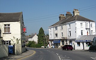
Shadwell is a village and civil parish in north-east Leeds, West Yorkshire, England. The village is 6 miles (9.7 km) to the north east of Leeds city centre.

The County Borough of Leeds, and its predecessor, the Municipal Borough of Leeds, was a local government district in the West Riding of Yorkshire, England, from 1835 to 1974. Its origin was the ancient borough of Leeds, which was reformed by the Municipal Corporations Act 1835. In 1889, when West Riding County Council was formed, Leeds became a county borough outside the administrative county of the West Riding; and in 1893 the borough gained city status. The borough was extended a number of times, expanding from 21,593 acres (8,738 ha) in 1911 to 40,612 acres (16,435 ha) in 1961; adding in stages the former area of Roundhay, Seacroft, Shadwell and Middleton parishes and gaining other parts of adjacent districts. In 1971 Leeds was the fifth largest county borough by population in England. The county borough was abolished in 1974 and replaced with the larger City of Leeds, a metropolitan district of West Yorkshire.
Lawnswood is a small suburb in the north west of the city of Leeds in West Yorkshire, England. As such it is north north east of the West Yorkshire Urban Area. The suburb falls within the Adel and Wharefdale Ward of the City of Leeds Council.

Burley is an inner city area of Leeds, West Yorkshire, England, 1 mile (1.6 km) north-west of Leeds city centre, between the A65 Kirkstall Road at the south and Headingley at the north, in the Kirkstall ward.

Tinshill is a district of Leeds, 4 miles (7 km) north of Leeds city centre, West Yorkshire, England. It was the Danes in the 9th century who named the hill "Tyndr's Hyll".

Leeds, also known as the City of Leeds, is a metropolitan borough with city status in West Yorkshire, England. The metropolitan borough includes the administrative centre of Leeds and the towns of Farsley, Garforth, Guiseley, Horsforth, Morley, Otley, Pudsey, Rothwell, Wetherby and Yeadon. It has a population of 809,036 (2021), making it technically the second largest city in England by population behind Birmingham, since London is not a single local government entity. Local governance sits with Leeds City Council and the city's 32 Parish Councils.

Chapel Allerton is an inner suburb of north-east Leeds, West Yorkshire, England, 2 miles (3.2 km) from the city centre.

Alwoodley is an electoral ward of Leeds City Council in the north of Leeds, West Yorkshire, covering the urban suburb areas of Alwoodley, the majority of Moor Allerton and Slaid Hill.
There are a number of listed buildings in West Yorkshire. The term "listed building", in the United Kingdom, refers to a building or structure designated as being of special architectural, historical, or cultural significance. Details of all the listed buildings are contained in the National Heritage List for England. They are categorised in three grades: Grade I consists of buildings of outstanding architectural or historical interest, Grade II* includes significant buildings of more than local interest and Grade II consists of buildings of special architectural or historical interest. Buildings in England are listed by the Secretary of State for Culture, Media and Sport on recommendations provided by English Heritage, which also determines the grading.
Alwoodley is a civil parish and a ward in the metropolitan borough of the City of Leeds, West Yorkshire, England. The parish and ward contain 16 listed buildings that are recorded in the National Heritage List for England. All the listed buildings are designated at Grade II, the lowest of the three grades, which is applied to "buildings of national importance and special interest". The area is to the north of the centre of Leeds, and contains the districts of Alwoodley and Moor Allerton. Most of the southern part is residential, and the northern part is rural. The majority of the listed buildings are houses, cottages and associated structures, farmhouses and farm buildings, and some farm buildings have been converted for residential use. There is also a mill converted into a dwelling. The other listed buildings include a road bridge, an aqueduct, a well or reservoir, a church and its lych gate, and a war memorial.
City and Hunslet is a ward in the metropolitan borough of the City of Leeds, West Yorkshire, England. It contains over 400 listed buildings that are recorded in the National Heritage List for England. Of these, eight are listed at Grade I, the highest of the three grades, 30 at Grade II*, the middle grade, and the others are at Grade II, the lowest grade.

Newlay is a suburb of Horsforth, in West Yorkshire, England. Originally a hamlet, it is now part of Horsforth parish in the City of Leeds District, and has its own conservation area. Newlay is situated on the Leeds and Liverpool Canal and the River Aire, some 5 miles (8 km) north west of Leeds city centre.
References
- ↑ "Listed Buildings". www.leeds.gov.uk. Leeds City Council. Retrieved 12 August 2021.