Whitkirk

Last updated

Whitkirk
St Mary's Church, Whitkirk, Leeds, West Yorkshire.jpg
St Mary's Church, Whitkirk
Leeds UK location map.svg
Red pog.svg
Whitkirk
West Yorkshire UK location map.svg
Red pog.svg
Whitkirk
Location within West Yorkshire
OS grid reference SE 363 339
Metropolitan borough
Metropolitan county
Region
Country England
Sovereign state United Kingdom
Post town LEEDS
Postcode district LS15
Dialling code 0113
Police West Yorkshire
Fire West Yorkshire
Ambulance Yorkshire
UK Parliament
List of places
UK
England
Yorkshire
53°48′00″N1°27′00″W / 53.800°N 1.450°W / 53.800; -1.450 Coordinates: 53°48′00″N1°27′00″W / 53.800°N 1.450°W / 53.800; -1.450

Whitkirk is a suburb of east Leeds, England. It is situated between Cross Gates to the north, Austhorpe to the east, Killingbeck to the west, Colton to the south-east and Halton to the south-west. The Temple Newsam estate lies directly south of the area.

Contents

It falls into the Temple Newsam ward of Leeds City Council and Leeds East parliamentary constituency.

History

Character properties on Colton Road Houses on Colton Road, Whitkirk, Leeds, West Yorkshire.jpg
Character properties on Colton Road

A church is recorded in The Domesday Survey (1086) as belonging to the manor of Gipton and Colton, and as Whitkirk is the only known medieval church in these area of Leeds, it is reasonable to assume that it is Whitkirk church that is being referred to, in which case it must have a late Anglo- Saxon origin at least. The first mention of Whitkirk itself is in 1154–66 in the Early Yorkshire Charters as ‘Witechirche’, meaning ‘white church’. [1] The name has Old English origins, with the ‘chirche’ element subsequently being replaced by the Old Norse ‘kirkja’. It is possible that the church was the focus of settlement activity at this period extending into the later medieval. [2]

The renowned civil engineer John Smeaton was born in the local parish of Austhorpe and is buried in Whitkirk churchyard. [3]

Information

Whitkirk is 4 miles east of Leeds city centre, and about 1 mile from Cross Gates Railway Station, [4] which has services to Leeds City station and York railway station, and is close to the A63 dual carriageway and M1 motorway, meaning it is an ideal location for commuters. The area is well served by regular buses.

Temple Newsam War Memorial Temple-newsam-war-memorial.jpg
Temple Newsam War Memorial

The area has a cricket club which has a large cricket pitch, five tennis courts, a football pitch and a crown green bowling green, along with a large bar area. [5] Housing in Whitkirk ranges from detached houses, semi-detached houses and terraced houses. It is also home to a Premier Inn, directly next to the Brown Cow public house, a gym, a Co-op, a carpet shop, an undertaker and an estate agent. The Temple Newsam War Memorial can be found a few hundred yards along Selby road towards Halton.

Education

Whitkirk has three schools, Whitkirk Primary School, [6] Temple Newsam Halton Primary School, [7] and Temple Moor High School. [8]

Comparison

A view over Whitkirk in winter, looking towards Colton Whitkirk-Colton-Sunrinse-Leeds.jpg
A view over Whitkirk in winter, looking towards Colton

Whitkirk lies within the LS15 postcode area. Here is a population breakdown of the postcode area in comparison with the UK population.

CategoryLS15UK average
Population density (people / sq mi)43.224.9
Gender split (females / male)1.051.05
Average commute6.1 miles8.73 miles
Average age3839
Home ownership16%16.9%
Student population2.4%4.4%
People in good health69%69%

Location grid

See also

Related Research Articles

<span class="mw-page-title-main">Temple Newsam</span> Tudor-Jacobean house in Leeds, West Yorkshire, England

Temple Newsam, is a Tudor-Jacobean house in Leeds, West Yorkshire, England, with grounds landscaped by Capability Brown.

<span class="mw-page-title-main">Austhorpe</span> Civil parish and suburb of Leeds, West Yorkshire, England

Austhorpe is a civil parish and residential suburb of east Leeds, West Yorkshire, England. It is 5 miles (8.0 km) to the east of city centre and close to the A6120 dual carriageway and the M1 motorway.

<span class="mw-page-title-main">Seacroft</span> Suburb of Leeds, West Yorkshire, England

Seacroft is an outer-city suburb/township consisting mainly of council estate housing covering an extensive area of east Leeds, West Yorkshire, England. It lies in the LS14 Leeds postcode area, around 4 miles (6.4 km) east of Leeds city centre.

<span class="mw-page-title-main">Alwoodley</span> Suburb of Leeds and civil parish in West Yorkshire, England

Alwoodley is a civil parish and suburb of Leeds in West Yorkshire, England. It is 5 miles (8.0 km) north of central Leeds and is one of the most affluent areas of the city. Alwoodley lies in Leeds 17 which was reported to contain the most expensive housing area in Yorkshire and the Humber by The Times.

<span class="mw-page-title-main">Halton, Leeds</span> Human settlement in England

Halton is a district of east Leeds, West Yorkshire, England, situated between Cross Gates to the north, Halton Moor to the west, Colton to the east and Whitkirk to the South. Temple Newsam lies directly south of the estate.

<span class="mw-page-title-main">Whinmoor</span> Human settlement in England

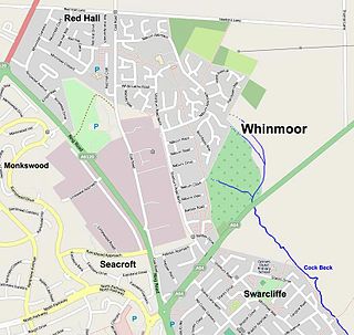
Whinmoor is a residential area of east Leeds, West Yorkshire, England.

<span class="mw-page-title-main">East End Park, Leeds</span> Area of Leeds, West Yorkshire, England

East End Park is an inner city area of east Leeds, West Yorkshire, England. It is situated between Burmantofts to the north west, Harehills to the north east, Halton Moor to the east, Richmond Hill to the west and Cross Green to the south west. It blends into the Halton Moor/Osmondthorpe area and is 1 mile to the east of Leeds city centre in the LS9 Leeds postcode area.

<span class="mw-page-title-main">Meanwood</span> Suburb of Leeds in West Yorkshire, England

Meanwood is a suburb and former village in north-west Leeds, West Yorkshire, England.

<span class="mw-page-title-main">Cross Gates</span> Suburb in east Leeds, West Yorkshire, England

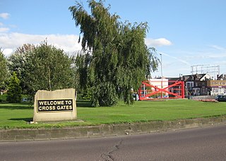
Cross Gates is a suburb in east Leeds, West Yorkshire, England.

<span class="mw-page-title-main">Colton, Leeds</span> Human settlement in England

Colton is a district of east Leeds, West Yorkshire, England, situated between Cross Gates to the north, Halton and Halton Moor to the west, Whitkirk to the north-west and Austhorpe to the north-east. Temple Newsam lies directly south of the estate.

<span class="mw-page-title-main">Richmond Hill, Leeds</span> Human settlement in England

Richmond Hill is a district of Leeds, West Yorkshire, England. The district lies a mile to the east of the city centre between York Road, East End Park and Cross Green. The appropriate City of Leeds ward is Burmantofts and Richmond Hill.

<span class="mw-page-title-main">Killingbeck</span> District of Leeds, West Yorkshire, England

Killingbeck is a district of east Leeds, West Yorkshire, England that is situated between Seacroft to the north, Cross Gates and Whitkirk to the east, Gipton to the west, Halton Moor to the south, Halton to the south-east and Osmondthorpe to the south-west.

<span class="mw-page-title-main">Halton Moor</span> District of Leeds, West Yorkshire, England

Halton Moor is a district of east Leeds, West Yorkshire, England, about three miles east of Leeds city centre close to the A63. It is situated between Killingbeck to the north, Temple Newsam to the south, Osmondthorpe to the west and Halton and Colton to the east.

<span class="mw-page-title-main">Temple Moor High School</span> Academy in Leeds, West Yorkshire, England

Temple Moor High School is a coeducational secondary school and sixth form located in Leeds, West Yorkshire, England. In recent years, it has received 'Science College' status. In 2017 an Ofsted inspection gave the school a Good rating.

<span class="mw-page-title-main">Osmondthorpe</span> District of east Leeds, West Yorkshire, England

Osmondthorpe a district of east Leeds in West Yorkshire, England is considered part of the Halton Moor district.

<span class="mw-page-title-main">Swarcliffe</span> Area of the City of Leeds, West Yorkshire, England

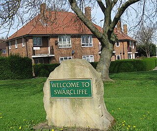
Swarcliffe, originally the Swarcliffe Estate, is a district of Leeds, West Yorkshire, England. It is 4.9 miles (8 km) east of Leeds city centre, and within the LS14 and LS15 Leeds postcode area. The district falls within the Cross Gates and Whinmoor ward of the Leeds Metropolitan Council.

<span class="mw-page-title-main">Temple Newsam (ward)</span> Electoral ward in Leeds, England

Temple Newsam is an electoral ward of Leeds City Council in east Leeds, West Yorkshire, covering the outer city suburbs of Colton, Halton, Halton Moor and Whitkirk. Austhorpe is also shared with Cross Gates and Whinmoor ward, whilst the current civil parish boundaries of Austhorpe see its eastern half lie in the western tip of Garforth and Swillington ward.

Temple Newsam is a ward in the metropolitan borough of the City of Leeds, West Yorkshire, England. It contains 51 listed buildings that are recorded in the National Heritage List for England. Of these, two are listed at Grade I, the highest of the three grades, three are at Grade II*, the middle grade, and the others are at Grade II, the lowest grade. The ward is to the east of the centre of Leeds, it is largely residential, and contains the suburbs of Colton, Halton, Halton Moor and Whitkirk. The most important building in the ward is Temple Newsam House, which is listed, together with associated structures and buildings in the surrounding park. Most of the other listed buildings are houses, cottages and associated structures, farmhouses and farm buildings. The rest include churches and associated structures, a former windmill and mill buildings, two railway bridges, and a school.

References

  1. Ekwall, Eilert (1960). The concise Oxford dictionary of English place-names (4 ed.). Oxford: Clarendon Press. p. 514. ISBN   0-19-869103-3.
  2. "Whitkirk Conservation Area Appraisal" (PDF). leeds.gov.uk. 13 March 2009. p. 5. Retrieved 6 March 2017.
  3. "History of Whitkirk – St Mary's Church, Whitkirk". whitkirkchurch.org.uk. Retrieved 6 March 2017.
  4. "History of Whitkirk, in Leeds and Yorkshire | Map and description". www.visionofbritain.org.uk. Retrieved 6 March 2017.
  5. "Welcome to Whitkirk Cricket Club". www.whitkirkcc.org.uk. Retrieved 6 March 2017.
  6. "Whitkirk Primary School - Templegate Walk, Leeds, LS15 0EU". www.whitkirk.org. Retrieved 6 March 2017.
  7. "Templenewsam Halton Primary School - Home". www.templenewsam.leeds.dbprimary.com. Retrieved 6 March 2017.
  8. "Temple Moor High School; Together we achieve success". tmhs.co.uk. Retrieved 6 March 2017.