Armley is a district in the west of Leeds, West Yorkshire, England. It starts less than 1 mile (1.6 km) from Leeds city centre. Like much of Leeds, Armley grew in the Industrial Revolution and had several mills, one of which houses now the Leeds Industrial Museum at Armley Mills. Armley is predominantly and historically a largely working class area of the city, still retains many smaller industrial businesses, and has many rows of back-to-back terraced houses.

Bramley is a district in west Leeds, West Yorkshire, England. It is part of the City of Leeds Ward of Bramley and Stanningley with a population of 21,334 at the 2011 Census. The area is an old industrial area with much 19th century architecture and 20th century council housing in the east and private suburban housing in the west.

Leeds West is a borough constituency in the city of Leeds, West Yorkshire which is represented in the House of Commons of the Parliament of the United Kingdom. It elects one Member of Parliament (MP) by the first-past-the-post system of election. The current MP is Rachel Reeves of the Labour Party — it has been a Labour seat since 1945. She is currently the Shadow Chancellor of the Duchy of Lancaster and Shadow Minister for the Cabinet Office.

Stanningley is a district of Pudsey, West Yorkshire, England. It is situated approximately 5 miles (8 km) west of Leeds city centre on the A647 road, the original main road from Leeds to Bradford. The appropriate Leeds Metropolitan Ward is Bramley and Stanningley. The parish is part of the Anglican Diocese of Leeds.

Benjamin Gott was one of the leading figures in the industrial revolution, in the field of textiles. His factory at Armley Mills, Armley, Leeds, was once the largest factory in the world and is now home to the Leeds Industrial Museum at Armley Mills.

The Leeds Industrial Museum at Armley Mills is a museum of industrial heritage located in Armley, near Leeds, in West Yorkshire, Northern England. The museum includes collections of textile machinery, railway equipment and heavy engineering amongst others.
There are 212 Grade II* listed buildings in Bristol, England.
Edward Alfred Briscoe Drury was an English architectural sculptor and artist active in the New Sculpture movement. During a long career Drury created a great number of decorative figures such as busts and statuettes plus larger monuments, war memorials, statues of royalty and architectural pieces. During the opening years of the 20th-century he was among the foremost architectural sculptors active in Britain and in that period created the series of works in central London for which he is perhaps now best known. These include the figures on the Old War Office building in Whitehall, elements of the facade of the Victoria and Albert Museum and four of the colossal statues on Vauxhall Bridge.

St Bartholomew’s Church, Armley is a parish church in the Church of England in Armley, West Yorkshire. The church is one of two Church of England churches in Armley; the other being Christ Church. Worship at St Bartholomew's is firmly rooted in the Anglo-Catholic tradition of the Church of England with a solemn mass being celebrated weekly.

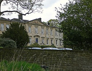
Gotts Park Mansion, formerly known as Armley House, is a Grade II listed country house in Armley Park, 3 miles from Leeds city centre. Formerly the home of industrialist Benjamin Gott, it is now the home of Gotts Park Golf Club.
Bolton and Undercliffe is a ward in the metropolitan borough of the City of Bradford, West Yorkshire, England. It contains 20 listed buildings that are recorded in the National Heritage List for England. All the listed buildings are designated at Grade II, the lowest of the three grades, which is applied to "buildings of national importance and special interest". The ward is a suburb of Bradford to the northeast of the city centre and is almost completely residential. It includes Peel Park which contains listed buildings, including the entrance lodges, statues, drinking fountains, and a relocated doorway and wall. The other listed buildings include houses and cottages, farmhouses and farm buildings, a church, and a school.
Calverley and Farsley is a ward in the metropolitan borough of the City of Leeds, West Yorkshire, England. It contains 49 listed buildings that are recorded in the National Heritage List for England. Of these, one is listed at Grade I, the highest of the three grades, two are at Grade II*, the middle grade, and the others are at Grade II, the lowest grade. The ward contains the town of Farsley with the district of Stanningley to the south, the villages of Calverley and Rodley in the north of the ward, and the surrounding area. Most of the listed buildings are houses, cottages and associated structures, farmhouses and farm buildings. The Leeds and Liverpool Canal passes through the ward and the listed buildings associated with it are two swing bridges and warehouses. The other listed buildings include churches, chapels and items in churchyards, public houses, a bridge over the River Aire, a mill building, schools, and two war memorials.
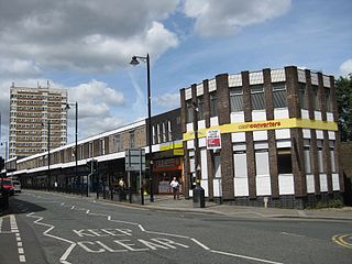
Armley is a ward in the metropolitan borough of the City of Leeds, West Yorkshire, England. It contains 49 listed buildings that are recorded in the National Heritage List for England. Of these, five are listed at Grade II*, the middle of the three grades, and the others are at Grade II, the lowest grade. The ward contains the former Armley Mills, later the Leeds Industrial Museum at Armley Mills, Armley Prison, Armley Park, and Armley Cemetery, all of which contain listed buildings. The Leeds and Liverpool Canal passes through the ward, and three bridges crossing it are listed. The other listed buildings include a former country house, smaller houses, cottages and associated structures, another former textile mill, public houses, churches and associated structures, schools, and a public library.
Field House, Sowerby is a Grade II* listed privately owned historic house in Sowerby Bridge, West Yorkshire, England.
Bramley and Stanningley is a ward in the metropolitan borough of the City of Leeds, West Yorkshire, England. It contains 37 listed buildings that are recorded in the National Heritage List for England. All the listed buildings are designated at Grade II, the lowest of the three grades, which is applied to "buildings of national importance and special interest". The ward is to the northwest of the centre of Leeds, and includes the areas of Bramley, Moorside, Rodley, Stanningley, and Whitecote. Most of the listed buildings are houses, cottages and associated structures. The Leeds and Liverpool Canal runs through the ward, and the listed buildings associated with it are two locks and two bridges crossing it. The other listed buildings include churches and associated structures, public houses, a retaining wall retaining items involved in the early supply of water to the area, schools, a former bank, and public swimming baths.
Headingley is a ward in the metropolitan borough of the City of Leeds, West Yorkshire, England. It contains 111 listed buildings that are recorded in the National Heritage List for England. Of these, two are listed at Grade II*, the middle of the three grades, and the others are at Grade II, the lowest grade. The ward is to the northwest of the centre of Leeds, and is largely residential. As Leeds became more prosperous in the 19th century, the area developed to become "the prime residential area of Leeds". Most of the listed buildings are houses and associated structures, many of the houses are large, and some were used later for other purposes. The other listed buildings include churches and associated structures, public houses, remaining structures from the Leeds Zoological and Botanical Gardens, a cinema and lamp post, a war memorial, and a group of telephone kiosks.
Hyde Park and Woodhouse are areas in the metropolitan borough of the City of Leeds, West Yorkshire, England. The areas contain 146 listed buildings that are recorded in the National Heritage List for England. Of these, five are listed at Grade II*, the middle of the three grades, and the others are at Grade II, the lowest grade. The areas are largely residential, and also contain the University of Leeds. Many of the university buildings are listed, some of which are newly built, and others have been converted from pre-existing buildings. Most of the other listed buildings are houses and associated structures, and the rest include churches and memorials in churchyards, a public house, statues and other memorials, buildings in the former Woodhouse Cemetery, schools and associated structures, a cross, and public buildings.
Ledston is a civil parish in the metropolitan borough of the City of Leeds, West Yorkshire, England. It contains 20 listed buildings that are recorded in the National Heritage List for England. Of these, four are listed at Grade I, the highest of the three grades, two are at Grade II*, the middle grade, and the others are at Grade II, the lowest grade. The parish contains the village of Ledston and the surrounding countryside. The most important building in the parish is Ledston Hall, which is listed, together with a number of associated structures. The other listed buildings are a farmhouse, farm buildings, two mileposts, and two former winding houses at a colliery that has closed.
William Gott, was a British wool merchant, mill owner, philanthropist and art collector from Leeds, West Riding of Yorkshire, England.


