Bramhope

Last updated

Bramhope
Bramhope 034.jpg
Bramhope crossroads
Leeds UK location map.svg
Red pog.svg
Bramhope
West Yorkshire UK location map.svg
Red pog.svg
Bramhope
Location within West Yorkshire
Population3,400  [1]
OS grid reference SE253432
  London 175 mi (282 km)  SSE
Civil parish
  • Bramhope
Metropolitan borough
Metropolitan county
Region
Country England
Sovereign state United Kingdom
Post town LEEDS
Postcode district LS16
Dialling code 0113
Police West Yorkshire
Fire West Yorkshire
Ambulance Yorkshire
UK Parliament
List of places
UK
England
Yorkshire
53°52′58″N1°36′34″W / 53.8829°N 1.6095°W / 53.8829; -1.6095 Coordinates: 53°52′58″N1°36′34″W / 53.8829°N 1.6095°W / 53.8829; -1.6095

Bramhope is a village and civil parish in the City of Leeds metropolitan borough, West Yorkshire, England, north of Holt Park and north east of Cookridge.

Contents

The village is 9 miles (14 km) north of Leeds city centre and it is in the LS16 Leeds postcode area. According to the 2001 census the parish had a population of 3,400. [1] The population had increased to 3,533 at the 2011 Census. [2] It is predominantly made up of large, privately owned houses which tend to be above the average value for properties in West Yorkshire.

Bramhope sits in the Leeds North West constituency and the Adel & Wharfedale ward of Leeds City Council.

Etymology

The place-name Bramhope appears first in the Domesday Book of 1086 as Brahop and Bramhop, with later medieval spellings including Bramhop(a) and Bramhop(p)e. The name seems to derive from the Old English words brōm 'broom' and hōp 'a small valley, side-valley off a larger valley', here referring to a small valley off Wharfedale, [3] probably the one through which flows Bramhope Beck. [4]

History

Town well Bramhope 021.jpg
Town well

The earliest known settlement in the area was a British camp established off Moor Road. The Romans built a road through the area from Adel to Ilkley, traces of which remain in a field near Leeds Bradford Airport. [5]

In 1086, Bramhope was the manor of an Anglo-Saxon thegn, Uchill. In 1095 the manor passed to the Percy family, and in 1165 was sold to Ralph de Bramhope. In the 13th century the monasteries owned much of the land and had granges where sheep were grazed. The monks used tracks, such as Scotland Lane and Staircase Lane, as they travelled from their outlying granges to Kirkstall Abbey. [5]

The village had a small population until the 20th century. The Black Death of 1348-49 reduced the number of adults to 34, but this gradually increased to about 400 in 1900. Now it is approximately 3,400. [5] Water was drawn from private wells or the town well at the foot of Northgate (now Church Hill). The town well was restored in 1991 by the Bramhope History Group, and is located opposite St Giles' Church. [5] The plaque says that the well was exposed in 1991, so perhaps it had been lost for some time. [6]

Churches

Puritan Chapel, 1649 Bramhope 006.jpg
Puritan Chapel, 1649

At the Dissolution of the Monasteries Henry VIII gave the land to the Earl of Cumberland. In the 16th century the Dyneley family moved into the area and acquired Bramhope Hall. In 1649 they built the Puritan Chapel, which was taken over by the Church of England after the Restoration. [5] The chapel is one of only a few built during the Commonwealth period. It is said not to have been consecrated but nevertheless was regularly used for church services until 1881–82. The Puritan Chapel was listed Grade I in 1966.

When the chapel proved too small for the growing population, St Giles' Church was built in 1881. [7] The original Methodist chapel was built in 1837 and replaced by the much bigger church in 1896. [5] [8] There is a map showing the location of St Giles and the Methodist church here. Bramhope Cemetery, established in 1861, is in Moor Road, [9] but there are still some historical gravestones remaining in the cemetery of the Puritan Chapel.

Road and railway

Milestone near St Giles' Church Bramhope 018.jpg
Milestone near St Giles' Church

For many centuries travellers to the market towns in the vicinity used Otley Old Road. However, it was the Leeds to Otley turnpike road, with its tollhouses, opened in 1842, which routed travellers through the outskirts of Bramhope. It is along this route that motorists today travel between Leeds and the northwest. The milestones along the road were erected in 1850. [5]

The railway was excavated under the village through the Bramhope Tunnel constructed between 1845 and 1849. The tunnel has an elaborate castellated northern entrance and there are many heaps of spoil and several ventilation shafts along its length. There is a replica of the tunnel entrance in Otley churchyard, erected as a memorial to the 24 men who lost their lives during the tunnel's construction. [5] A railway station has never been built at or near Bramhope.

Schools

A village school was built in Eastgate where the war memorial garden is situated. A plaque states "On this site in 1790 a Day School was erected by the freeholders and copyholders of Bramhope Township. It was also used as a Sunday School and Public Meeting Place. Demolished 1961". The school became overcrowded whilst tunnelling work for the railway was going on in the late 1840s. It was replaced by a larger building in 1873 in Breary Lane, next to the shopping parade. The present school, situated on Tredgold Crescent, was opened in 1961. [5]

Community

Robert Craven Memorial Hall Robert Craven Memorial Hall Bramhope.jpg
Robert Craven Memorial Hall

Bramhope has a Round Table, which organises activities to raise money for charity. [10] Bramhope has a cricket club which plays at the Recreation Ground on Old Lane. The club plays in the Leeds and Wetherby Cricket League and has two senior teams. [11]

Memorial Hall

Robert Craven Memorial Hall (originally the Craven Institute, 1896) was part of the bequest of Robert Craven, a local farmer. It is now the village hall and administered as a registered charity. It has a crown bowling green, car park and tennis courts. Inside there are various rooms plus a large hall with stage, which doubles as a badminton court. [12] On the second Saturday of every month a farmer's market is hosted at this hall. [13] The memorial hall also hosts a yearly flower show in the autumn, [14] and a bridge club. [15]

Bramhope Scout Campsite

The 13-acre Bramhope Scout Campsite, to the west of the village, is owned by Central Yorkshire Scouts. [16]

Listed buildings

Old weaver's cottage, now private residence Bramhope 029.jpg
Old weaver's cottage, now private residence

Notable people

Location grid

See also

Related Research Articles

Otley Market town and civil parish in West Yorkshire, England

Otley is a market town and civil parish at a bridging point on the River Wharfe, in the City of Leeds metropolitan borough in West Yorkshire, England. Historically a part of the West Riding of Yorkshire, the population was 13,668 at the 2011 census. It is in two parts: south of the river is the historic town of Otley and to the north is Newall, which was formerly a separate township. The town is in lower Wharfedale on the A660 road which connects it to Leeds.

Arthington Village and civil parish in Leeds, West Yorkshire, England

Arthington is a small village in Wharfedale, in the City of Leeds metropolitan borough in West Yorkshire, England. It is a civil parish which, according to the 2011 census, had a population of 532 and is in the LS21 postcode district with Otley as its post town. It is in the Otley ward of the City of Leeds, and the Leeds North West parliamentary constituency.

Headingley Human settlement in England

Headingley is a suburb of Leeds, West Yorkshire, England, approximately two miles out of the city centre, to the north west along the A660 road. Headingley is the location of the Beckett Park campus of Leeds Beckett University and Headingley Stadium.

Cookridge Suburb of Leeds in West Yorkshire, England

Cookridge is a suburb of north-west Leeds, West Yorkshire, England, north of the Leeds Outer Ring Road. In 1715 Ralph Thoresby described it as a village four miles from Leeds and three from Otley, dating from 1540.

Adel, Leeds Suburb of Leeds in West Yorkshire, England

Adel is a suburb of Leeds, West Yorkshire, England. To its immediate south is Weetwood, to the west are Cookridge and Holt Park, to the east are Alwoodley and Moortown, and to the north are Bramhope, Arthington and Eccup.

A660 road

The A660 is a major road in the Leeds and Bradford districts of West Yorkshire, England that runs from Leeds city centre to Burley-in-Wharfedale where it meets the A65. The A660 is approximately 10 miles (16 km) long, and crosses the watershed from Airedale to lower Wharfedale. For most of its length the road is in the metropolitan district of the City of Leeds; the last 0.4 miles (0.6 km) is in City of Bradford district.
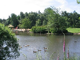
Bramhope Tunnel Railway tunnel in West Yorkshire, England

Bramhope Tunnel is on the Harrogate Line between Horsforth station and the Arthington Viaduct in West Yorkshire, England. Services through the railway tunnel are operated mainly by Northern. The tunnel was constructed during 1845–1849 by the Leeds and Thirsk Railway. It is notable for its 2.138-mile (3.441 km) length and its Grade II listed, crenellated north portal. The deaths of 24 men who were killed during its construction are commemorated in Otley churchyard by a monument that is a replica of the tunnel's north portal.

Breary Marsh Nature reserve in Leeds, West Yorkshire, England

Breary Marsh is a Local Nature Reserve and Site of Special Scientific Interest situated adjacent to Golden Acre Park in Leeds, West Yorkshire, England, grid reference SE264416.

Grade I listed churches in West Yorkshire

West Yorkshire is a metropolitan county in the Yorkshire and the Humber region of England. Created as a metropolitan county in 1974 after the passage of the Local Government Act 1972, it consists of five metropolitan boroughs, namely the City of Bradford, Calderdale, Kirklees, the City of Leeds and the City of Wakefield. Its area corresponds approximately with the historic West Riding of Yorkshire, and it contains the major towns of Bradford, Dewsbury, Halifax, Huddersfield, Leeds, and Wakefield.

All Saints Church, Otley Church in West Yorkshire, England

All Saints' Church in Otley, West Yorkshire, England is an active Anglican parish church in the archdeaconry of Leeds and the Diocese of Leeds.

Otley is a civil parish in the metropolitan borough of the City of Leeds, West Yorkshire, England. It contains 152 listed buildings that are recorded in the National Heritage List for England. Of these, one is listed at Grade I, the highest of the three grades, two are at Grade II*, the middle grade, and the others are at Grade II, the lowest grade. The parish contains the market town of Otley and the surrounding countryside. Most of the listed buildings are in the town, and consist of houses, cottages and associated structures, shops, public houses, and commercial buildings. The other listed buildings include churches, chapels and items in churchyards, farmhouses and farm buildings, buildings associated with a former mill, public buildings, schools, milestones, former workhouse buildings, a clock tower, a war memorial and garden, and telephone kiosks.

Wetherby is a civil parish in the metropolitan borough of the City of Leeds, West Yorkshire, England. The parish contains 33 listed buildings that are recorded in the National Heritage List for England. All the listed buildings are designated at Grade II, the lowest of the three grades, which is applied to "buildings of national importance and special interest". The parish contains the town of Wetherby and the surrounding area. The listed buildings include houses and associated structures, road and railway bridges, churches, public houses, a bath house, former farm buildings, a town hall, a former railway engine shed, and two mileposts.

Guiseley and Rawdon is a ward in the metropolitan borough and Rawdon is a civil parish in the City of Leeds, West Yorkshire, England. This list also contains the listed buildings in Otley and Yeadon ward. The wards and parish contain 99 listed buildings that are recorded in the National Heritage List for England. Of these, one is listed at Grade I, the highest of the three grades, three are at Grade II*, the middle grade, and the others are at Grade II, the lowest grade. The wards and parish contain the towns of Guiseley and Yeadon, the villages of Rawdon and Hawksworth, and the surrounding area. Most of the listed buildings are houses, cottages and associated structures, farmhouses and farm buildings. The other listed buildings include churches and items in churchyards, a village cross, a school, a former hospital, a railway bridge, a railway tunnel portal and retaining walls, a former tram shed, a town hall, and a telephone kiosk.

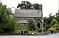
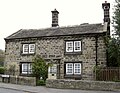
Bramhope is a civil parish in the metropolitan borough of the City of Leeds, West Yorkshire, England. It contains 20 listed buildings that are recorded in the National Heritage List for England. Of these, one is listed at Grade I, the highest of the three grades, and the others are at Grade II, the lowest grade. The parish contains the village of Bramhope and the surrounding countryside. Of the listed buildings, nine are mileposts, and the others include houses, farmhouses and farm buildings, a chapel and a church, the north portal of Bramhope Tunnel and a sighting tower used in the construction of the tunnel, and a gazebo.

Garforth and Swillington is a ward and Swillington is a civil parish in the metropolitan borough of the City of Leeds, West Yorkshire, England. The ward and parish contain 23 listed buildings that are recorded in the National Heritage List for England. Of these, two are listed at Grade II*, the middle of the three grades, and the others are at Grade II, the lowest grade. The area covered by the list includes the town of Garforth, the village of Swillington, and the surrounding countryside. The listed buildings include houses and associated structures, farmhouses, churches, a sundial in a churchyard, road and railway bridges, and mileposts.

Aberford and Lotherton cum Aberford are adjacent civil parishes in the metropolitan borough of the City of Leeds, West Yorkshire, England. The parishes contain 25 listed buildings that are recorded in the National Heritage List for England. Of these, one is listed at Grade II*, the middle of the three grades, and the others are at Grade II, the lowest grade. The parishes contain the village of Aberford and the surrounding countryside, including the area around Lotherton Hall. Most of the listed buildings are houses and cottages, and the others include churches, a market cross, a former water mill and a former windmill, a bridge, farm buildings, a hotel and a former stable block, a war memorial, and three milestones.

Pool is a civil parish in the metropolitan borough of the City of Leeds, West Yorkshire, England. The parish contains twelve listed buildings that are recorded in the National Heritage List for England. All the listed buildings are designated at Grade II, the lowest of the three grades, which is applied to "buildings of national importance and special interest". The parish contains the village of Pool-in-Wharfedale and the surrounding countryside. Most of the listed buildings are houses and cottages, and the others include a church, a former toll house, a bridge, three mileposts, and a war memorial.

Scarcroft is a civil parish in the metropolitan borough of the City of Leeds, West Yorkshire, England. The parish contains eight listed buildings that are recorded in the National Heritage List for England. All the listed buildings are designated at Grade II, the lowest of the three grades, which is applied to "buildings of national importance and special interest". The parish contains the village of Scarcroft and the surrounding countryside, and the listed buildings consist of houses, a former toll house, and three milestones.

Ackworth is a civil parish in the metropolitan borough of the City of Wakefield, West Yorkshire, England. The parish contains 36 listed buildings that are recorded in the National Heritage List for England. Of these, one is listed at Grade I, the highest of the three grades, four are at Grade II*, the middle grade, and the others are at Grade II, the lowest grade. The parish contains the settlements of High Ackworth, Low Ackworth, Ackworth Moor Top, and part of East Hardwick, and the surrounding countryside. Most of the listed buildings are houses, cottages and associated structures. The other listed buildings include a church and items in the churchyard, a plague stone or cross base, a village cross, former almshouses, a school and an associated Quaker meeting house, three guide posts, and two mileposts,

References

  1. 1 2 "Parish Headcounts, 2001" Archived 13 June 2011 at the Wayback Machine , Bramhope CP (Parish), Office for National Statistics. Retrieved 17 March 2015
  2. "Civil Parish population 2011". Neighbourhood Statistics. Office for National Statistics. Retrieved 25 February 2016.
  3. Victor Watts (ed.), The Cambridge Dictionary of English Place-Names, Based on the Collections of the English Place-Name Society (Cambridge: Cambridge University Press, 2004), s.v. BRAMHOPE.
  4. Harry Parkin, Your City's Place-Names: Leeds, English Place-Name Society City-Names Series, 3 (Nottingham: English Place-Name Society, 2017), p. 27.
  5. 1 2 3 4 5 6 7 8 9 "Bramhope and Carlton Parish Council". A Brief History of Bramhope (source:A History of the Township of Bramhope' by W.F. Seals). 10 October 2000. Archived from the original on 30 December 2009. Retrieved 14 July 2009.
  6. Hatton, Gordon (19 January 2009). "Geograph.org.uk". Photo of Old Well, Bramhope, and comments. Retrieved 14 July 2009.
  7. "St Giles Bramhope". St Giles Church website. 2009. Retrieved 14 July 2009.
  8. "Bramhope Methodist Church". Bramhope Methodist Church website. 2009. Archived from the original on 22 May 2009. Retrieved 14 July 2009.
  9. "Bramhope and Carlton Parish Council". Bramhope Cemetery. 2005. Archived from the original on 9 May 2008. Retrieved 14 July 2009.
  10. "bramhope844.co.uk". Bramhope Round Table. 2009. Archived from the original on 11 September 2011. Retrieved 14 July 2009.
  11. "Headingley Bramhope CC". Headingley Bramhope Cricket Club. 2020. Retrieved 15 January 2020.
  12. Firth, Graham (2001). "Bramhope Parish Council". The Robert Craven Memorial Hall. Retrieved 14 July 2009.
  13. "Bramhope Parish Council". Farmers Market. 2008. Retrieved 14 July 2009.
  14. "Bramhope Parish Council". Bramhope flower show. 2009. Retrieved 14 July 2009.
  15. "gfirth.plus.com". Bramhope Bridge Club. 2009. Archived from the original on 10 May 2008. Retrieved 14 July 2009.
  16. "Bramhope Scout Campsite". Central Yorkshire Scouts. Retrieved 20 July 2018.
  17. Historic England. "Puritan Chapel, Otley Road (north side) (1261799)". National Heritage List for England . Retrieved 14 July 2009.
  18. Historic England. "Farmhouse, 1 Church Hill (1253371)". National Heritage List for England . Retrieved 14 July 2009.
  19. Historic England. "Barn approx 5 metres west of Old Manor Farmhouse (1253372)". National Heritage List for England . Retrieved 14 July 2009.
  20. Historic England. "Old Manor Farmhouse (rear portion only) (1261835)". National Heritage List for England . Retrieved 14 July 2009.
  21. Historic England. "Weaver's Cottage, 4 Eastgate (1261836)". National Heritage List for England . Retrieved 14 July 2009.
  22. Historic England. "Methodist church, Eastgate, north side (1253373)". National Heritage List for England . Retrieved 14 July 2009.
  23. Historic England. "Gazebo on northwest corner of garden of Westwood, Hall drive (1253374)". National Heritage List for England . Retrieved 14 July 2009.
  24. Historic England. "Manor House, Manor Close (north side) (1253375)". National Heritage List for England . Retrieved 14 July 2009.
  25. Historic England. "Sighting tower, south side of Moorland Road (1253379)". National Heritage List for England . Retrieved 14 July 2009.
  26. Historic England. "The Hollies, Old Lane, north side (1253380)". National Heritage List for England . Retrieved 14 July 2009.
  27. Historic England. "Portal to north entrance to Bramhope railway tunnel (1253370)". National Heritage List for England . Retrieved 14 July 2009.
  28. Historic England. "Milestone at Church Hill and Ditley Road junction (1261800)". National Heritage List for England . Retrieved 14 July 2009.
  29. Historic England. "Milepost at SE 240 441, Otley Road (north side) (1253381)". National Heritage List for England . Retrieved 14 July 2009.
  30. Historic England. "Milepost at SE 253 432, Otley Road (north side) (1253384)". National Heritage List for England . Retrieved 14 July 2009.
  31. Historic England. "Milepost at SE 264 421, Otley Road (north side) (1253387)". National Heritage List for England . Retrieved 14 July 2009.
  32. Historic England. "Milepost on east corner of junction with Breary Lane at SE 255 430, Otley Road (south side) (1253385)". National Heritage List for England . Retrieved 14 July 2009.
  33. Historic England. "Milepost on east corner of junction with Breary lane east at SE 256 430, Otley road (north side) (1253386)". National Heritage List for England . Retrieved 14 July 2009.
  34. Historic England. "Milepost on south-east corner of junction with Pool Bank New Road at SE 241 440, Otley Road (south side) (1253382)". National Heritage List for England . Retrieved 14 July 2009.
  35. Historic England. "Milepost on south-west corner of junction with Pool Bank New Road st SE 241440, Otley Road (south side) (1261798)". National Heritage List for England . Retrieved 14 July 2009.
  36. Historic England. "Milepost on west corner of junction with Creskeld Lane at SE 258 428, Otley Road (north side) (1261801)". National Heritage List for England . Retrieved 14 July 2009.
  37. Historic England. "Memorial to victims of Bramhope tunnel disaster, Church Lane (north side), Otley. (1135240)". National Heritage List for England . Retrieved 14 July 2009.
  38. "Brownlee postbox row hits Leeds suburbs". BBC News. 10 August 2012. Retrieved 23 December 2015.