Oakwood, Leeds

Last updated

Oakwood
Oakwood-clock-tower.jpg
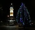
The Oakwood Clock tower following restoration. 2015.
Leeds UK location map.svg
Red pog.svg
Oakwood
West Yorkshire UK location map.svg
Red pog.svg
Oakwood
Location within West Yorkshire
Metropolitan borough
Metropolitan county
Region
Country England
Sovereign state United Kingdom
Post town LEEDS
Postcode district LS8
Dialling code 0113
Police West Yorkshire
Fire West Yorkshire
Ambulance Yorkshire
UK Parliament
List of places
UK
England
Yorkshire
53°49′37″N1°30′18″W / 53.827°N 1.505°W / 53.827; -1.505 Coordinates: 53°49′37″N1°30′18″W / 53.827°N 1.505°W / 53.827; -1.505

Oakwood is a suburb of north-east Leeds, West Yorkshire, England, that lies between Gipton and Roundhay Park.

Contents

The suburb lies within the LS8 postcode and sits within both the Roundhay ward of Leeds City Council and Leeds North East parliamentary constituency.

Etymology

The name itself has fairly simple roots, merely referring to the species of tree, though the usage of the name for the suburb can be attributed to Oakwood House, a stately home that has since been renovated and turned into a retirement home called Sabourn Court. [1]

History

Roundhay Estate and Oakwood House

What is now Oakwood was originally a small rural area part of the greater Roundhay estate on the fringes of Roundhay Park and was owned by George Goodman. Oakwood was part of the Leeds Rural District, a district containing the then growing estates of Roundhay and Seacroft, and was heavily tied to the city of Leeds. The land was sold by Goodman in 1825 to a local wealthy wool merchant family. Soon after the land purchase, Oakwood House had begun construction under the name of Wood End. It is not known exactly when the house started construction but maps show between 1825 and 1847. [2] The house would change hands multiple times between 1847 and 1865 when it was sold to the Hudson family, who dropped the Wood End name and settled on Oakwood House. By 1867 the house would stop being advertised and surveyed as part of Roundhay as the name Oakwood had also begun to be used for the land surrounding the house. In 1891 much of the land was put up for sale as the Oakwood Building Estate and would form the basis for Oakwood as a settlement. [3]

Oakwood Parade in 1909 Oakwood Parade 1909.jpg
Oakwood Parade in 1909

Development and Growth

The Oakwood Building Estate had led to the creation of Oakwood Parade, a series of terraced buildings extending down modern day Roundhay Road with the first four buildings being completed in 1894. The full parade would not be completed until the 1920s. [4] The oldest continuously occupied shop on the Parade is the Fish Bar, a Grade II Listed Building with an Art Deco frontage of black glass panels, which has been selling fish and chips since 1934. [3]

Possibly the most recognisable feature of Oakwood is its clock tower. Oakwood Clock, is a small clock tower that was built in 1904 by Potts of Leeds to the design of Leeming and Leeming and is sited at the bottom end of Roundhay Park; it was first designed as the centrepiece of Kirkgate Market, Leeds. After the design of Kirkgate Market was revised it was considered that this clock would no longer be suitable for the building, and the idea to place it in Oakwood came about. Eight years after it was first built this clock was erected in Oakwood. [5] In early 2015, the tower was replaced, with the original clock being kept. [6]

Roundhay Garden Scene

Although credited as having taken place in Roundhay, It was in the garden of Oakwood Grange that Louis Le Prince filmed the Roundhay Garden Scene in 1888, credited as the first motion picture. [7] Oakwood Grange was demolished in 1972 to make way for Oakwood Grange housing estate [8] but the adjacent stately home, Oakwood Hall, still remains as a nursing home. [9]

Plaque for the Oakwood Clock OakwoodClockPlaque.jpg
Plaque for the Oakwood Clock

Amenities

On Roundhay Road is the Post Office, a supermarket, currently Home Bargains (formerly Netto, Co-op, Somerfield and Safeway) and several shops and banks. Further down from the Oakwood Boundary is Tesco. Oakwood Library sits on the corner of the junction diagonally opposite the Oakwood clock.

Oakwood Farmers' Market

Held on the third Saturday of the month since 15 March 2008 around the Oakwood Clock, Oakwood Farmers' Market has become a regular feature. Organised by local residents in conjunction with Roundhay Environmental Action Project [10] the Oakwood Farmers' Market's goal is to provide quality local produce, some of which is organic, with local being defined at produce travelling no more than 20 mi to the market. [11] Receiving FARMA accreditation, being the second farmers' market in Leeds to have done so, has meant that the Oakwood Farmers' Market can display the FARMA logo to prove its status as a true farmers' market. [12] Regular stalls and 'feature' stalls provide a range of local products including: jams, meats, eggs, chocolates, bread and wide range of locally grown fruits and vegetables. [11] Seasonal holidays are celebrated with local musicians, artists and performers.

Associated areas and boundaries

While the A58 Easterly Road is often used to denote the border between Oakwood and Gipton, as seen with the city council wards and the constituencies, Oakwood does not officially have any boundaries. Because the LS8 postcode boundary includes Fearnville, Gipton and Harehills, they are sometimes considered part of or heavily linked with Oakwood. A major example of this is Oakwood Primary School, which bares the name yet sits firmly within Gipton.

Despite being two separate areas, Roundhay is the name of the council ward and as such some areas within Oakwood, such as the Post Office and Tesco, refer to themselves as part of Roundhay rather than Oakwood.

Gipton Wood

Gipton Wood from Roundhay Road GiptonWoodAugust09.jpg
Gipton Wood from Roundhay Road

Gipton Wood refers to either an area of woodland or an area of housing adjacent to the wood in Leeds. The woodland is now triangular, bounded by the Oakwood Boundary Road on the north-east, Roundhay Road on the west and Copgrove Road on the south-east. It is 8.2 ha and part of the Forest of Leeds. [13] It is an ancient woodland, previously housing a stone aged, bronze aged, and Roman settlement. [14] Trees are predominantly oak, sycamore, beech and hornbeam. It was given to the city in 1923 and is now maintained by the City of Leeds and a voluntary group, the Friends of Gipton Wood. [15] [16] The public house on the opposite side of the road was formerly called "The Gipton" but has now changed to "The Roundhay". [17]

The residential area known as Gipton Wood is south of the wood down to Easterly Road.

Location grid

See also

Related Research Articles

<span class="mw-page-title-main">Moortown, Leeds</span> Suburb of Leeds in West Yorkshire, England

Moortown is an affluent suburb of Leeds, West Yorkshire, England in the LS17 and LS8 postcode district. It is a civil parish and sits in the Moortown ward of Leeds City Council in the north east of the city.

<span class="mw-page-title-main">Harehills</span> Area of Leeds, West Yorkshire, England

Harehills is an inner-city area of east Leeds, West Yorkshire, England. It is approximately 1 mile (1.6 km) north east of Leeds city centre. Harehills is situated between the A58 and the A64. It sits in the Gipton & Harehills ward of Leeds City Council and the Leeds East parliamentary constituency, between Burmantofts and Gipton, and adjacent to Chapeltown.

<span class="mw-page-title-main">Seacroft</span> Suburb of Leeds, West Yorkshire, England

Seacroft is an outer-city suburb/township consisting mainly of council estate housing covering an extensive area of east Leeds, West Yorkshire, England. It lies in the LS14 Leeds postcode area, around 4 miles (6.4 km) east of Leeds city centre.

<span class="mw-page-title-main">Roundhay</span> Suburb of Leeds, West Yorkshire, England

Roundhay is a large suburb in north-east Leeds, West Yorkshire, England. Roundhay had a population of 22,546 in 2011.

<span class="mw-page-title-main">Gipton</span> Human settlement in England

Gipton is a suburb of east Leeds, West Yorkshire, England, between the A58 to the north and the A64 to the south.

<span class="mw-page-title-main">Gledhow</span>

Gledhow is a suburb of north east Leeds, West Yorkshire, England, east of Chapel Allerton and west of Roundhay.

<span class="mw-page-title-main">Cookridge</span> Suburb of Leeds in West Yorkshire, England

Cookridge is a suburb of north-west Leeds, West Yorkshire, England, north of the Leeds Outer Ring Road. In 1715 Ralph Thoresby described it as a village four miles from Leeds and three from Otley, dating from 1540.

<span class="mw-page-title-main">West Park, Leeds</span> Human settlement in England

West Park is a suburb of north-west Leeds, West Yorkshire, England, north of Headingley. It is a mixed area of private suburban housing and suburban council estates. The name derives from its main park containing playing fields together with a conservation area of grassy meadow ending in woodland. The largest housing estate in West Park is Moor Grange.

<span class="mw-page-title-main">Meanwood</span> Suburb of Leeds in West Yorkshire, England

Meanwood is a suburb and former village in north-west Leeds, West Yorkshire, England.

<span class="mw-page-title-main">Ireland Wood</span>

Ireland Wood is a small residential area in north-west Leeds, West Yorkshire, England named after the Woodland Trust wood which it contains. It is approximately 4 miles (6.4 km) to the north-west of Leeds city centre. It was planned by Leeds Housing Director RAH Livett and won the Ministry Housing medal for 1945-9. An early plan of Ireland Wood in 1950 is shown on the Leodis website.

<span class="mw-page-title-main">Moor Grange</span> Human settlement in England

Moor Grange Estate is a housing estate in the West Park area of Leeds, West Yorkshire, England, which was built in the 1950s on reclaimed farmland. Work on the Moor Grange Estate began in 1955. It was originally owned by the local council, and was leased by the council to tenants as a council estate. Most of the housing on the estate is now privately owned. Moor Grange does not suffer the crime problems of other council estates. House prices on the estate are high, and Moor Grange is considered a 'model council estate'. This may be due to the affluence of the area in which it is situated. Moor Grange backs onto the smaller Spen Estate which is another council estate in West Park. The Estate falls within the Kirkstall ward of the Leeds Metropolitan Council.

<span class="mw-page-title-main">Shadwell, West Yorkshire</span> Village and civil parish in West Yorkshire, England

Shadwell is a village and civil parish in north-east Leeds, West Yorkshire, England. The village is 6 miles (9.7 km) to the north east of Leeds city centre.

<span class="mw-page-title-main">Richmond Hill, Leeds</span> Human settlement in England

Richmond Hill is a district of Leeds, West Yorkshire, England. The district lies a mile to the east of the city centre between York Road, East End Park and Cross Green. The appropriate City of Leeds ward is Burmantofts and Richmond Hill.

<span class="mw-page-title-main">Killingbeck</span> District of Leeds, West Yorkshire, England

Killingbeck is a district of east Leeds, West Yorkshire, England that is situated between Seacroft to the north, Cross Gates and Whitkirk to the east, Gipton to the west, Halton Moor to the south, Halton to the south-east and Osmondthorpe to the south-west.

<span class="mw-page-title-main">Moor Allerton</span>

Moor Allerton is an area of Leeds, West Yorkshire, England. The area is situated in North Leeds, near to King Lane and the Leeds Outer Ring Road.

<span class="mw-page-title-main">Fearnville</span> Human settlement in England

Fearnville is a small area of Leeds which has boundaries with Roundhay, Seacroft, Oakwood, Gipton and Harehills. Fearnville is commonly described as being part of Roundhay or Oakwood, although it is classed as being in the Killingbeck and Seacroft ward. Fearnville had a population of 3,654 in 2011.

<span class="mw-page-title-main">History of Seacroft</span>

Seacroft pre-dates the Domesday book, with evidence of a settlement in the area from the Neolithic Age. Seacroft remained largely unchanged for centuries as a small Yorkshire village, until in the 1950s the area was developed into Leeds' largest council estate. In the 1960s and 1970s the building of Whinmoor and Swarcliffe enclosed Seacroft within other suburbs.

<span class="mw-page-title-main">Chapel Allerton</span> Suburb of Leeds in West Yorkshire, England

Chapel Allerton is an inner suburb of north-east Leeds, West Yorkshire, England, 2 miles (3.2 km) from the city centre.

Roundhay is a ward in the metropolitan borough of the City of Leeds, West Yorkshire, England. It contains 50 listed buildings that are recorded in the National Heritage List for England. Of these, one is listed at Grade II*, the middle of the three grades, and the others are at Grade II, the lowest grade. The ward is to the northeast of the centre of Leeds, and includes the suburbs of Roundhay, Gledhow, and Oakwood. The ward is mainly residential, and most of the listed buildings are houses, cottages and associated structures, farmhouses and farm buildings. The other listed buildings include an open-air bath, a bridge, schools, a hotel, churches and a gravestone in a churchyard, a folly, a row of almshouses, a hospital, a drinking fountain, a shop, and a clock tower.

References

  1. "Oakwood House". www.oakwoodchurch.info. Retrieved 17 December 2020.
  2. Hurworth, Neville (2013). "Oakwood House and the Origins of Oakwood, North Leeds" (PDF). oakwoodchurch.info. Retrieved 17 December 2020.
  3. 1 2 "The early days of Oakwood Parade | Love Oakwood" . Retrieved 17 December 2020.
  4. www.leodis.net Roundhay Road no. 492, Fish Bar
  5. www.leodis.net Oakwood Clock
  6. Yorkshire Evening Post 5 May 2015 North Leeds: Oakwood rocks around the clock
  7. Internet Movie Database Roundhay Garden Scene
  8. "Roundhay Garden Scene 1888". Archived from the original on 3 October 2013. Retrieved 15 March 2010.
  9. www.commlinks.co.uk Archived 4 March 2012 at the Wayback Machine Oakwood Hall
  10. www.reap-leeds.org.uk Roundhay Environmental Action Project
  11. 1 2 www.oakwoodfarmersmarket.com Oakwood Farmers' Market Official website
  12. www.farmersmarkets.net Archived 29 June 2007 at the Wayback Machine farmersmarkets.net
  13. Forest of Leeds The Woodlands
  14. "Gipton Wood".
  15. Community Groups in Yorkshire
  16. www.oakwoodchurch.info Gipton Wood
  17. www.oakwoodchurch.info The Roundhay (Pub)