East Keswick

Last updated

East Keswick
Old Star, East Keswick, 21 June 2019 1.jpg
Old Star pub
St Mary Magdalene, East Keswick (3724543140).jpg
St Mary Magdalene Church
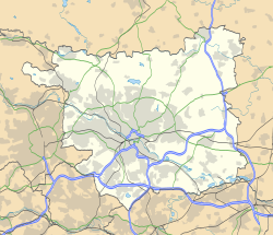
Leeds UK location map.svg
Red pog.svg
East Keswick
West Yorkshire UK location map.svg
Red pog.svg
East Keswick
Location within West Yorkshire
Population1,146 (2011)
OS grid reference SE360447
Civil parish
  • East Keswick
Metropolitan borough
Metropolitan county
Region
Country England
Sovereign state United Kingdom
Post town LEEDS
Postcode district LS17
Police West Yorkshire
Fire West Yorkshire
Ambulance Yorkshire
UK Parliament
List of places
UK
England
Yorkshire
53°53′50″N1°27′13″W / 53.89723°N 1.45364°W / 53.89723; -1.45364

East Keswick is a village and civil parish in the City of Leeds metropolitan borough, West Yorkshire, England. It lies four miles south west of Wetherby. The population of the civil parish as of the 2011 census was 1,146. [1]
Contents

Etymology

The name of East Keswick is first attested in the Domesday Book of 1086, in the forms Chesinc and Chesing. This name comes from the Old English words cēse ('cheese') and wīc ('dwelling, specialised farm'), and thus once meant 'farm specialising in cheese production'. The ch- spelling in the Domesday Book reflects the usual Old English pronunciation (also found in modern English cheese). Subsequent attestations, however, reflect the modern pronunciation [k-], the earliest being Keswic and Keswich. This reflects the influence of Old Norse pronunciation on the local language. [2] :42

The additional element East is first attested in twelfth-century forms such as Estkeswyck. It seems to have been added to distinguish the villages from other places called Keswick, such as the nearby Dunkeswick. [2] :42–43

Amenities

The Duke of Wellington public house The Duke of Wellington, East Keswick.jpg
The Duke of Wellington public house

The village has two churches (one Methodist, one Anglican), a butcher, village hall, and two pubs: the Old Star, [3] which is Grade II listed, [4] and the Duke of Wellington. [5] A third pub, the Travellers' Rest, [5] situated just outside the village, closed in the 2000s. [6] After lying derelict for several years, the Traveller's Rest is now a children's nursery. The village had a school, but this closed in 1990, [7] leaving the nearest school in Bardsey. The village's Post Office closed in the mid-2010s.

Conservation

The village is a conservation area surrounded by farmland. Its history has been chronicled in a Millennium Book and unusually it enjoys its own Wildlife Trust which manages large tracts of local land. [8]

Transport

The village is situated close to the A58 road between Leeds and Wetherby. The Transdev X99 route serves the village connecting it with Leeds, Wetherby and surrounding villages. There are no rail links close by.

See also

Notes

  1. "Civil Parish population 2011". Neighbourhood Statistics. Office for National Statistics. Retrieved 25 February 2016.
  2. 1 2 Harry Parkin, Your City's Place-Names: Leeds, English Place-Name Society City-Names Series, 3 (Nottingham: English Place-Name Society, 2017).
  3. EKVDG 2002, p. 20.
  4. Historic England. "The Old Star (1225911)". National Heritage List for England . Retrieved 26 August 2019.
  5. 1 2 EKVDG 2002, p. 22.
  6. "Dismay as more Leeds village pubs shut". Yorkshire Evening Post. 4 May 2010. Retrieved 12 December 2017.
  7. EKVDG 2002, p. 5.
  8. "East Keswick Wild Life Trust".

Bibliography


Related Research Articles

<span class="mw-page-title-main">Guiseley</span> Town in West Yorkshire, England

Guiseley is a town in metropolitan borough of the City of Leeds, West Yorkshire, England. Historically part of the West Riding of Yorkshire, it is situated south of Otley and Menston and is now a north-western suburb of Leeds.

<span class="mw-page-title-main">Wetherby</span> Town and civil parish in West Yorkshire, England

Wetherby is a market town and civil parish in the City of Leeds, West Yorkshire, England. It is close to West Yorkshire county's border with North Yorkshire, and lies approximately 12 miles from Leeds City Centre, 12 mi (19 km) from York and 8 mi (13 km) from Harrogate. The town stands on the River Wharfe, and for centuries has been a crossing place and staging post on the Great North Road midway between London and Edinburgh.

<span class="mw-page-title-main">Arthington</span> Village and civil parish in Leeds, West Yorkshire, England

Arthington is a linear village in Wharfedale, in the City of Leeds metropolitan borough in West Yorkshire, England. It is a civil parish which, according to the 2011 census, had a population of 532. It is in the Otley ward of the City of Leeds, and the Leeds North West parliamentary constituency.

<span class="mw-page-title-main">Garforth</span> Town in West Yorkshire, England

Garforth is a town in the metropolitan borough of the City of Leeds, West Yorkshire, England.

<span class="mw-page-title-main">Barwick-in-Elmet</span> Village in West Yorkshire, England

Barwick-in-Elmet is a village in West Yorkshire, 7 miles (11 km) east of Leeds city centre. It is one of only three places in the area to be explicitly associated with the ancient Romano-British kingdom of Elmet, the others being Scholes-in-Elmet and Sherburn-in-Elmet.

<span class="mw-page-title-main">Bramham, West Yorkshire</span> Village in West Yorkshire, England

Bramham is a village in the civil parish of Bramham cum Oglethorpe in the City of Leeds metropolitan borough, West Yorkshire, England.

<span class="mw-page-title-main">Kippax, West Yorkshire</span> Human settlement in England

Kippax is a town and civil parish in the City of Leeds, West Yorkshire, England. It is situated to the east of the city, near to Garforth and Great Preston.

<span class="mw-page-title-main">Allerton Bywater</span> Village and civil parish in West Yorkshire, England

Allerton Bywater is a semi-rural village and civil parish in the south-east of the City of Leeds metropolitan borough in West Yorkshire, England. The population of the civil parish at the 2011 census was 4,717. The village itself is 2 miles (3.2 km) north of Castleford, with neighbouring villages Kippax and Great Preston all providing local amenities. St Aidan's Nature reserve borders the village attracting many visitors with its beauty and charm. Additionally "The Lines Way" bridle path which runs from Garforth through to Allerton following the old train track provides a pleasant route for walkers, joggers and cyclists alike. The River Aire flows through the village to the south-west.

<span class="mw-page-title-main">Great Preston</span>

Great Preston is a small rural village in the City of Leeds metropolitan borough, West Yorkshire, England. It has incorporated the once neighbouring hamlet of Little Preston.

<span class="mw-page-title-main">Spofforth, North Yorkshire</span> Village in North Yorkshire, England

Spofforth is a village in the civil parish of Spofforth with Stockeld in the Harrogate district of North Yorkshire, England, about 3 miles (4.8 km) north west of Wetherby and 5 miles (8 km) south of Harrogate on the River Crimple, a tributary of the River Nidd.

<span class="mw-page-title-main">Thorner</span> Village and civil parish in West Yorkshire, England

Thorner is a rural village and civil parish in the City of Leeds in West Yorkshire, England, located between Seacroft and Wetherby. It had a population of 1,646 at the 2011 Census.

<span class="mw-page-title-main">Shadwell, West Yorkshire</span> Village and civil parish in West Yorkshire, England

Shadwell is a village and civil parish in north-east Leeds, West Yorkshire, England. The village is 6 miles (9.7 km) to the north east of Leeds city centre.

<span class="mw-page-title-main">Collingham, West Yorkshire</span> Village and civil parish in West Yorkshire, England

Collingham is a village and civil parish 2 miles (3 km) south-west of Wetherby in West Yorkshire, England. It is in the City of Leeds metropolitan borough. The population of the civil parish as of the 2011 census was 2,991.

<span class="mw-page-title-main">Bardsey, West Yorkshire</span> Village near Leeds, West Yorkshire, England

Bardsey, West Yorkshire, England is a small village in the City of Leeds metropolitan borough, 8 miles (13 km) north east of Leeds city centre. The village is in the LS17 Leeds postcode district. It is part of the civil parish of Bardsey cum Rigton. The village itself lies just off the A58 road between Leeds and Wetherby.

<span class="mw-page-title-main">Clifford, West Yorkshire</span> Village in West Yorkshire, England

Clifford is a village and civil parish in West Yorkshire, England. The population of the civil parish at the 2011 Census was 1,662. The village is 3 miles (4.8 km) south of Wetherby. Many of the older buildings are built of magnesian limestone.

<span class="mw-page-title-main">Eccup</span> Village in West Yorkshire, England

Eccup is a village in the parish of Alwoodley and north of the City of Leeds, West Yorkshire, England. It is just north of Alwoodley and east of Bramhope and Golden Acre Park. Eccup is at the north-west edge of Eccup Reservoir. On 1 April 1926 Eccup became a civil parish, being formed from part of Adel cum Eccup, on 1 April 1928 the parish was abolished and merged with Leeds.

<span class="mw-page-title-main">Kirk Smeaton</span> Village and civil parish in North Yorkshire, England

Kirk Smeaton is a village and civil parish in North Yorkshire, England. It is located at the southern end of the county, close to South Yorkshire and East Riding of Yorkshire. Historically, the village was part of the West Riding of Yorkshire until 1974.

<span class="mw-page-title-main">Sicklinghall</span> Village and civil parish in North Yorkshire, England

Sicklinghall is a village and civil parish in North Yorkshire, England that is situated between the town of Wetherby and the village of Kirkby Overblow.

<span class="mw-page-title-main">Bickerton, North Yorkshire</span> Village in North Yorkshire, England

Bickerton is a village on the B1224 road, in the civil parish of Bilton-in-Ainsty with Bickerton, in North Yorkshire, England. The nearest town is Wetherby. There is a plantation nearby called Bickerton Plantation.

<span class="mw-page-title-main">Dunkeswick</span> Hamlet in North Yorkshire, England

Dunkeswick is a hamlet in the civil parish of Kirkby Overblow, in North Yorkshire, England, just north of the River Wharfe, off the A61, around a kilometre north of Harewood and two kilometres south of Kirkby Overblow.