Hillam

Last updated

Hillam
20180722 114816 Cross Keys Hillam.jpg
Cross Keys Hillam
North Yorkshire UK location map (2023).svg
Red pog.svg
Hillam
Location within North Yorkshire
OS grid reference SE505285
Civil parish
  • Hillam
Unitary authority
Ceremonial county
Region
Country England
Sovereign state United Kingdom
Post town LEEDS
Postcode district LS25
Police North Yorkshire
Fire North Yorkshire
Ambulance Yorkshire
List of places
UK
England
Yorkshire
53°45′13″N1°13′50″W / 53.753611°N 1.230555°W / 53.753611; -1.230555

Hillam is a village and civil parish in the Selby District of North Yorkshire, England.

Contents

The village is closely linked to Monk Fryston [ further explanation needed ], although both villages maintain separate parish councils. According to the 2011 UK census the population of Hillam parish was 720 and the number of households was 277. [1]

The village was historically part of the West Riding of Yorkshire until 1974. [2]

History

The oldest record which names the village is dated 963 AD. [3] It records a grant of land in Sherburn-in-Elmet and nearby settlements by King Eadgar to Aelsac as a reward for goods and services. The land granted in Hillam is described as, "on Hillum tyesra oxena gang" meaning "in Hillam two oxgangs". [4] An oxgang was the related to the amount of land an ox could plough in a year and is roughly equated to 15 acres.

Hillam Square. Grid Ref SE508288 20180722 115045 HIllam Village Sign in Hillam Square.jpg
Hillam Square. Grid Ref SE508288

Heritage

The National Heritage List For England, compiled by English Heritage, lists ten Grade II listed buildings including one Grade II milestone in Hillam. [5]

Village features

The village is served by a public house, the Cross Keys, winner of Leeds City Council Business in Bloom Gold award in 2007 [6] and Yorkshire in Bloom Gold Award in 2007. [7]

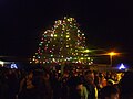
The Ring Tree is lit at Christmas and local children gather to enjoy a Christmas celebration each year. Due to disease the flowering horse-chestnut tree was felled in May 2016 and replaced with a whitebeam tree in November 2016. Hillam Historians [8] restored the village pump in Hillam Square during 2006. [9]

Hillam Square retains its red telephone box. In spring 2017 a defibrillator was installed.

Transport

Hillam is situated just over 6 miles west of the market town of Selby. It lies 2 miles east of the A1(M) motorway junction 42, and 4 miles north of the M62 junction 33, at Ferrybridge. The A63 road, Leeds to Selby, runs parallel to the northern boundary of the parish.

The Dearne Valley Line passes to the west of Hillam. There is a level crossing known as Hillam Gates. The spot is popular with railway enthusiasts. [10]

The pump in Hillam Square Hillam Pump.JPG
The pump in Hillam Square

Community

Hillam News, the village magazine, is distributed to each household every two months[ citation needed ]. Hillam News gives details of recent and forthcoming events, news, comment, current affairs and a precis of Hillam Parish Council meeting minutes.

Community activities are supported by the Monk Fryston and Hillam Community Association[ citation needed ]. Cultural, educational and social community activities are held at the Community Centre and Village Children's Playground.

Primary education needs are served by Monk Fryston Church of England Voluntary Controlled Primary School. The school has 198 pupils between 4 and 11 years of age[ citation needed ]. The original primary school building still remains as housing whilst the new primary school is located on what was the school field.

The parish church is St Wilfrid's Church, Monk Fryston (Church of England).

Sport

Hillam has a successful cricket team which competes in the Yorkshire Premier League Division 4 (1st XI) and 5 (2nd XI). Hillam and Monk Fryston Cricket Club's ground is noted for a tree at the boundary. Cricket has been played in Hillam over 100 years, and is very much a community activity, with all ages representing both teams[ citation needed ]. As of September 2022, there are two junior cricket teams, Under 11's and Under 13's. Next to the cricket field is Monk Fryston football club, which has teams for all ages.

Hillam Pond, known locally as the Brick Pond[ citation needed ], is located to the west of the village. It holds a variety of coarse fish including carp, perch, common roach, eel, bream and tench [ citation needed ].

Tour de Yorkshire

The 2016 Tour de Yorkshire passed through Hillam on Saturday 30 April 2016. The 135.5 km route between Otley and Doncaster was raced by both the men's and women's teams. The 2016 Women's Tour de Yorkshire raced through mid-morning and finally Stage 2 of the men's race swept through the village mid-afternoon.

Related Research Articles

<span class="mw-page-title-main">Wetherby</span> Town and civil parish in West Yorkshire, England

Wetherby is a market town and civil parish in the City of Leeds district, West Yorkshire, England, close to West Yorkshire county's border with North Yorkshire, and lies approximately 12 miles from Leeds City Centre, 12 mi (19 km) from York and 8 mi (13 km) from Harrogate. The town stands on the River Wharfe, and for centuries has been a crossing place and staging post on the Great North Road midway between London and Edinburgh.

<span class="mw-page-title-main">Rothwell, West Yorkshire</span> Market Town in West Yorkshire, England

Rothwell is a town in the south-east of the City of Leeds metropolitan borough in West Yorkshire, England. It is situated between Leeds and Wakefield.

<span class="mw-page-title-main">Selby District</span> Former local government district in England

Selby District was a local government district of North Yorkshire, England, from 1974 to 2023. Its council was based in the town of Selby. The district had a population of 83,449 at the 2011 Census. The southernmost district of North Yorkshire, it bordered the City of York unitary authority, the Borough of Harrogate in North Yorkshire, the City of Leeds and City of Wakefield districts in West Yorkshire, the City of Doncaster in South Yorkshire, and the ceremonial county of the East Riding of Yorkshire.

<span class="mw-page-title-main">Cookridge</span> Suburb of Leeds in West Yorkshire, England

Cookridge is a suburb of north-west Leeds, West Yorkshire, England, north of the Leeds Outer Ring Road. In 1715 Ralph Thoresby described it as a village four miles from Leeds and three from Otley, dating from 1540.

<span class="mw-page-title-main">Dunnington</span> Village and civil parish in North Yorkshire, England

Dunnington is a village and civil parish in the City of York and ceremonial county of North Yorkshire, England. The population of the civil parish was 3,230 at the 2011 Census. The village is approximately 4 miles (6 km) east from York city centre.

Osgoldcross Rural District was a rural district in the West Riding of Yorkshire, England. It was created in 1938, from 19 remaining parishes of the disbanded Pontefract Rural District after three-quarters of its population had been transferred to surrounding authorities - specifically to Castleford, Knottingley, and Pontefract.

<span class="mw-page-title-main">Garforth</span> Town in West Yorkshire, England

Garforth is a town in the metropolitan borough of the City of Leeds, West Yorkshire, England.

<span class="mw-page-title-main">Aberford</span> Village and civil parish near Leeds, West Yorkshire, England

Aberford is a village and civil parish on the eastern outskirts of the City of Leeds in West Yorkshire, England. It had a population of 1,059 at the 2001 census, increasing to 1,180 at the 2011 Census. It is situated 10 miles (15.5 km) east, north east of Leeds and west of the A1(M) motorway.

<span class="mw-page-title-main">Hutton Cranswick</span> Village and civil parish in the East Riding of Yorkshire, England

Hutton Cranswick is a village and civil parish in the East Riding of Yorkshire, England. It is situated approximately 3 miles (5 km) south from Driffield town centre, and on the A164 road.

<span class="mw-page-title-main">Bramham, West Yorkshire</span> Village in West Yorkshire, England

Bramham is a village in the civil parish of Bramham cum Oglethorpe in the City of Leeds metropolitan borough, West Yorkshire, England.

<span class="mw-page-title-main">Burton Salmon</span> Village and civil parish in North Yorkshire, England

Burton Salmon is a village and civil parish in the Selby district of North Yorkshire, England, close to the border with West Yorkshire, and approximately 3 miles (5 km) north from Knottingley, on the A162 road. According to the 2001 Census the parish had a population of 419, reducing slightly to 416 at the 2011 Census.

<span class="mw-page-title-main">Drighlington</span> Village and civil parish in West Yorkshire, England

Drighlington is a village and civil parish in the City of Leeds metropolitan district, West Yorkshire, England. Historically part of the West Riding of Yorkshire, the village lies 5 miles (9 km) south-west of Leeds and 4 miles (6 km) south-east of Bradford. The name of the village is often shortened to Drig. The population of the civil parish as of the 2011 census was 5,528.

<span class="mw-page-title-main">South Milford</span> Village and civil parish in North Yorkshire, England

South Milford is a village and civil parish in the county of North Yorkshire, England. The civil parish includes the hamlet of Lumby, located south-west of the main village.

<span class="mw-page-title-main">Swillington</span> Village and civil parish in West Yorkshire, England

Swillington is a village and civil parish near Leeds, West Yorkshire, England, in the City of Leeds metropolitan borough. It is situated 5 miles (8 km) east from Leeds city centre, north of the River Aire, and is surrounded by streams including Fleakingley Beck. In 2001, Swillington had a population of about 3,530, reducing to 3,381 at the 2011 Census.

<span class="mw-page-title-main">Shadwell, West Yorkshire</span> Village and civil parish in West Yorkshire, England

Shadwell is a village and civil parish in north-east Leeds, West Yorkshire, England. The village is 6 miles (9.7 km) to the north east of Leeds city centre.

<span class="mw-page-title-main">Micklefield</span> Village and civil parish in West Yorkshire, England

Micklefield is a village and civil parish in the City of Leeds in West Yorkshire, England. It neighbours Garforth, Aberford and Brotherton and is close to the A1(M) motorway. The population as of the 2011 Census was 1,893, increased from 1,852 in 2001.

<span class="mw-page-title-main">Thorpe Willoughby</span> Village and civil parish in North Yorkshire, England

Thorpe Willoughby is a village and civil parish in the Selby District of North Yorkshire, England. The village is situated just off the A1238 and is in close proximity to Selby.

<span class="mw-page-title-main">Monk Fryston</span> Village and civil parish in North Yorkshire, England

Monk Fryston is a small village and civil parish in the Selby district of North Yorkshire, England.

<span class="mw-page-title-main">Sicklinghall</span> Village and civil parish in North Yorkshire, England

Sicklinghall is a village and civil parish in North Yorkshire, England that is situated between the town of Wetherby and the village of Kirkby Overblow.

<span class="mw-page-title-main">Monk Fryston railway station</span> Disused railway station in North Yorkshire England

Monk Fryston railway station was a railway station serving the village of Monk Fryston in North Yorkshire, England. Previously, Milford Junction and Old Junction served as an interchange between the Leeds and Selby and the York and North Midland Lines, however when they closed in the early 1900s, Monk Fryston was opened to cover for this loss of interchange. Though the station had four tracks through it, it only ever had two platforms. The station closed to passengers in 1959, and then completely in 1964.

References

  1. "Neighbourhood Statistics – Area: Hillam CP". Office for National Statistics . Retrieved 16 February 2014.
  2. "History of Hillam, in Selby and West Riding | Map and description". www.visionofbritain.org.uk. Retrieved 25 November 2020.
  3. Farrer, William (1914). Early Yorkshire Charters Vol 1. Edinburgh: Ballantyne, Hanson and Co. Edinburgh. p. 19.
  4. Farrer, William (1914). Early Yorkshire Charters Vol 1. Edinburgh: Ballantyne, Hanson and Co. Edinburgh. p. 20.
  5. "The National Heritage List for England". English Heritage. 12 January 2013. Archived from the original on 1 May 2012. Retrieved 12 January 2013.
  6. "Well done business in bloom winners" (PDF) (Press release). Leeds City Council. October 2007. Archived from the original (PDF) on 10 June 2011. Retrieved 13 November 2007.
  7. "Results 2007" (PDF) (Press release). Yorkshire in Bloom. 4 September 2007. Retrieved 13 November 2007.[ permanent dead link ]
  8. Hillam Historians (2004). Hillam: a village remembered: selected findings of Hillam Historians. Hillam Historians. p. 119. ISBN   1-903833-69-8.
  9. "Water relief as pump restored". Selby Times. 28 July 2006. Archived from the original on 5 May 2013. Retrieved 13 November 2007.
  10. Hillam – Trainspots