Scott Hall, Leeds

Last updated

The start of the estate at the bottom of Scott Hall Road Scott Hall Estate South Boundary Marker.jpg
The start of the estate at the bottom of Scott Hall Road

Scott Hall is a suburb of north-east Leeds, West Yorkshire, England, adjacent to Chapeltown and Meanwood. The suburb falls within the Chapel Allerton and Moortown wards of Leeds City Council. The Scott Hall estate is made up largely of 1930s council housing on both sides of Scott Hall Road (and streets beyond) from Buslingthorpe Lane in the south to Potternewton Lane in the north.

Contents

Location and facilities

Scott Hall Road Scott Hall Road South East Feb 2017.jpg
Scott Hall Road
Bus to Shadwell on the Guided Bus Lane by Prince Philip Playing Fields Scott Hall Guided Bus 22 Feb 2017.jpg
Bus to Shadwell on the Guided Bus Lane by Prince Philip Playing Fields

The A61 road between Leeds and Harrogate is the main thoroughfare known as Scott Hall Road, served by First buses 7/7A/7S. [1] On this road, just north of Potternewton Lane in Miles Hill there are shops and the Scott Hall Leisure (sports) Centre which was refurbished at a cost of £500,000 in 2009. [2] [3] [4] Scott Hall Church, formerly Scott Hall Christian Fellowship and Hope Hall, is an Evangelical fellowship. [5] There is a guided bus route along Scott Hall Road, which has given rise to some controversy. [6] Scott Hall Oval is used by the Caribbean Cricket Club. [7] Part of the Leeds Half Marathon course goes through Scott Hall Road. [8]

History

The sports field at the junction between Scott Hall Road and Potternewton Lane used to be part of Scott Hall Farm. [9] The farmhouse itself, on Scott Hall Street, is a Grade II listed building but was on the Heritage at Risk list, being described as "vulnerable through neglect and decay" in 2009. [10] Bronte House (now flats) is a large building originally for single women, built in the 1930s at the junction of Buslingthorpe Lane and Scott Hall Drive. [11] The PHAB club, which assists disabled people to enjoy life alongside able-bodied friends, started at the Prince Philip Centre in Scott Hall Avenue in 1970. [12]

Two of the Yorkshire Ripper's victims lived just a few doors from each other in Scott Hall Avenue. They were his first victim, Wilma McCann, and his fifth, Jayne MacDonald. [13]

Related Research Articles

<span class="mw-page-title-main">Guiseley</span> Town in West Yorkshire, England

Guiseley is a town in metropolitan borough of the City of Leeds, West Yorkshire, England. Historically part of the West Riding of Yorkshire, it is situated south of Otley and Menston and is now a north-western suburb of Leeds.

<span class="mw-page-title-main">Moortown, Leeds</span> Suburb of Leeds in West Yorkshire, England

Moortown is a suburb of Leeds, West Yorkshire, England. It is a civil parish and sits in the Moortown ward of Leeds City Council in the north east of the city.

<span class="mw-page-title-main">Chapeltown, Leeds</span> Suburb of Leeds, West Yorkshire, England

Chapeltown is a suburb of north-east Leeds, in West Yorkshire, England. It is part of the Leeds City Council Ward of Chapel Allerton. It is approximately one mile north of Leeds city centre.

<span class="mw-page-title-main">Alwoodley</span> Suburb of Leeds and civil parish in West Yorkshire, England

Alwoodley is a suburb and civil parish of Leeds in West Yorkshire, England. It is 5 miles (8.0 km) north of central Leeds and is one of the most affluent areas of the county. Alwoodley lies in the LS17 postcode area which was reported to contain the most expensive housing area in Yorkshire and the Humber by The Times.

<span class="mw-page-title-main">Cookridge</span> Suburb of Leeds in West Yorkshire, England

Cookridge is a suburb of north-west Leeds, West Yorkshire, England, north of the Leeds Outer Ring Road. In 1715 Ralph Thoresby described it as a village four miles from Leeds and three from Otley, dating from 1540.

<span class="mw-page-title-main">Middleton, Leeds</span> Suburb of Leeds, West Yorkshire, England

Middleton is a largely residential suburb of Leeds in West Yorkshire, England and historically a village in the West Riding of Yorkshire. It is situated on a hill 4 miles (6 km) south of Leeds city centre and 165 miles (266 km) north north-west of London.

<span class="mw-page-title-main">Little London, Leeds</span> Area of Leeds, West Yorkshire, England

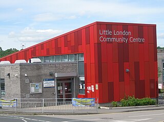
Little London is a residential area of Leeds in England, north of the city centre and Leeds Inner Ring Road. It is so called because in the 19th century it had fashionable housing and interesting architecture comparable to London. In the 1950s and '60s it became largely council housing and now consists of a mixture of high and low-rise flats and housing. The area falls within the Little London and Woodhouse ward of the City of Leeds Council. The area is divided into four estates; Lovell Park, Oatlands, Carlton and the Servias.

<span class="mw-page-title-main">Meanwood</span> Suburb of Leeds in West Yorkshire, England

Meanwood is a suburb and former village in north-west Leeds, West Yorkshire, England.

<span class="mw-page-title-main">Woodhouse, Leeds</span>

Woodhouse is a largely residential area just north of the city centre of Leeds and close to the University of Leeds. The area considered as Woodhouse is partly in the Little London and Woodhouse ward and partly in the Headingley & Hyde Park ward of City of Leeds metropolitan district.

Holt Park is a medium-sized low-rise 1970s housing estate in the northwest suburbs of Leeds, West Yorkshire, England. It is approximately 6 miles (10 km) from Leeds city centre situated between Tinshill, Cookridge and Adel, and is at the edge of the Leeds urban fringe, bordering the green belt which makes up two thirds of the metropolitan borough of the City of Leeds. The nearby Tinshill BT Tower dominates the skyline.

<span class="mw-page-title-main">Killingbeck</span> District of Leeds, West Yorkshire, England

Killingbeck is a district of east Leeds, West Yorkshire, England named after the Killingbeck family, historic local landowners, and is situated between Seacroft to the north, Cross Gates and Whitkirk to the east, Gipton to the west, Halton Moor to the south, Halton to the south-east and Osmondthorpe to the south-west.

<span class="mw-page-title-main">Potternewton</span> Suburb of Leeds, West Yorkshire, England

Potternewton also Potter Newton is a suburb and parish between Chapeltown and Chapel Allerton in north-east Leeds, West Yorkshire, England. It is in the Chapel Allerton ward of Leeds City Council.

<span class="mw-page-title-main">Swarcliffe</span> Area of the City of Leeds, West Yorkshire, England

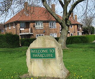
Swarcliffe, originally the Swarcliffe Estate, is a district of Leeds, West Yorkshire, England. It is 4.9 miles (8 km) east of Leeds city centre, and within the LS14 and LS15 Leeds postcode area. The district falls within the Cross Gates and Whinmoor ward of the Leeds Metropolitan Council.

<span class="mw-page-title-main">Moor Allerton</span>

Moor Allerton is an area of Leeds, West Yorkshire, England. The area is situated in North Leeds, near to King Lane and the Leeds Outer Ring Road.

<span class="mw-page-title-main">Architecture of Leeds</span> Buildings of Leeds, West Yorkshire, England

The architecture of Leeds, a city and metropolitan borough in West Yorkshire, England, encompasses a wide range of architectural styles and notable buildings. As with most northern industrial centres, much of Leeds' prominent architecture is of the Victorian era. However, the City of Leeds also contains buildings from as early as the Middle Ages such as Kirkstall Abbey, one of Britain's best preserved ruined Cistercian monasteries, as well as examples of 20th century industrial architecture, particularly in the districts of Hunslet and Holbeck.

<span class="mw-page-title-main">Thomas Nussey</span> British politician

Sir Thomas Willans Nussey, 1st BaronetDL JP was an English barrister and Liberal Party politician. He was the Member of Parliament (MP) for Pontefract from 1893 to 1910.

<span class="mw-page-title-main">Chapel Allerton</span> Suburb of Leeds in West Yorkshire, England

Chapel Allerton is an inner suburb of north-east Leeds, West Yorkshire, England, 2 miles (3.2 km) from the city centre.

<span class="mw-page-title-main">Adams & Kelly</span> 19th-century architectural firm in Leeds

Adams & Kelly was an architectural practice based at 18 Park Row, Leeds, Yorkshire, England. It was a partnership between Richard Life Adams (1840–1883) and John Kelly (1840–1904).

<span class="mw-page-title-main">Cockburn School</span> Secondary school in Beeston, West Yorkshire, England

Cockburn School is a mixed secondary school located in the Beeston area of Leeds, West Yorkshire, England.

References

  1. "Metro". Website front page. 2010. Retrieved 15 March 2010.
  2. "Leeds Online". Scott Hall Sports Centre. 2010. Retrieved 15 March 2010.
  3. "Leeds Live It Love It". Scott Hall Leisure Centre. 2009. Retrieved 15 March 2010.
  4. "Networks". Scott Hall Leisure Centre Refurb. 11 November 2009. Retrieved 15 March 2010.[ dead link ]
  5. Scott Hall Church, accessed 26 August 2020
  6. "Light Rail Transit Association - UK Development Group". Park & Ride, a doubtful response in Leeds. March 2001. Archived from the original on 18 July 2011. Retrieved 15 March 2010.
  7. "Caribbean Cricket Club". Club page. 2001. Retrieved 15 March 2010.
  8. "Leeds half marathon" (PDF). Route description. 10 May 2009. Archived from the original (PDF) on 29 June 2011. Retrieved 15 March 2010.
  9. "Scott Hall Farm (archive photo c. 1900)". Leodis. c. 1900. Retrieved 15 March 2010.
  10. "Leeds Civic Trust" (PDF). Heritage at risk. 2009. Retrieved 15 March 2010.
  11. "Archive photo of Bronte House". Leodis. 1930s. Retrieved 15 March 2010.
  12. "The Prince Philip PHAB club in Leeds". PHAB. 2009. Retrieved 15 March 2010.
  13. "Jayne MacDonald". Yorkshire Ripper history. Retrieved 15 March 2010.

Location grid

53°49′16″N1°32′28″W / 53.821°N 1.541°W / 53.821; -1.541