
Horsforth is a town and civil parish in the City of Leeds, West Yorkshire, England, five miles north-west of Leeds city centre. Historically a village within the West Riding of Yorkshire, it had a population of 18,895 at the 2011 Census. It became part of the City of Leeds metropolitan borough in 1974. In 1999, a civil parish was created for the area, and the parish council voted to rename itself a town council. The area is within the Horsforth ward of Leeds City Council, which also includes the southern part of Rawdon.
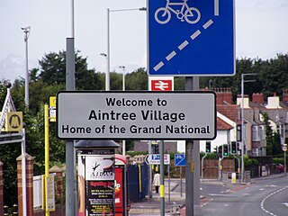
Aintree is a village and civil parish in the Metropolitan Borough of Sefton, Merseyside, England. Historically in Lancashire, it lies between Walton and Maghull on the A59 road, 6 miles northeast of Liverpool city centre. In 2011 the parish had a population of 6689.
Harehills is an inner-city area of east Leeds, West Yorkshire, England. It is about 1 mile (1.6 km) northeast of Leeds city centre. Harehills is between the A58 and the A64. It sits in the Gipton & Harehills ward of Leeds City Council and the Leeds East parliamentary constituency, between Burmantofts and Gipton, and adjacent to Chapeltown.

Chapeltown is a suburb of north-east Leeds, in West Yorkshire, England. It is part of the Leeds City Council Ward of Chapel Allerton. It is approximately one mile north of Leeds city centre.

Cookridge is a suburb of north-west Leeds, West Yorkshire, England, north of the Leeds Outer Ring Road. In 1715 Ralph Thoresby described it as a village four miles from Leeds and three from Otley, dating from 1540.

Woodhouse is a largely residential area just north of the city centre of Leeds and close to the University of Leeds. The area considered as Woodhouse is partly in the Little London and Woodhouse ward and partly in the Headingley & Hyde Park ward of City of Leeds metropolitan district.

Rawdon is a village and civil parish in the metropolitan borough of the City of Leeds, West Yorkshire, England. It sits on the River Aire and on the A65 south of Yeadon.

Trunch is a village and parish in Norfolk, England, situated three miles north of North Walsham and two miles from the coast at Mundesley. At the Census 2011 the village had a population of 909. The parish covers an area of 5.5 square kilometres (2.1 sq mi).

Bardsey cum Rigton is a civil parish in the City of Leeds metropolitan borough in West Yorkshire, England. According to the 2001 census it had a population of 2,385, increasing to 2,525 at the 2011 Census. The parish includes the villages of Bardsey, East Rigton and Thornhurst.

Drighlington is a village and civil parish in the City of Leeds metropolitan district, West Yorkshire, England. Historically part of the West Riding of Yorkshire, the village lies 5 miles (9 km) south-west of Leeds and 4 miles (6 km) south-east of Bradford. The name of the village is often shortened to Drig. The population of the civil parish as of the 2011 census was 5,528.

Gildersome is a village and civil parish in the City of Leeds metropolitan borough 5 miles (7 km) south-west of Leeds city centre in West Yorkshire, England. Glidersome forms part of the Heavy Woollen District.

Calverley is a village in the City of Leeds metropolitan borough in West Yorkshire, England, on the A657 road, about ten miles (16 km) from Leeds city centre and four miles (7 km) from Bradford, and lying north of the town of Pudsey. The population of Calverley in 2011 was 4,328. It is part of the City's Calverley and Farsley ward, with a population of 22,594 at the 2011 census.

West Ardsley is a settlement on the south-west edge of the City of Leeds metropolitan borough, in the county of West Yorkshire, England. Historically part of the West Riding of Yorkshire, it roughly approximates to an amalgamation of Tingley, Woodkirk, Hill Top, Upper Green, Common Side, Beggarington Hill and a number of other hamlets. The parish church is situated at Woodkirk and Methodist church on Haigh Moor Road. Being in the middle of several towns, West Ardsley has become a dormitory settlement.

Rodley is a suburb in the City of Leeds metropolitan borough, West Yorkshire, England. The village is situated within the Calverley and Farsley ward of Leeds Metropolitan Council, just inside the Leeds Outer Ring Road, 5 miles (8.0 km) north-west from Leeds city centre and 4 miles (6.4 km) north-east from Bradford. The hamlet of Bagley borders Rodley.

Cruckmeole is a small hamlet in Shropshire, England. It is located on the A488, where a lane which connects Cruckmeole to the B4386 crossroads at Cruckton forms a three way junction near to Hanwood. It is within the civil parish of Pontesbury.
Puddington is a village and civil parish on the Wirral Peninsula, in the unitary authority of Cheshire West and Chester and the ceremonial county of Cheshire, England. It is located to the south east of the town of Neston and close to the border with Wales.

Potternewton also Potter Newton is a suburb and parish between Chapeltown and Chapel Allerton in north-east Leeds, West Yorkshire, England. It is in the Chapel Allerton ward of Leeds City Council.

Chapel Allerton is an inner suburb of north-east Leeds, West Yorkshire, England, 2 miles (3.2 km) from the city centre.
Calverley and Farsley is a ward in the metropolitan borough of the City of Leeds, West Yorkshire, England. It contains 49 listed buildings that are recorded in the National Heritage List for England. Of these, one is listed at Grade I, the highest of the three grades, two are at Grade II*, the middle grade, and the others are at Grade II, the lowest grade. The ward contains the town of Farsley with the district of Stanningley to the south, the villages of Calverley and Rodley in the north of the ward, and the surrounding area. Most of the listed buildings are houses, cottages and associated structures, farmhouses and farm buildings. The Leeds and Liverpool Canal passes through the ward and the listed buildings associated with it are two swing bridges and warehouses. The other listed buildings include churches, chapels and items in churchyards, public houses, a bridge over the River Aire, a mill building, schools, and two war memorials.

