
Boston Spa is a village and civil parish in the Leeds Metropolitan District in West Yorkshire, England. Situated 3 miles (5 km) south of Wetherby, Boston Spa is on the south bank of the River Wharfe across from Thorp Arch. According to the 2001 census, the parish had a population of 4,006 rising to 4,079 in the 2011 census.

Bramham is a village in the civil parish of Bramham cum Oglethorpe in the City of Leeds metropolitan borough, West Yorkshire, England.

Byram cum Sutton is a civil parish in the Selby District of North Yorkshire, England, containing the village of Byram and the hamlet of Sutton. The River Aire runs to the south of the parish, and the town of Knottingley is the other side of the river in West Yorkshire. The A1(M) passes to the west of the parish. According to the 2001 census, it had a population of 1,406, increasing to 1,434 at the 2011 Census.

Wetherby was a rural district in the West Riding of Yorkshire from 1894 to 1974. It was named after the town of Wetherby.

Tushingham cum Grindley is a former civil parish, now in the parish of Tushingham-cum-Grindley, Macefen and Bradley, in the unitary authority of Cheshire West and Chester and the ceremonial county of Cheshire, England. The parish contained the village of Tushingham and the hamlet of Bell o' th' Hill. According to the 2001 UK census, the total population of the civil parish was 166, rising to 187 at the 2011 Census.

Kelsale cum Carlton is a civil parish in the English county of Suffolk. Situated to the north of Saxmundham, Kelsale cum Carlton is one of the largest parishes in Suffolk by area and includes, in addition to Kelsale and Carlton, villages and hamlets such as Dorley's Corner, Curlew Green, East Green and North Green within its boundaries. The population of the civil parish at the 2011 Census was 990. It forms an exclave of the Hoxne Hundred. The parish was formed in 1885.

Barkston Ash was a wapentake of the West Riding of Yorkshire, named after the meeting-place at the village of Barkston. It included the parishes of Birkin, Bramham cum Oglethorpe, Brayton, Drax, Kirk Fenton, Ledsham, Monk Fryston, Saxton with Scarthingwell and Sherburn-in-Elmet and parts of Brotherton, Kirkby Wharfe, Ryther, Snaith and Tadcaster.

Clifford is a village and civil parish in West Yorkshire, England. The population of the civil parish at the 2011 Census was 1,662. The village is 3 miles (4.8 km) south of Wetherby. Many of the older buildings are built of magnesian limestone.

Dodcott cum Wilkesley is a civil parish in the unitary authority of Cheshire East and the ceremonial county of Cheshire, England. The hamlet of Wilkesley lies 2+1⁄2 miles to the west of Audlem and 7 miles to the south west of Nantwich. The parish also includes the village of Burleydam, the largest settlement, as well as the small settlements of Butterley Heyes, Cheshire Fields, Combermere, Lightwood Green and Royal's Green. It also formerly contained the settlements of Pinsley Green and Smeaton Wood, now located in Wrenbury cum Frith civil parish. Nearby villages include Adderley and Calverhall in Shropshire and Audlem, Newhall and Wrenbury within Cheshire.

Checkley cum Wrinehill is a former civil parish, now in the parish of Doddington and District, in the unitary authority area of Cheshire East and the ceremonial county of Cheshire, England, which lies adjacent to the boundaries with Shropshire and Staffordshire. The hamlet of Checkley lies to the south east of Crewe and to the west of Newcastle-under-Lyme. The parish is largely rural but also includes the small settlements of Bunkers Hill and Randilow. Wrinehill was formerly included in the parish, becoming part of Staffordshire in 1965. Nearby villages include Blakenhall, Bridgemere, Madeley and Woore. In 2001 the parish had a population of 129.
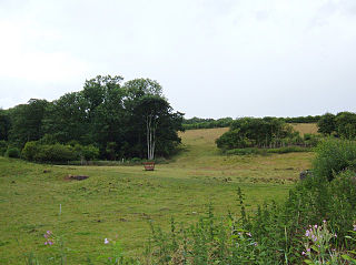
Wothersome is a civil parish in the City of Leeds metropolitan borough, West Yorkshire, England. It is south of Wetherby, north east of Leeds and west of Bramham. It has a population of 40. From the 2011 Census the village is shown as being in the Harewood ward of Leeds Metropolitan Council.

Isley cum Langley is a civil parish in the North West Leicestershire district of Leicestershire, England, lying immediately south-west of East Midlands Airport. According to the 2001 census it had a population of 64. At the 2011 census the population of the civil parish remained less than 100 and was included in the civil parish of Breedon on the Hill.

Bradley is a former civil parish, now in the parish of Tushingham-cum-Grindley, Macefen and Bradley, in the Cheshire West and Chester district, and the ceremonial county of Cheshire in England. In 2001 it had a population of 61. The main settlement in the parish was the village of Bradley Green.

Marlston-cum-Lache is a former civil parish, now in the parishes of Dodleston and Eaton and Eccleston, in the Cheshire West and Chester district and ceremonial county of Cheshire in England. In 2001 it had a population of 112, increasing to 166 at the 2011 Census. Marlston cum Lache is served by the A483 road which is the main road to Chester. Marlston-cum-Leach was formerly a township in the parish of St Mary-on-the-Hill, in 1866 Marlston cum Lache became a separate civil parish, on 1 April 2015 the parish was abolished and merged with Dodleston, part also went to form "Eaton and Eccleston".

Newton Kyme is a village in the civil parish of Newton Kyme cum Toulston near the River Wharfe, in the Selby district, in the English county of North Yorkshire. The population of the civil parish at the 2011 Census was 275. It is near the town of Tadcaster. For transport there is the A659 road nearby. Newton Kyme has a church and a castle called Kyme Castle.
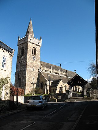
All Saints' Church in Bramham, West Yorkshire, England is an active Anglican parish church and Grade II* listed building in the Deanery of New Ainsty, the Archdeaconry of York and the Diocese of York. It is part of The Bramham Benefice, a group of four churches serving villages to the east of Wetherby in the LS23 postcode area. The current Priest in Charge is Reverend Nicholas J. Morgan, MA.
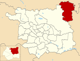
Wetherby is an electoral ward of Leeds City Council in north east Leeds, West Yorkshire, covering the town of Wetherby and villages including Boston Spa, Bramham and Thorp Arch.
Bramham cum Oglethorpe is a civil parish in the metropolitan borough of the City of Leeds, West Yorkshire, England. It contains 40 listed buildings that are recorded in the National Heritage List for England. Of these, nine are listed at Grade I, the highest of the three grades, two are at Grade II*, the middle grade, and the others are at Grade II, the lowest grade. The parish contains the village of Bramham and the surrounding area. In the parish is Bramham Park, a country house, which is listed together with a number of structures in its grounds. The other listed buildings include houses, cottages and associated structures, farmhouses and farm buildings, a church, the remains of a medieval cross, a disused windmill, a former aircraft hangar, and a war memorial.


