Appin

Last updated

Appin
Appin Village.jpg
Appin village, at the seaward end of the Strath of Appin
Argyll and Bute UK location map.svg
Red pog.svg
Appin
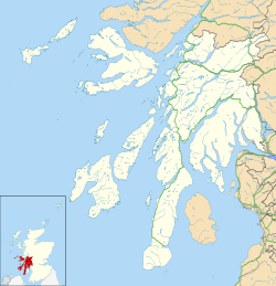
Location within Argyll and Bute
  Edinburgh 133 miles
  London 510 miles
Council area
Country Scotland
Sovereign state United Kingdom
Post town Appin
Postcode district PA38
Police Scotland
Fire Scottish
Ambulance Scottish
UK Parliament
Scottish Parliament
List of places
UK
Scotland
56°33′44″N5°21′32″W / 56.562222°N 5.358889°W / 56.562222; -5.358889 Coordinates: 56°33′44″N5°21′32″W / 56.562222°N 5.358889°W / 56.562222; -5.358889

Appin (Scottish Gaelic : An Apainn) is a coastal district of the Scottish West Highlands bounded to the west by Loch Linnhe, to the south by Loch Creran, to the east by the districts of Benderloch and Lorne, and to the north by Loch Leven. It lies northeast to southwest, and measures 23 by 11 kilometres (14 by 7 miles). [1] The name, meaning "abbey land", in reference to Ligmore Abbey, is derived from the Middle Irish apdaine. [2]

Contents

The district is mainly in Argyll and Bute, with a coastal strip to the north, along Loch Leven, within the Highland council area.

The scenery of the district is a combination of seascapes with rugged and mountainous country inland. Appin forms part of the Lynn of Lorn National Scenic Area, one of 40 in Scotland. [3] The principal hills are double peaks of Beinn a' Bheithir1,025 and 1,001 m (3,362 and 3,284 ft), respectively – and Creag Ghorm – 723 m (2,372 ft) – in the north, and Fraochaidh 879 m (2,883 ft), Meall Bàn 655 m (2,148 ft) and Beinn Mhic na Cèisich 638 m (2,093 ft) near the western flank of Glen Creran. The chief rivers are the Coe and Laroch, flowing into Loch Leven, the Duror and Salachan flowing into Loch Linnhe, and the Iola and Creran flowing into Loch Creran. [1]

The ferry to Lismore at Port Appin Port Appin 0350.jpg
The ferry to Lismore at Port Appin

The leading industries are forestry and tourism, with lead mining and slate quarrying being of former importance, but the Glensanda superquarry, in Morvern on the opposite bank of Loch Linnhe also provides local employment. Ballachulish, Duror, Portnacroish, Appin Village and Port Appin are the principal villages.

Appin was the country of a branch of the Stewarts. [1]

The A828 road runs along the coast of Appin. A passenger-only ferry to the island of Lismore runs from Port Appin. The district formerly had a railway, but the Caledonian Railway company's branch line from Connel to Ballachulish was closed in 1966.

Appin is where the Appin Murder took place in 1752.
Notable residents

Related Research Articles

<span class="mw-page-title-main">Highland (council area)</span> Council area of Scotland

Highland is a council area in the Scottish Highlands and is the largest local government area in the United Kingdom. It was the 7th most populous council area in Scotland at the 2011 census. It shares borders with the council areas of Aberdeenshire, Argyll and Bute, Moray and Perth and Kinross. Their councils, and those of Angus and Stirling, also have areas of the Scottish Highlands within their administrative boundaries.

<span class="mw-page-title-main">Argyll and Bute</span> Council area of Scotland

Argyll and Bute is one of 32 unitary authority council areas in Scotland and a lieutenancy area. The current Lord-Lieutenant for Argyll and Bute is Jane Margaret MacLeod. The administrative centre for the council area is in Lochgilphead at Kilmory Castle, a 19th-century Gothic Revival building and estate. The current Council leader is Councillor Robin Currie, a councillor for Kintyre and the Islands.

<span class="mw-page-title-main">A82 road</span> Major road in Scotland from Glasgow to Inverness

The A82 is a major road in Scotland that runs from Glasgow to Inverness via Fort William. It is one of the principal north-south routes in Scotland and is mostly a trunk road managed by Transport Scotland, who view it as an important link from the Central Belt to the Scottish Highlands and beyond. The road passes close to numerous landmarks, including; Loch Lomond, Rannoch Moor, Glen Coe, the Ballachulish Bridge, Ben Nevis, the Commando Memorial, Loch Ness, and Urquhart Castle.

<span class="mw-page-title-main">Argyll</span> Historic county in Scotland

Argyll, sometimes called Argyllshire, is a historic county and registration county of western Scotland.

<span class="mw-page-title-main">Loch Linnhe</span>

Loch Linnhe is a sea loch on the west coast of Scotland. The part upstream of Corran is known in Gaelic as An Linne Dhubh, and downstream as An Linne Sheileach. The name Linnhe is derived from the Gaelic word linne, meaning "pool".

<span class="mw-page-title-main">Loch Leven (Highlands)</span>

Loch Leven is a sea loch located on the west coast of Scotland. It is spelled Loch Lyon in Timothy Pont's map of the area and is pronounced Li' un. The local Gaelic pronunciation is Lee' oon

<span class="mw-page-title-main">Ballachulish</span> Human settlement in Scotland

The village of Ballachulish in Lochaber, Highland, Scotland, is centred on former slate quarries. The name Ballachulish was more correctly applied to the area now called North Ballachulish, to the north of Loch Leven, but was usurped for the quarry villages at East Laroch and West Laroch, either side of the River Laroch, which were actually within Glencoe and South Ballachulish respectively.

Glen Coe is a glen of volcanic origins, in the Highlands of Scotland. It lies in the north of the county of Argyll, close to the border with the historic province of Lochaber, within the modern council area of Highland. The glen is noted for its scenic beauty.

<span class="mw-page-title-main">Beinn a' Bheithir</span> Mountain in the Scottish Highlands

Beinn a' Bheithir is a mountain south of Ballachulish and Loch Leven in the Scottish Highlands. It has two Munro summits: Sgorr Dhearg at 1,024 m (3,360 ft) and Sgorr Dhonuill at 1,001 m (3,284 ft).

<span class="mw-page-title-main">Ardgour</span>

Ardgour is an area of the Scottish Highlands on the western shore of Loch Linnhe. It lies north of the district of Morvern and east of the district of Sunart. Administratively it is now part of the ward management area of Lochaber, in Highland council area. It forms part of the traditional shire and current registration county of Argyll.

Glenachulish is a hamlet and glen which lie close to the village of Ballachulish in the Scottish Highlands.

<span class="mw-page-title-main">Clan Stewart of Appin</span> Scottish clan branch

Clan Stewart of Appin is the West Highland branch of the Clan Stewart and have been a distinct clan since their establishment in the 15th century. Their Chiefs are descended from Sir James Stewart of Perston, who was himself the grandson of Alexander Stewart, the fourth High Steward of Scotland. His cousin Walter Stewart, the 6th High Steward, married Marjorie Bruce, the daughter of King Robert the Bruce, and their son Robert II was the first Stewart Monarch. The Stewarts of Appin are cousins to the Royal Stewart Monarchy.

Eriska is a flat tidal island at the entrance to Loch Creran on the west coast of Scotland. Privately owned by the Buchanan-Smiths from 1973 until August 2016, Eriska is now owned by Creation Gem, a family-owned business from Hong Kong. The island is run as a hotel with wooded grounds. The island is evidently populated although no record for the total was provided by the census in 2001 or 2011.

National Cycle Route 78 runs from Campbeltown to Inverness. It was officially launched as the Caledonia Way in 2016 as part of the wider redevelopment of Scotland's cycle network. It runs from the Kintyre peninsula to the Great Glen and the route varies from on road to traffic-free forest trails and canal paths.

<span class="mw-page-title-main">A828 road</span> Road on the Scottish West Coast

The A828 road is a primary route along the western coast of Scotland

<span class="mw-page-title-main">Loch Creran</span> Sea loch in Argyll and Bute, Scotland

Loch Creran is a sea loch in Argyll, on the west coast of Scotland. It is about 10 kilometres (6.2 mi) long from its head at Invercreran to its mouth on the Lynn of Lorne, part of Loch Linnhe. The loch separates the areas of Benderloch to the south and Appin to the north. The island of Eriska lies at the mouth of the loch. The loch is bridged at its narrowest point at Creagan, by the A828 road. The village of Barcaldine lies on the south shore of the loch.

<span class="mw-page-title-main">Corran Ferry</span>

The Corran Ferry crosses Loch Linnhe at the Corran Narrows, south of Fort William, Scotland.

<span class="mw-page-title-main">Cuil Bay</span> Body of water

Cuil Bay, meaning recess, corner, niche or nook, is a 237° facing, large sand and shingle coastal embayment with a semi-circular outline, on a chord of 2 km, situated on the south‐west part of the Ardsheal peninsula, on the southern coast of the sea loch of Loch Linnhe, in the parish of Lismore and Appin, within the council area of Lochaber in Scotland. It was formerly part of Argyll and Bute before boundary changes occurred. The bay is situated adjacent to the village of Duror. The bay is reached by a small road that leads from the Duror Primary School, leaving the main A828 road, following the line of the River Duror, as it races to meet the sea, before opening out into a vista of a long shore of meadows and sea-grasses as the land meets the bay proper.

<span class="mw-page-title-main">Duror</span> Human settlement in Scotland

Duror,, occasionally Duror of Appin is a small, remote coastal village that sits at the base of Glen Duror, in district of Appin, in the Scottish West Highlands, within the council area of Argyll and Bute in Scotland. Duror is known for the first building of the Telford Parliamentary churches by the Scottish civil engineer, architect and stonemason, Thomas Telford, from 1826, the first in a series of 32, built in Scotland. William Thomson was the architect. Duror is the location of the famous Appin Murder. Although no direct evidence for this connection exists, the murder event and the kidnap of James Annesley, supposedly provided the inspiration for Robert Louis Stevenson writing the novel Kidnapped.

References

  1. 1 2 3 Wikisource-logo.svg One or more of the preceding sentences incorporates text from a publication now in the public domain : Chisholm, Hugh, ed. (1911). "Appin". Encyclopædia Britannica . Vol. 2 (11th ed.). Cambridge University Press. p. 222.
  2. Field, John (1980). Place-names of Great Britain and Ireland. Newton Abbot, Devon: David & Charles. p. 24. ISBN   0389201545. OCLC   6964610.
  3. "National Scenic Areas" Archived 2017-03-11 at the Wayback Machine . SNH. Retrieved 30 Mar 2011.
  4. "Female Orphan School and Historical Precinct, Parramatta Campus". Whitlam Institute . 2009. Archived from the original on 11 April 2010. Retrieved 28 April 2010.