
Ayrshire is a historic county and registration county, in south-west Scotland, located on the shores of the Firth of Clyde. The lieutenancy area of Ayrshire and Arran covers the entirety of the historic county as well as the island of Arran, formerly part of the historic county of Buteshire. Its principal towns include Ayr, Kilmarnock and Irvine and it borders the counties of Renfrewshire and Lanarkshire to the north-east, Dumfriesshire to the south-east, and Kirkcudbrightshire and Wigtownshire to the south. Like many other counties of Scotland, it currently has no administrative function, instead being sub-divided into the council areas of East Ayrshire, North Ayrshire and South Ayrshire. It has a population of approximately 366,800.
East Ayrshire is one of 32 unitary council areas of Scotland. It shares borders with Dumfries and Galloway, East Renfrewshire, North Ayrshire, South Ayrshire and South Lanarkshire. The headquarters of the council are located on London Road, Kilmarnock. With South Ayrshire and the mainland areas of North Ayrshire, it formed the former county of Ayrshire.

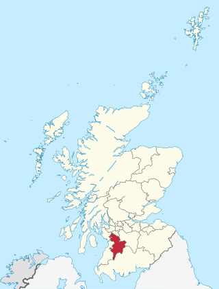
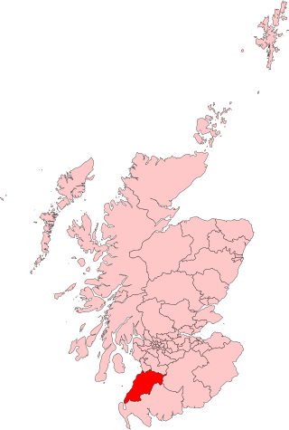
South Ayrshire is one of thirty-two council areas of Scotland, covering the southern part of Ayrshire. It borders onto Dumfries and Galloway, East Ayrshire and North Ayrshire. South Ayrshire had an estimated population in 2021 of 112,450, making it the 19th–largest subdivision in Scotland by population. With an area of 472 sq mi, South Ayrshire ranks as the 15th largest subdivision in Scotland.

Ayr is a town situated on the southwest coast of Scotland. A former royal burgh, today it is the administrative centre of the South Ayrshire Council, and the historic county town of Ayrshire. With a population of 46,982, Ayr is the 15th largest settlement in Scotland and second largest town in Ayrshire by population. The town is contiguous with the smaller town of Prestwick to the north. Ayr submitted unsuccessful bids for city status in 2000 and 2002, and as part of the wider South Ayrshire area in 2022.

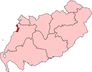
Cunninghame is a former comital district of Scotland and also a district of the Strathclyde Region from 1975 to 1996.
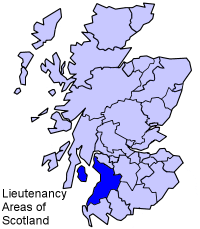
Ayrshire and Arran is a lieutenancy area of Scotland. It consists of the council areas of East Ayrshire, North Ayrshire and South Ayrshire. The area of Ayrshire and Arran is also a brand for tourist attractions.

Cumnock and Doon Valley was one of nineteen local government districts in the Strathclyde region of Scotland from 1975 to 1996.

Kyle and Carrick was one of nineteen local government districts in the Strathclyde region of Scotland from 1975 to 1996.

Prestwick is a town in South Ayrshire on the west coast of Ayrshire in Scotland about 30 miles southwest of Glasgow. It adjoins the larger town of Ayr to the south on the Firth of Clyde coast, the centre of which is about two miles south, and the small village of Monkton to the north. It had a population of 14,901 at the 2011 census.
Ayr, Carrick and Cumnock is a county constituency represented in the House of Commons of the Parliament of the United Kingdom. It was created for the 2005 general election from parts of the old Ayr and Carrick, Cumnock and Doon Valley constituencies. It has been represented since 2024 by Elaine Stewart of Scottish Labour.

Central Ayrshire is a constituency of the British House of Commons, located in the south-west of Scotland within the North Ayrshire and South Ayrshire council areas. It elects one Member of Parliament (MP) at least once every five years using the first-past-the-post system of voting.
Ayr was a county constituency of the House of Commons of the Parliament of the United Kingdom from 1950 to 2005. It elected one Member of Parliament (MP) by the first-past-the-post system of election.
South Ayrshire was a county constituency of the House of Commons of the Parliament of the United Kingdom from 1868 until 1983, when it was abolished. It returned one Member of Parliament (MP), elected by the first past the post voting system.
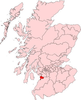
Ayr is a burgh constituency of the Scottish Parliament (Holyrood) covering the town of Ayr in the council area of South Ayrshire. It elects one Member of the Scottish Parliament (MSP) via the plurality electoral system. It is also one of nine constituencies in the South Scotland electoral region which elects seven additional members to the Scottish Parliament via a proportional electoral system known as the Additional Members System which allows for greater accuracy in representation for the region as a whole.

Carrick, Cumnock and Doon Valley is a county constituency of the Scottish Parliament at Holyrood, covering parts of the council areas of South Ayrshire and East Ayrshire. It elects one Member of the Scottish Parliament (MSP) by the plurality method of election. Also, it is one of nine constituencies in the South Scotland electoral region, which elects seven additional members, in addition to the nine constituency MSPs, to produce a form of proportional representation for the region as a whole.

Carrick, Cumnock and Doon Valley was a county constituency represented in the House of Commons of the Parliament of the United Kingdom from 1983 until 2005. Half of the constituency was incorporated into the new Ayr, Carrick and Cumnock constituency, with the remainder incorporated into the new Central Ayrshire constituency and the expanded Kilmarnock and Loudoun constituency.
Doonfoot is a suburb in the south-west of Ayr, South Ayrshire.

The 2012 South Ayrshire Council election took place on 3 May 2012 on the same day as the 31 other Scottish local government elections. As with other Scottish council elections, it was held using single transferable vote (STV) – a form of proportional representation – in which multiple candidates are elected in each ward and voters rank candidates in order of preference.
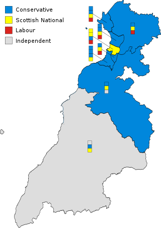
The 2017 South Ayrshire Council election took place on 4 May 2017 on the same day as the 31 other Scottish local government elections. As with other Scottish council elections, it was held using single transferable vote (STV) – a form of proportional representation – in which multiple candidates are elected in each ward and voters rank candidates in order of preference.
Patna and Dalrymple was one of 32 electoral wards of East Ayrshire Council. Originally created in 1974, the ward was initially within Cumnock and Doon Valley District Council before the local government reforms in the 1990s. The ward elected one councillor using the first-past-the-post voting electoral system.


