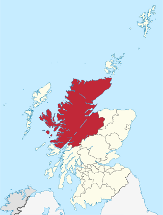
Highland is a council area in the Scottish Highlands and is the largest local government area in the United Kingdom. It was the 7th most populous council area in Scotland at the 2011 census. It shares borders with the council areas of Aberdeenshire, Argyll and Bute, Moray and Perth and Kinross. Their councils, and those of Angus and Stirling, also have areas of the Scottish Highlands within their administrative boundaries.

Argyll and Bute is one of 32 unitary council areas in Scotland and a lieutenancy area. The current lord-lieutenant for Argyll and Bute is Jane Margaret MacLeod. The administrative centre for the council area is in Lochgilphead at Kilmory Castle, a 19th-century Gothic Revival building and estate. The current council leader is Councillor Jim Lynch.

Glencoe or Glencoe Village is the main settlement in Glen Coe in the Lochaber area of the Scottish Highlands. It lies at the north-west end of the glen, on the southern bank of the River Coe where it enters Loch Leven.
Kinlochleven is a coastal village located in Lochaber, in the Scottish Highlands and lies at the eastern end of Loch Leven. To the north lie the Mamores ridge; to the south lie the mountains flanking Glen Coe.
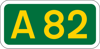
The A82 is a major road in Scotland that runs from Glasgow to Inverness via Fort William. It is one of the principal north-south routes in Scotland and is mostly a trunk road managed by Transport Scotland, who view it as an important link from the Central Belt to the Scottish Highlands and beyond. The road passes close to numerous landmarks, including Loch Lomond, Rannoch Moor, Glen Coe, the Ballachulish Bridge, Ben Nevis, the Commando Memorial, Loch Ness, and Urquhart Castle. Along with the A9 and the A90 it is one of the three major north–south trunk roads connecting the Central Belt to the North.
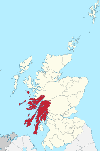
Argyll, sometimes called Argyllshire, is a historic county and registration county of western Scotland.

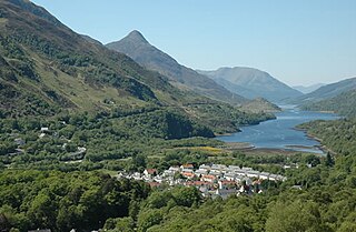
The village of Ballachulish in Lochaber, Highland, Scotland, is centred on former slate quarries. The name Ballachulish was more correctly applied to the area now called North Ballachulish, to the north of Loch Leven, but was usurped for the quarry villages at East Laroch and West Laroch, either side of the River Laroch, which were actually within Glencoe and South Ballachulish respectively.
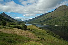
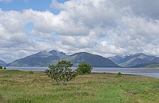
Glen Coe is a glen of volcanic origins, in the Highlands of Scotland. It lies in the north of the county of Argyll, close to the border with the historic province of Lochaber, within the modern council area of Highland. Glen Coe is regarded as the home of Scottish mountaineering and is popular with hillwalkers and climbers.

Beinn a' Bheithir is a mountain south of Ballachulish and Loch Leven in the Scottish Highlands. It has two Munro summits: Sgorr Dhearg at 1,024 m (3,360 ft) and Sgorr Dhonuill at 1,001 m (3,284 ft).

Ardgour is an area of the Scottish Highlands on the western shore of Loch Linnhe. It lies north of the district of Morvern and east of the district of Sunart. Administratively it is now part of the ward management area of Lochaber, in Highland council area. It forms part of the traditional shire and current registration county of Argyll.
Ross-shire is a historic county in the Scottish Highlands. The county borders Sutherland to the north and Inverness-shire to the south, as well as having a complex border with Cromartyshire – a county consisting of numerous enclaves or exclaves scattered throughout Ross-shire's territory. Ross-shire includes most of Ross along with Lewis in the Outer Hebrides. Dingwall is the traditional county town. The area of Ross-shire is based on that of the historic province of Ross, but with the exclusion of the many enclaves that form Cromartyshire.
Glenachulish is a hamlet and glen which lie close to the village of Ballachulish in the Scottish Highlands.
Chì mi na mòrbheanna is a Scottish Gaelic song that was written in 1856 by Highlander John Cameron. The song's tune was performed on the bagpipes during the state funerals of John F. Kennedy in 1963, Queen Elizabeth The Queen Mother in 2002, Queen Elizabeth II in 2022, Former Ontario Lieutenant Governor David Onley in 2023 and Former Canadian Prime Minister Brian Mulroney in 2024.

Ballachulish was a railway station at Ballachulish on the southern shore of Loch Leven at East Laroch in Highland. It was the terminus of the Ballachulish branch line that linked to the main line of the Callander and Oban Railway at Connel Ferry.

Eilean Munde is a small uninhabited island in Loch Leven, close to Ballachulish.
National Cycle Route 78 runs from Campbeltown to Inverness. It was officially launched as the Caledonia Way in 2016 as part of the wider redevelopment of Scotland's cycle network. It runs from the Kintyre peninsula to the Great Glen and the route varies from on road to traffic-free forest trails and canal paths.

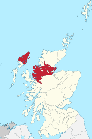
Inverness-shire or the County of Inverness is a historic county, registration county and lieutenancy area of Scotland. Covering much of the Highlands and Outer Hebrides, it is Scotland's largest county, though one of the smallest in population, with 67,733 people or 1.34% of the Scottish population.

The Corran Ferry crosses Loch Linnhe at the Corran Narrows, south of Fort William, Scotland.
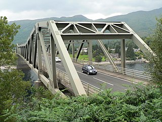
The Ballachulish Bridge is a bridge in the West Highlands of Scotland.

Ben Nevis and Glen Coe is a national scenic area (NSA) covering part of the Highlands of Scotland surrounding Ben Nevis and Glen Coe, in which certain forms of development are restricted. It is one of 40 such areas in Scotland, which are defined so as to identify areas of exceptional scenery and to ensure its protection from inappropriate development. The Ben Nevis and Glen Coe NSA covers 903 km2 (349 sq mi) of land, lying within the Highland, Argyll and Bute and Perth and Kinross council areas. A further 19 km2 (7.3 sq mi) of the NSA are marine, covering the sea loch of Loch Leven.