Benbecula is an island of the Outer Hebrides in the Atlantic Ocean off the west coast of Scotland. In the 2011 census, it had a resident population of 1,283 with a sizable percentage of Roman Catholics. It is in a zone administered by Comhairle nan Eilean Siar or the Western Isles Council. The island is about 12 kilometres from west to east and a similar distance from north to south. It lies between the islands of North Uist and South Uist and is connected to both by road causeways. Benbecula's main settlement and administrative centre is Balivanich.

Glencoe or Glencoe Village is the main settlement in Glen Coe in the Lochaber area of the Scottish Highlands. It lies at the north-west end of the glen, on the southern bank of the River Coe where it enters Loch Leven.

Lochaber is a name applied to a part of the Scottish Highlands. Historically, it was a provincial lordship consisting of the parishes of Kilmallie and Kilmonivaig, as they were before being reduced in extent by the creation of Quoad Sacra parishes in the 19th century. Lochaber once extended from the Northern shore of Loch Leven, a district called Nether Lochaber, to beyond Spean Bridge and Roybridge, which area is known as Brae Lochaber or Braigh Loch Abar in Gaelic. Lochaber is now also used to refer to a much wider area, one of the 16 ward management areas of the Highland Council of Scotland and one of eight former local government districts of the two-tier Highland region. The main town of Lochaber is Fort William.
Lismore is an island of some 2,351 hectares in the Inner Hebrides of Scotland. The climate is damp and mild, with over 166 centimetres (65 in) of rain recorded annually. This fertile, low-lying island was once a major centre of Celtic Christianity, with a 6th-century monastery associated with Saint Moluag, and later became the seat of the medieval Bishop of Argyll. There are numerous ruined structures, including a broch and two 13th-century castles.

Argyll, sometimes called Argyllshire, is a historic county and registration county of western Scotland.

Loch Leven is a sea loch located on the west coast of Scotland. It is spelled Loch Lyon in Timothy Pont's map of the area and is pronounced Li' un. The local Gaelic pronunciation is Lee' oon

The village of Ballachulish in Lochaber, Highland, Scotland, is centred on former slate quarries. The name Ballachulish was more correctly applied to the area now called North Ballachulish, to the north of Loch Leven, but was usurped for the quarry villages at East Laroch and West Laroch, either side of the River Laroch, which were actually within Glencoe and South Ballachulish respectively.
Glen Coe is a glen of volcanic origins, in the Highlands of Scotland. It lies in the north of the county of Argyll, close to the border with the historic province of Lochaber, within the modern council area of Highland. Glen Coe is regarded as the home of Scottish mountaineering and is popular with hillwalkers and climbers.

The Battle of the Shirts was a Scottish clan battle that took place in 1544 in the Great Glen, at the northern end of Loch Lochy. The Clan Macdonald of Clanranald and their allies the Clan Cameron fought the Clan Fraser and men from Clan Grant. The battlefield has been included and protected by Historic Scotland in their Inventory of Historic Battlefields in Scotland.
Chì mi na mòrbheanna is a Scottish Gaelic song that was written in 1856 by Highlander John Cameron, a native of Ballachulish and known locally in the Gaelic fashion as Iain Rob and Iain Òg Ruaidh. He worked in the slate quarries before moving to Glasgow where he was engaged as a ship's broker. He became the Bard of the Glasgow Ossianic Society and also Bard to Clan Cameron. He returned to carry on a merchant's business along with his elder brother and to cultivate a small croft at Taigh a' Phuirt, Glencoe, in his beloved Highlands. Other songs and odes appeared in The Oban Times and in various song books. He was buried in St. Munda's Isle in Loch Leven. Wreaths of oak leaves and ivy covered the bier The song is a longing for home and, with its wistful, calming melody and traditional ballad rhythms, is often used as a lullaby.
Clan Stewart of Appin is the West Highland branch of the Clan Stewart and have been a distinct clan since their establishment in the 15th century. Their Chiefs are descended from Sir James Stewart of Perston, who was himself the grandson of Alexander Stewart, the fourth High Steward of Scotland. His cousin Walter Stewart, the 6th High Steward, married Marjorie Bruce, the daughter of King Robert the Bruce, and their son Robert II was the first Stewart Monarch. The Stewarts of Appin are cousins to the Royal Stewart Monarchy.

Clan Macfie is a Highlands Scottish Clan.
This is a list of islands called Eilean Fraoch or Fraoch Eilean, which provides an index for islands in Scotland with this and similar names. Literally meaning "heather island" in Scottish Gaelic, it is a common Scottish island name. It may also represent the forename "Fraoch" from Gaelic mythology.

Finlaggan is a historic site on Eilean Mòr in Loch Finlaggan. The Loch, the island, and Finlaggan Castle lie on Islay, around two kilometres to the northwest of Ballygrant.

Inverness-shire is a historic county, registration county and lieutenancy area of Scotland. Covering much of the Highlands and Outer Hebrides, it is Scotland's largest county, though one of the smallest in population, with 67,733 people or 1.34% of the Scottish population.
Fraoch Eilean/Ejlean is a small island situated at the northern end of Loch Awe, a freshwater lake in Argyll and Bute, Scotland. It is notable for being the site of a medieval royal castle, now ruined, which was given into the keeping of Clan Macnaghten by Alexander III in 1267.
Eilean Mòr is one of the MacCormaig Isles situated near the entrance to Loch Sween in the Sound of Jura, Argyll and Bute, Scotland. Eilean Mòr is uninhabited.

Duror, occasionally Duror of Appin, is a small, remote coastal village that sits at the base of Glen Duror, in district of Appin, in the Scottish West Highlands, within the council area of Argyll and Bute in Scotland. Duror is known for the first building of the Telford Parliamentary churches by the Scottish civil engineer, architect and stonemason, Thomas Telford, from 1826, the first in a series of 32, built in Scotland. William Thomson was the architect. Duror is the location of the famous Appin Murder. Although no direct evidence for this connection exists, the murder event and the kidnap of James Annesley, supposedly provided the inspiration for Robert Louis Stevenson writing the novel Kidnapped.

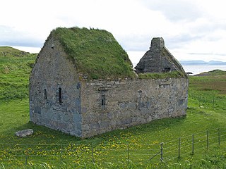
Saint Munde was a Scottish abbot in Argyll, Scotland. There is some confusion between this saint and the much earlier Saint Fintan Munnu. His feast day is 15 April.