
The River Witham is a river almost entirely in the county of Lincolnshire in the east of England. It rises south of Grantham close to South Witham at SK8818, passes through the centre of Grantham, passes Lincoln at SK9771 and at Boston, TF3244, flows into The Haven, a tidal arm of The Wash, near RSPB Frampton Marsh. The name "Witham" seems to be extremely old and of unknown origin. Archaeological and documentary evidence shows the importance of the Witham as a navigable river from the Iron Age onwards. From Roman times it was navigable to Lincoln, from where the Fossdyke was constructed to link it to the River Trent. The mouth of the river moved in 1014 following severe flooding, and Boston became important as a port.
The River Hull is a navigable river in the East Riding of Yorkshire in Northern England. It rises from a series of springs to the west of Driffield, and enters the Humber Estuary at Kingston upon Hull. Following a period when the Archbishops of York charged tolls for its use, it became a free navigation. The upper reaches became part of the Driffield Navigation from 1770, after which they were again subject to tolls, and the section within the city of Hull came under the jurisdiction of the Port of Hull, with the same result.

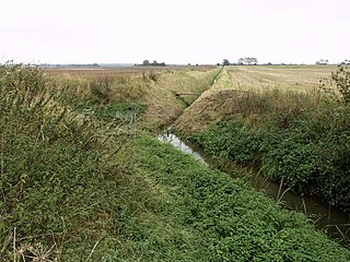
A ditch is a small to moderate trench created to channel water. A ditch can be used for drainage, to drain water from low-lying areas, alongside roadways or fields, or to channel water from a more distant source for plant irrigation. Ditches are commonly seen around farmland, especially in areas that have required drainage, such as The Fens in eastern England and much of the Netherlands.

Tai Lam Country Park, established on 23 February 1979, is a country park located in Tai Lam, at the south of Yuen Long Town, Kam Tin and Shek Kong and east of Tuen Mun Town, in the western New Territories of Hong Kong. This country park has an area of 54 km².

Arram Beck is a small stream in the East Riding of Yorkshire, England, running through high embankments and flowing eastwards from the village of Arram to join the River Hull. Depths are variable due to the tidal nature of the Hull. It provides habitat for a variety of fish species and chub have also been stocked here too.
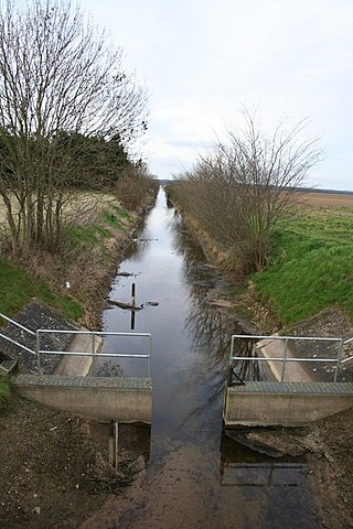
A catchwater drain is a land drain, a ditch cut across the fall of the land, typically just above the level of low-lying, level ground such as The Fens of eastern England, where some land, tens of kilometres from the sea is at about sea level. Its purpose is to gather water draining from the higher, sloping ground before it reaches the flat land whence it would be difficult or expensive to remove. The water may be on the surface, in streams or in the ground before it is gathered, perhaps to be led away across the lowland by an embanked river.

Great Shunner Fell is the third-highest mountain in the Yorkshire Dales, North Yorkshire, England, and the highest point in Wensleydale; at 716 metres above sea level. In clear weather the summit affords views of Wensleydale to the south, Ribblesdale to the southwest and Swaledale to the north, as well as views into Cumbria and County Durham beyond the A66.

A catchwater device is a large-scale man-made device for catching surface runoff from hills and the sky from precipitation by channeling it to reservoirs for commercial and domestic use later. Freshwater is a scarce natural resource due to pollution, droughts, and overpopulation. Catchwater is a sustainable mechanism to increase freshwater in areas facing droughts or polluted waterways. A catchwater drain decreases the velocity of storm-water runoff to reduce and prevent erosion and other environmental problems.

Aike Beck or the Lockington Navigation was a stream in the East Riding of Yorkshire, England, which was constructed as a navigation in the late 18th century, and ceased to function as such in the 1850s. The water supply came from Bryan Mills Beck and Scorborough Beck, but in 1988, these were diverted to feed into Arram Beck, and most of the channel was filled in with material from the flood banks.
Artle Beck is a minor river of Lancashire, England.

Beverley Beck is a short canal in the East Riding of Yorkshire, England. The beck runs from Grovehill Lock on the River Hull at Beverley west for about 0.8 miles (1.3 km) into the town of Beverley. Until 1802, the beck was tidal, but the Beverley and Barmston Drain needed to pass under it, and the lock was constructed to maintain water levels over its tunnel. In 1898, a steam engine was installed, which could be used to top up the water levels in the beck by pumping water from the River Hull. A multimillion-pound refurbishment of the area concluded in 2007, with the refurbishment of the lock gates and pumping engine.
The River Greta is a river in County Durham, England. It is a tributary of the River Tees and flows through the northern part of the old North Riding of Yorkshire. The name "Greta" derives from the Old Norse "Griótá", meaning "stony stream".
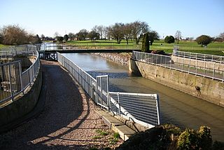
The Witham Navigable Drains are located in Lincolnshire, England, and are part of a much larger drainage system managed by the Witham Fourth District Internal Drainage Board. The Witham Fourth District comprises the East Fen and West Fen, to the north of Boston, which together cover an area of 97 square miles (250 km2). In total there are over 438 miles (705 km) of drainage ditches, of which under 60 miles (97 km) are navigable. Navigation is normally only possible in the summer months, as the drains are maintained at a lower level in winter, and are subject to sudden changes in level as a result of their primary drainage function, which can leave boats stranded. Access to the drains is from the River Witham at Anton's Gowt Lock.

Arkle Beck is the stream running through the valley of Arkengarthdale in the Yorkshire Dales, England. It is a tributary of the River Swale, which it joins just past Reeth at Grinton Bridge. The beck itself has several tributaries which include:

Stixwould is a small village in the civil parish of Stixwould and Woodhall, in the East Lindsey district of Lincolnshire, England.
The Minster Way is a 50-mile (80 km) walking route between the Minsters of Beverley and York in England. It crosses the chalk hills of the Yorkshire Wolds, as well as a wide variety of the East Riding of Yorkshire countryside. Part of the route follows the Yorkshire Wolds Way National Trail across Sylvan Dale before diverting to Millington, Bishop Wilton and Stamford Bridge, where it follows the River Derwent into the Plain of York as far as the River Ouse.
The River Foulness is a river in the East Riding of Yorkshire, England. Its name is derived from Old English fūle[n] ēa, meaning “dirty water”. Maintenance responsibilities for the river transferred from the Environment Agency to the Market Weighton Drainage Board on 1 October 2011. Market Weighton Drainage Board subsequently amalgamated with the Lower Ouse Internal Drainage Board on 1 April 2012 to create the Ouse and Humber Drainage Board. The river discharges into the Humber Estuary via Market Weighton Canal. Water levels within the river, its tributaries and the canal are managed and controlled by the Environment Agency. The river lies in an area known as the Humberhead Levels.

The River Torne is a river in the north of England, which flows through the counties of South Yorkshire and North Lincolnshire. It rises at the Upper Lake at Sandbeck Hall, in Maltby in South Yorkshire, and empties into the River Trent at Keadby pumping station. Much of the channel is engineered, as it plays a significant role in the drainage of Hatfield Chase, which it crosses.
