Greatford is a village and civil parish in the South Kesteven district of Lincolnshire, England.[1] It is situated 2 miles (3km) west from the A15, 4.5 miles (7km) north-east from Stamford, and 5 miles (8km) south from Bourne. Greatford is noted for Greatford Hall, once the home of the priest and physician Francis Willis.
In the 2001 Census, Greatford's population was found to be 260,[2] increasing slightly to 268 at the 2011 census.[3]
History
There are different pronunciations and spellings for this village's name, including Greatford, Gritford, and Gretford.[4] The name could be derived from its location on a gravel or 'grit' ford of the West Glen River.[4]
Greatford is listed in the Domesday Book of 1086 as "Greteford" and "Griteford".[4]
The parish contains the now untraceable medieval hamlet of Banthorp, also mentioned in the Domesday Book. A 1334 tax list puts the site of Banthorp to the west of Greatford at Banthorpe Woods and Lodge.[5]
In October 1892 a granary full of barley collapsed at the farm of the Dean family, killing four people: two from Greatford, one from Langtoft and one from Market Deeping.[6]
Landmarks
Greatford Grade I listed church, built in Early English style, dedicated to St Thomas of Canterbury.[7][8] It is part of the Uffington Group of the Deanery of Aveland & Ness with Stamford. The incumbent is the Rev'd Carolyn Kennedy.[9] The church was previously part of the Greatford with Wilsthorpe Group.
Greatford Hall was originally a manor house built during the reign of Queen Elizabeth I in the 16th century. It was the home and private asylum for Francis Willis, the physician who treated and 'cured' King George III of his 'madness' here in 1788. In 1922 the hall burned down and was subsequently rebuilt in a similar style to the original. There is no public access to the hall today.[4]
During the Second World War the Hall was owned by Lancaster Gate Hotels. In the 20th century Greatford Hall was the residence of the businessman Harry Dowsett who, in 1943, formed the civil engineering company Dow-Mac that first developed the use of prestressed concrete, made at Tallington2 miles (3.2km) to the south of Greatford. The company is now Tarmac Precast Concrete. In 1940 Dowsett bought the Lowestoft-based firm of shipbuilders, Brooke Marine that made Royal Navy landing craft during the Second World War.
The village public house is the Hare and Hounds on Village Street. Serving Landlords compiled by Mrs 'Sunny' Mason, resident of Greatford for 80 years:
Landlords unknown prior to 1890. 1890 – 1900 Mr & Mrs Starkie, 1903 – 1928 Mr & Mrs Barnes, 1940 – 1944 Reg & Martha Simpkins, 1945 – 1951 Tom & Sylvia Bills, 1952 – 1962 Earnie & Doris Groves, 1962 – 1968 Jock & Jean Brown, 1968 – 1971 Keith & Sylvia ( Surname unknown)Button?, 1971 – 1975 Ted & Joan Pass, 1975 – 1978 Malcolm & Jane Mills, 1978 – 1979 Kay & Tim (Surname unknown), 1979 – 1980 Dave Medcalf, 1980 – 1981 Alf Button, 1981 – 1984 Peter & Valerie Wilkins, 1984 – 1985 Nigel & Melinda Dawkins, 1985 – 1986 Mr & Mrs Simpson (Brewery Managers), 1986 – 1987 Ricky & Olga Podmore, 1987 – 1989 John & Pat Vasey, 1989 – 1990 Michael Thurlby, 1990 – 1993 Nigel & Melinda Dawkins, 1999 – 2006 Nick & Bridie Hards, 2006 – 2010 Gemma Dixie, 2011 – to date Steven Rigby & Alexandra Faux.
Geography
To the west, the parish boundary meets Braceborough and Wilsthorpe to the north, passing through Banthorpe Lodge, crossing the East Coast Main Line, then following the West Glen River through Shillingthorpe Park. Close to the village near Greatford Hall, the boundary passes north, crossing the road to Carlby. It follows part of the Macmillan Way (which passes straight through the parish, broadly following the Glen) near some coppices. It rejoins the West Glen River, crossing the road to Wilsthorpe. East of Fletland Mill, it meets Thurlby (Obthorpe).[10]
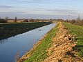
At the A15 bridge over the West Glen River, where the Macmillan Way crosses, it meets Baston, to the east. The boundary now follows the Roman roadKing Street, and the King Street Drain, to the south. For 200 metres it meets Langtoft, then meets Barholm and Stowe, and leaves King Street to the west, passing through some coppices. north of Barholm, it briefly follows the Greatford Cut, a navigation built in 1954 to connect the West Glen River, to the north at Greatford, with the River Welland west of Market Deeping, and to stop the River Glen from flooding. It passes north of Maidens' Farm and at the East Coast Main Line meets Uffington, passing along the southern edge of Browne's Oaks.[10]
The highest part of the parish is just above the 20m contour in the North west. The village and the remaining farmland is rather lower, perhaps less than 15m. (there is a 12m spot height for the village itself on the OS map)[10]
The underlying geology of the parish is Sedimentary: to the South and East is of a Kellaways sand and siltstone.mix, and to the North and West a Kellaways clay deposit where the land rises at the western edge of the Parish. The whole is overlaid with Quaternary 'river terrace' sands and gravels dating back 1 or 2 million years. Unlike Tallington to the south, there has been no extraction of these deposits in Greatford. From the south west to the Northwest the west Glen river lies in a shallow valley, its floodplain formed of its own alluvium of clay and silt.[11]
Greatford is served by a Parish Council, two District Councillors who represent Casewick Ward on South Kesteven District Council and a County Councillor representing Deepings West & Rural Division on Lincolnshire County Council. The current District Councillors elected in 2015 are Kelham Cooke (Con) and Rosemary Trollope-Bellew (Con). The Lincolnshire County Councillor elected in 2017 is Rosemary Trollope-Bellew (Con).
The River Glen is a river in Lincolnshire, England with a short stretch passing through Rutland near Essendine.
South Kesteven is a local government district in Lincolnshire, England, forming part of the traditional Kesteven division of the county. Its council is based in Grantham. The district also includes the towns of Bourne, Market Deeping and Stamford, along with numerous villages and surrounding rural areas.
Market Deeping is a market town and civil parish in the South Kesteven district of Lincolnshire, England, on the north bank of the River Welland and the A15 road. The population of the town at the 2011 census was 6,008.
Uffington is a village and civil parish in the South Kesteven district of Lincolnshire, England. The population of the civil parish at the 2011 census was 686. It is in the valley of the River Welland, between Stamford and The Deepings.
Grantham and Stamford was a constituency in Lincolnshire represented in the House of Commons of the UK Parliament from 1997 to 2024.
Baston is a village and parish on the edge of The Fens and in the administrative district of South Kesteven, Lincolnshire, England. The 2011 census reported the parish had 1,469 people in 555 households.
Thurlby is a village and civil parish in the South Kesteven district of Lincolnshire, England. It is situated just west of the A15 road, 2 miles (3 km) south from the town of Bourne, and on the edge of the Lincolnshire Fens. It is sometimes referred to as Thurlby by Bourne to distinguish it from other villages in Lincolnshire with the same name. Thurlby and the hamlet of Northorpe to its north are conjoined. The parish had a population of 2,136 at the 2001 census and 2,153 at the 2011 census.
Braceborough and Wilsthorpe is a civil parish in the South Kesteven district of Lincolnshire, England. Braceborough and Wilsthorpe are less than 1 mile (1.6 km) apart, separated by the East Glen River. Braceborough and Wilsthorpe are located between the A6121 road, which goes from Stamford to Bourne, and the A15, this links Bourne and Market Deeping. It is approximately 12 miles (19 km) north-west from its nearest city, Peterborough. Before the 1930s Braceborough and Wilsthorpe were separate parishes but in 1931 the two were dissolved and joined together to form today's civil parish.
Braceborough is a village in the civil parish of Braceborough and Wilsthorpe, in the South Kesteven district of Lincolnshire, England. It is situated off the Stamford to Bourne A6121 road, just west of the A15 as it runs between Market Deeping and Bourne. In 1921 the parish had a population of 150. On 1 April 1931 the parish was abolished and merged with Wilsthorpe to form "Braceborough and Wilsthorpe".
Uffington was a rural district in Lincolnshire, Parts of Kesteven from 1894 to 1931.
The Deepings School is a coeducational secondary school and sixth form with academy status, located on Park Road in Deeping St James in Lincolnshire, England. As of April 2022, the school is attended by almost 1,500 pupils aged 11 to 18 taught by 90 teaching staff. It includes pupils from Stamford, Spalding, Langtoft, Baston, Bourne and the Deeping area.
Langtoft is a village and civil parish in the South Kesteven district of Lincolnshire, England. The population of the civil parish at the 2021 census was 2,008. It lies on the A15 road, about 10 miles (16 km) north from Peterborough and about 8 miles (13 km) east from Stamford, and on the edge of The Fens.
Barholm is a village in the civil parish of Barholm and Stowe, in the South Kesteven district of Lincolnshire, England. It is 2 miles (3 km) west from the A15 road, and 6 miles (10 km) south from Bourne. In 1921 the parish had a population of 170.
Tallington is a village and civil parish in the South Kesteven district of Lincolnshire, England. The population of the civil parish at the 2011 census was 497. It is situated 4 miles (6 km) east from Stamford and 8 miles (13 km) north-west from the centre of Peterborough. The village has around 200 houses.
The A6121 is a short cross-country road in the counties of Lincolnshire and Rutland, England. It forms the principal route between Bourne and Stamford and the A1 in Lincolnshire, continuing on through Ketton in Rutland to its junction with the A47 at Morcott. Its south-western end is at 52°35.5860′N0°38.0820′W and its north-eastern end is at 52°45.9120′N0°24.0660′W. The road has increased in importance with the rapid expansion of housing in this part of South Kesteven.
Wilsthorpe is a village in the civil parish of Braceborough and Wilsthorpe, in the South Kesteven district, in the county of Lincolnshire, England. It is situated approximately 6 miles (10 km) north-east from Stamford and approximately 4 miles (6 km) south from Bourne.
The A1175 road is a road in south-west Lincolnshire, England. It runs between Stamford and Spalding, along the old A16 route.
1 2 3 Bourne & Heckington:Billingborough & Morton (Map) (A1ed.). 1:25 000. OS Explorer. Ordnance survey of Great Britain. 3 January 2006. §248. ISBN9780319238110.
↑ "Geology of Britain viewer". British Geological survey. Archived from the original on 2 December 2016. Retrieved 12 September 2013.Zoom to the location, click to identify the geology.
This page is based on this Wikipedia article Text is available under the CC BY-SA 4.0 license; additional terms may apply. Images, videos and audio are available under their respective licenses.