
Bourne is a market town and civil parish in the South Kesteven district of Lincolnshire, England. It lies on the eastern slopes of the limestone Kesteven Uplands and the western edge of the Fens, 11 miles (18 km) north-east of Stamford, 12 miles (19 km) west of Spalding and 17 miles (27 km) north of Peterborough. The population at the 2011 census was 14,456. A 2019 estimate put it at 16,780.

Ryhall is a village and civil parish in the county of Rutland in the East Midlands of England. It is situated close to the eastern boundary of the county, about 2 miles (3 km) north of Stamford. The parish includes the hamlet of Belmesthorpe.

Deeping St James is a large village in the South Kesteven district of Lincolnshire, England. The population of the civil parish was reported as 7,051 at the 2011 census.

Denton is a village and civil parish in the South Kesteven district of Lincolnshire, England. The population of the civil parish was 273 at the 2011 census. It is situated approximately 3 miles (5 km) both south-west of Grantham and west from the A1 road.

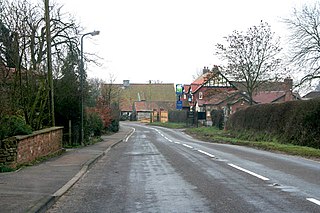
Essendine is a village and civil parish at the eastern end of the county of Rutland in the East Midlands of England, located 5 miles north of Stamford and 6 miles south of Bourne. The population of the civil parish at the 2011 census was 448. It lies on the West Glen, close by the earthworks of a small castle.
Dowsby is a village and civil parish in the South Kesteven district of Lincolnshire, England. It is situated on the western edge of The Fens at the junction of the east–west B1397 road and the north–south B1177. It is 1 mile (1.6 km) north-east from Rippingale and just south of Pointon. The civil parish includes the hamlet of Graby. Nearby to the east, along the B1397 at Dowsby Fen, is Car Dyke. The civil parish population taken at the 2011 census was 204.

Aslackby and Laughton is a civil parish in the South Kesteven district of Lincolnshire, England. According to the 2001 census the parish had a population of 243, in 102 households. increasing slightly to 251 in 118 households at the 2011 census. It consists of the village of Aslackby, the hamlet of Laughton, and scattered farms, and part of the hamlet of Graby.

Burton Coggles is a small village and civil parish in the South Kesteven district of Lincolnshire, England. The population is included in the civil parish of Bitchfield and Bassingthorpe. The village is situated 7 miles (11 km) south from Grantham, and between the B1176 road and the East Coast Main Line.

Braceborough and Wilsthorpe is a civil parish in the South Kesteven district of Lincolnshire, England. Braceborough and Wilsthorpe are less than 1 mile (1.6 km) apart, separated by the East Glen River. Braceborough and Wilsthorpe are located between the A6121 road, which goes from Stamford to Bourne, and the A15, this links Bourne and Market Deeping. It is approximately 12 miles (19 km) north-west from its nearest city, Peterborough. Before the 1930s Braceborough and Wilsthorpe were separate parishes but in 1931 the two were dissolved and joined together to form today's civil parish.

Castle Bytham is a village and civil parish of around 300 houses in South Kesteven, Lincolnshire, England. It is located 9 miles (14 km) north of Stamford and 9 miles (14 km) west of Bourne. The population was measured at 768 in 317 households at the 2011 census.

Greatford is a village and civil parish in the South Kesteven district of Lincolnshire, England. It is situated 2 miles (3 km) west from the A15, 4.5 miles (7 km) north-east from Stamford, and 5 miles (8 km) south from Bourne. Greatford is noted for Greatford Hall, once the home of Francis Willis.
Edenham is a village and civil parish in the South Kesteven district of Lincolnshire, England. It is approximately 3 miles (5 km) north-west of Bourne, and on the A151 road. While the civil parish is called 'Edenham', the parish council is called Edenham, Grimsthorpe, Elsthorpe & Scottlethorpe Parish Council. The population of the civil parish at the 2011 census was 291.
Little Bytham is a village and civil parish in the South Kesteven district of Lincolnshire, England. The population of the civil parish at the 2011 census was 384. It lies on the B1176 road, 4 miles (6 km) south from Corby Glen and 6 miles (10 km) north from Stamford.

Wyville is a village in the civil parish of Wyville cum Hungerton, in the South Kesteven district of Lincolnshire, England, and situated approximately 5 miles (8 km) south-west from Grantham The whole parish covers about 1,670 acres (6.8 km2). The population is included in the civil parish of Little Ponton and Stroxton.

Swayfield is a village and civil parish in the South Kesteven district of Lincolnshire, England. The population of the civil parish at the 2011 census was 316. It is situated just over 3 miles (5 km) east from the A1 road, 9 miles (14 km) south-east from Grantham and 10 miles (16 km) north from Stamford. It has approximately 138 houses.

The A6121 is a short cross-country road in the counties of Lincolnshire and Rutland, England. It forms the principal route between Bourne and Stamford and the A1 in Lincolnshire, continuing on through Ketton in Rutland to its junction with the A47 at Morcott. Its south-western end is at 52°35.5860′N0°38.0820′W and its north-eastern end is at 52°45.9120′N0°24.0660′W. The road has increased in importance with the rapid expansion of housing in this part of South Kesteven.
Carlton Scroop is a small village and civil parish in the South Kesteven district of Lincolnshire, England. The population of the civil parish at the 2011 census was 304. It is situated 6 miles (10 km) north-east from the market town of Grantham and 4 miles (6 km) east from the village of Hougham. The A607 road to Lincoln passes through the centre of the village.
Old Somerby is a village and civil parish in the South Kesteven district of Lincolnshire, England, 3 miles (5 km) south-east of Grantham. It lies on the B1176 road, with the village centre about 1 mile (1.6 km) east of its junction with the A52 and B6403, and adjacent to the East Coast Main Line.
Careby Aunby and Holywell is a civil parish in the district of South Kesteven, south-west Lincolnshire, in England. It stretches from the county border with Rutland in the west to the River West Glen in the east. The B1176 road from Corby Glen passes through Careby and on past Aunby toward Stamford. The main London to Scotland railway line passes through the parish, the line upon which Mallard took the speed record for the LNER.

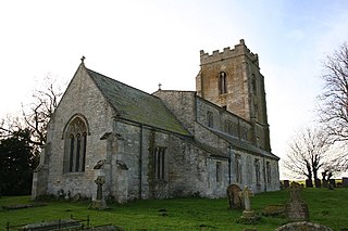
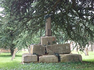
The Church of St Andrew in Folkingham, Lincolnshire, England, is Grade I–listed Anglican church. Originating in the late 12th century, it was largely completed by the late 15th, with restorations carried out in 1825, 1858 and 1860. It has early Decorated style arcades and a mainly Early English chancel, with a Norman pier where there was an opening into a chantry chapel. On the south side of the church are the remains of stocks and a whipping-post.

