Kingsdale

Last updated

Kingsdale
Kingsdale Head - geograph.org.uk - 66203.jpg
Kingsdale Head
North Yorkshire UK location map (2023).svg
Red pog.svg
Kingsdale
Floor elevation857 feet (261.3 m) [1]
Length5.5 miles (8.9 km)
Geography
CountryEngland
State/ProvinceNorth Yorkshire
Coordinates 54°11′35″N2°27′25″W / 54.193°N 2.457°W / 54.193; -2.457 [1]

Kingsdale is a valley on the western edge of the Yorkshire Dales National Park in northern England. The name Kingsdale derives from a combination of Old Norse and Old English (Kyen and Dael) which means The valley where the cows were kept. [2] [3] Humans were active in Kingsdale from 6,700 BC onwards. Evidence of fire-pits used by hunter-gatherers have been found in the dale.

Contents

History

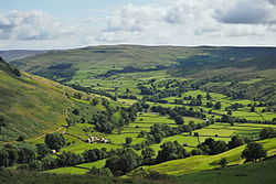
Kingsdale is a short narrow dale, that measures 5.5 miles (8.9 km) from Thornton-in-Lonsdale in the south, to High Moss in the north. [4] During the Last Glacial Maximum, when many of the dales were affected by ice, a glacier carved out the valley of Kingsdale, and left behind a lake impounded at its southern end by a terminal moraine Raven Ray, a piece of land higher than the broad valley beyond it. [5] [6] The presence of fire-pits in the dale dating back to the Mesolithic era (6850–6840 BC), provide evidence of humans using the dale, but only for hunting during the summer months, with the people expected to be from the lowlands. [7] [8] More permanent occupancy of the dale occurred during the Bronze Age, with sooty mounds found in Kingsdale dating back to 1500 BC. The mounds consist of ash, charcoal, sooty remnants and rock fragments, though it is unclear what the mounds were for. [9] Another named mound is the Apron Full of Stones, the local legend being that the stones fell from the devil's apron. The site was excavated in 1972 and is a Bronze Age burial mound, though not made with limestone boulders, but from gritstone from outside of the valley. [10]

The enclosing of the land in the valley around 1820, involved the reclamation of some areas, and the beck was also straightened. This gives the valley, what W. R. Mitchell calls, "..an unusually neat appearance." [11]

The larger part of the valley lies within the county of North Yorkshire but its highest reaches fall just within Cumbria. It is defined by the hills of Whernside to its east and Gragareth to its west. [12] Kingsdale is drained by the south-westward flowing Kingsdale Beck which assumes the name River Twiss before joining the River Doe at Ingleton to become the River Greta. [13] Two large waterfalls are on the lower reaches of the River Twiss; Thornton Force is 49 feet (15 m) high over one drop, whereas Pecca Falls are a series of waterfall drops covering 115 feet (35 m). [14] The ledge at the top of the waterfall of Thornton Force is made up of the Great Scar Limestone, the middle is cobbles from a sea of the Carboniferous period (350 million years ago), and the lower part, where the basin is, is composed of Ordovician slate which dates back 530 million years. [15]

Kingsdale Beck is frequently dry on the surface between Kingsdale Head and Keld Head, with the water travelling underground before resurfacing at Keld Head. The same thing happens to the River Skirfare in Littondale. [16] Spells of wet weather often bring about a wall of water that travels down the valley across the dry riverbed. [17]

The single minor public road which serves the valley is an old packhorse route that connected Ingleton with Deepdale, then Dentdale, and which also forms the NCR 68 and the Yorkshire Dales Cycle Way. [18] [19] [20] This road was a rough track until just after the Second World War, when it was re-laid with tarmac, and reaches a height of 1,552 feet (473 m). [21] On the west high ground of the valley is a track known as Turbary Road (turbary being an ancient right to cut peat or turf for fuel). The route is so named as it was where the peat-cutters would transport their peat down the valley. [4] There are several nationally important caves within the valley (such as Rowten Pot and Yordas Cave) [22] and the resurgence of Keld Head. Several other caves exist under the valley; Kail Pot, Swinsto Cave, King Pot, Jingling Pot, Valley Entrance, and Bull Pot. [23] [24]

Related Research Articles

<span class="mw-page-title-main">Yorkshire Dales</span> Upland area of the Pennines in Northern England

The Yorkshire Dales are a series of valleys, or dales, in the Pennines, a range of hills in England. They are mostly located in the ceremonial county of North Yorkshire, but extend into Cumbria and Lancashire; they were historically entirely within Yorkshire. The majority of the dales are within the Yorkshire Dales National Park, created in 1954. The exception is the area around Nidderdale, which forms the separate Nidderdale Area of Outstanding Natural Beauty.

<span class="mw-page-title-main">Craven District</span> Former local government district in England

Craven was a non-metropolitan district in the west of North Yorkshire, centred on the market town of Skipton.

<span class="mw-page-title-main">Ingleton, North Yorkshire</span> Village and civil parish in North Yorkshire, England

Ingleton is a village and civil parish in the Craven district of North Yorkshire, England. The village is 19 miles (30 km) from Kendal and 17 miles (28 km) from Lancaster on the western side of the Pennines. It is 9.3 miles (15 km) from Settle. The River Doe and the River Twiss meet to form the source of the River Greta, a tributary of the River Lune. The village is on the A65 road and at the head of the A687. The B6255 takes the south bank of the River Doe to Ribblehead and Hawes. All that remains of the railway in the village is the landmark Ingleton Viaduct. Arthur Conan Doyle was a regular visitor to the area and was married locally, as his mother lived at Masongill from 1882 to 1917. It has been claimed that there is evidence that the inspiration for the name Sherlock Holmes came from here.

<span class="mw-page-title-main">Rowten Pot</span>

Rowten Pot is one of several entrances into the 27-kilometre (17 mi) long cave system that drains Kingsdale in North Yorkshire, England. Its entrance is a shaft some 27 metres (89 ft) long, 10 metres (33 ft) wide, and at the southern end 72 metres (236 ft) deep.

<span class="mw-page-title-main">Chapel-le-Dale</span> Hamlet and civil parish in North Yorkshire, England

Chapel-le-Dale is a hamlet in the civil parish of Ingleton, North Yorkshire, England. It is in the Yorkshire Dales National Park in a valley of the same name, and was previously in the West Riding of Yorkshire.

<span class="mw-page-title-main">Halton Gill</span> Hamlet and civil parish in North Yorkshire, England

Halton Gill is a hamlet and civil parish in Littondale in the Yorkshire Dales in North Yorkshire, England. It is situated 2 miles (3.2 km) up Littondale from Litton. A minor road leads south west to Silverdale and Stainforth in Ribblesdale.

<span class="mw-page-title-main">River Skirfare</span> River in North Yorkshire, England

River Skirfare is a small river in North Yorkshire, England, that flows through Littondale and ends where it joins the larger River Wharfe. The source is the confluence of Foxup Beck and Cosh Beck at the hamlet of Foxup.

<span class="mw-page-title-main">River Twiss</span> River in North Yorkshire, England

The River Twiss is a river in the county of Yorkshire, England. The source of the river is Kingsdale Beck which rises at Kingsdale Head at the confluence of Back Gill and Long Gill in the Yorkshire Dales. Beneath Keld Head, it changes its name to the River Twiss. It has two notable waterfalls, Thornton Force and Pecca Falls, and its course follows part of the Ingleton Waterfalls Walk, then through Swilla Glen to Thornton in Lonsdale and down to Ingleton, where it meets the River Doe to form the River Greta.

<span class="mw-page-title-main">Scar End</span> Hamlet in North Yorkshire, England

Scar End is a settlement on the side of Twisleton Scar in the English county of North Yorkshire.

<span class="mw-page-title-main">Great Douk Cave</span> Cave in North Yorkshire, England

Great Douk Cave is a shallow cave system lying beneath the limestone bench of Ingleborough in Chapel-le-Dale, North Yorkshire, England. It is popular with beginners and escorted groups, as it offers straightforward caving, and it is possible to follow the cave from where a stream emerges at a small waterfall to a second entrance close to where it sinks 600 yards (549 m) further up the hill. It lies within the Ingleborough Site of Special Scientific Interest.

<span class="mw-page-title-main">Littondale</span> Dale in the former Craven District of North Yorkshire, England

Littondale is a dale in the former Craven District of the non-metropolitan county of North Yorkshire, England. It comprises the main settlements of Hawkswick, Arncliffe, Litton, Foxup and Halton Gill, and farmhouses that date from the 17th century. The main waterway in the dale is the River Skirfare which is fed by many small gills and becks.

<span class="mw-page-title-main">Craven Fault System</span> Geological faulting across the Craven District of North Yorkshire, England

The Craven Fault System is the name applied by geologists to the group of crustal faults in the Pennines that form the southern edge of the Askrigg Block and which partly bounds the Craven Basin. Sections of the system's component faults which include the North, Middle and South Craven faults and the Feizor Fault are evident at the surface in the form of degraded faults scarps where Carboniferous Limestone abuts millstone grit. The fault system is approximately coincident with the southwestern edge of the Yorkshire Dales National Park and the northeastern edge of the Bowland Fells.

<span class="mw-page-title-main">Yordas Cave</span> Cave in North Yorkshire, England

Yordas Cave is a solutional cave in Kingsdale, North Yorkshire, England. It has been renowned since the eighteenth century as a natural curiosity, and was a show cave during the nineteenth century. It is now a popular destination for cavers, walkers, and outdoor activity groups.

<span class="mw-page-title-main">Swinsto Cave</span> Cave in North Yorkshire, England

Swinsto Cave is a limestone cave in West Kingsdale, North Yorkshire, England. It leads into Kingsdale Master Cave and it is popular with cavers as it is possible to descend by abseiling down the pitches, retrieving the rope each time, and exiting through Valley Entrance of Kingsdale Master Cave at the base of the hill. It is part of a 27-kilometre (17 mi) long cave system that drains both flanks of Kingsdale.

<span class="mw-page-title-main">Scaleber Force</span> A waterfall near Settle in North Yorkshire, England

Scaleber Force, is a 40-foot (12 m) high waterfall on Stockdale Beck, later the Long Preston Beck, that feeds into the River Ribble between Settle and Long Preston in North Yorkshire, England. The waterfall is the result of geological faulting and is a popular tourist attraction.

<span class="mw-page-title-main">Crummackdale</span> A valley in North Yorkshire, England

Crummackdale,, is a small valley north of the village of Austwick in the Craven District of North Yorkshire, England. The Valley is drained by Austwick Beck, which flows into the River Wenning, which in turn heads westwards to empty into the Irish Sea. Crummackdale is a narrow south west facing dale, at the south west corner of the Yorkshire Dales National Park.

<span class="mw-page-title-main">Scoska Wood</span> National Nature Reserve in North Yorkshire, England

Scoska Wood is an IUCN Category IV – habitat or species management area, a British national nature reserve (NNR), and a Site of Special Scientific Interest (SSSI) in Littondale, North Yorkshire, England. It is a managed ancient woodland, known for its ash trees, grasses and moths. It was designated as an SSSI in 1975, and was awarded its IUCN status in 1992.

<span class="mw-page-title-main">Chapel-le-Dale (valley)</span> Valley in the Yorkshire Dales, England

Chapel-le-Dale is west-facing valley in the Yorkshire Dales, England. The U-shaped valley of Chapel-le-Dale is one of the few which drain westwards towards the Irish Sea, however, the river that flows through the valley has several names with the Environment Agency and the Ordnance Survey listing it as the River Doe. However, some older texts insist the name of the watercourse through the dale is the River Greta, which runs from a point below the hamlet of Chapel-le-Dale, and onwards past Ingleton. The dale is sparsely populated with only one settlement, the hamlet of Chapel-le-Dale, which has a small chapel.

<span class="mw-page-title-main">Cowside</span> Valley in North Yorkshire, England

Cowside is a side dale of Littondale in North Yorkshire, England. The valley, which faces in a north east direction, carries the waters of Cowside Beck to the River Skirfare at Arncliffe, draining an area of 8.9 square miles (23 km2), and flowing for 7.5 miles (12 km). Cowside is one of the few 'V'-shaped valleys in the Yorkshire Dales which had ice run across the valley, but not down it. The only settlement in the valley is Darnbrook, a very small hamlet at the foot of Darnbrook Fell. Cowside is a common name in the Craven area of the Yorkshire Dales, and it is not to be confused with the Cowside in Upper Wharfedale near Buckden, nor the Cowside Beck near Stainforth.

References

  1. 1 2 "Kingsdale, Craven - area information, map, walks and more". getoutside.ordnancesurvey.co.uk. Retrieved 2 March 2024.
  2. Chrystal 2017, p. 50.
  3. Metcalfe, Peter (1992). Place-names of the Yorkshire Dales: origins and meanings. Harrogate: North Yorkshire Marketing. p. 51. ISBN   1-873214-03-0.
  4. 1 2 Scholes, Ron (2011). Yorkshire Dales. Ashbourne: Horizon Press. p. 48. ISBN   9781843065081.
  5. Warren 2001, p. 77.
  6. Lee 2015, p. 36.
  7. Lee 2015, p. 50.
  8. Addison, Mike (18 December 2009). "Mystery Iron Age find is unearthed in Yorkshire Dales". The Westmorland Gazette. Retrieved 9 August 2019.
  9. Lee 2015, p. 51.
  10. Kelsall, Dennis (2017). The Yorkshire Dales: south and west : Wharfedale, Littondale, Malhamdale, Dentdale and Ribblesdale. Milnthorpe: Cicerone. p. 234. ISBN   9781852848859.
  11. Mitchell 1999, p. 22.
  12. "Weekend Walk: Turbary Road & Kingsdale". The Yorkshire Post. 28 January 2017. Retrieved 17 March 2018.
  13. Chrystal 2017, p. 103.
  14. Chrystal 2017, p. 106.
  15. Lee 2015, p. 23.
  16. Lee 2015, p. 230.
  17. Westcott, Matt (20 July 2017). "Video shows effects of heavy rain in Yorkshire Dales". The Northern Echo. Retrieved 6 March 2024.
  18. Warren 2001, p. 38.
  19. Ordnance Survey 1:63,360 scale Touring Map Yorkshire Dales
  20. Peace, Richard (1996). Yorkshire Dales Cycle Way. Keighley: Hillside. p. 34. ISBN   1870141288.
  21. Mitchell 1999, pp. 34, 60.
  22. Mitchell, Bill (20 November 2010). "The daring explorers of Craven's underworld". Craven Herald. Retrieved 9 August 2019.
  23. Kelsall, Dennis (2017). The Yorkshire Dales: south and west : Wharfedale, Littondale, Malhamdale, Dentdale and Ribblesdale. Milnthorpe: Cicerone. p. 232. ISBN   9781852848859.
  24. Lee 2015, p. 251.

Sources