Yordas Cave

Last updated

Yordas Cave
Yordas Cave - geograph.org.uk - 66192.jpg
The main entrance to Yordas Cave
Yorkshire Dales NP map-pre-2016.svg
Red pog.svg
Showing location of Yordas Cave in the Yorkshire Dales
Location Kingsdale, North Yorkshire, [UK]
OS grid SD 7055 7909
Coordinates 54°12′24″N2°27′09″W / 54.20659°N 2.452462°W / 54.20659; -2.452462 Coordinates: 54°12′24″N2°27′09″W / 54.20659°N 2.452462°W / 54.20659; -2.452462 [1]
Length230 metres (750 ft) [1]
Height variation43 metres (141 ft) [1]
Elevation312 metres (1,024 ft) [1]
GeologyCarboniferous limestone
Entrances5
Difficulty2 (3 for Yordas Pot) [1]
AccessNo permission is required [2]
Cave survey 1980 Gritstone Club survey on Cavemaps

Yordas Cave is a solutional cave in Kingsdale, North Yorkshire, England. It has been renowned since the eighteenth century as a natural curiosity, and was a show cave during the nineteenth century. It is now a popular destination for cavers, walkers, and outdoor activity groups. [3] [4]

Contents

Description

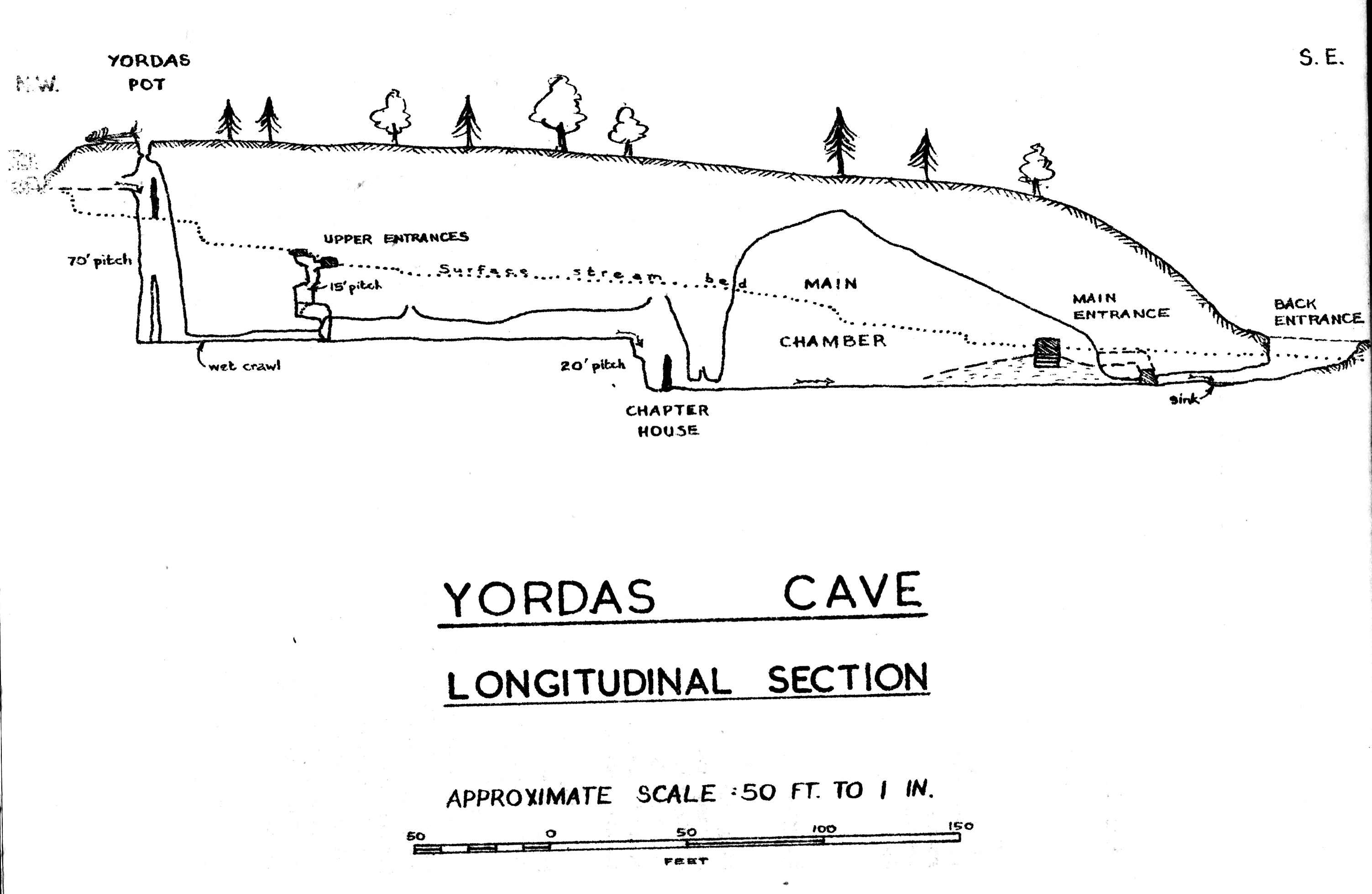
The old show cave entrance is in a plantation of trees 100 metres (330 ft) from the road, at the base of a small cliff, at the bottom of a small gorge. A flight of three steps descend from the entrance archway into the Main Chamber, 55 metres (180 ft) long, and 15 metres (49 ft) wide. A stream flows across the floor, and disappears into some low passages to the left. Also on the left, a low passage can be followed for a few metres to the Back Door entrance in a shakehole. At the upstream end of the chamber two passages soon unite in the spray-lashed Chapter House chamber, where a 9-metre (30 ft) waterfall enters and the showcave ended. Above the waterfall, a passage leads to a junction, with the water flowing from a low 20-metre (66 ft) long passage which leads to the base of Yordas Pot, an alternative entrance with a 24-metre (79 ft) shaft. The water enters from a side fissure just below the lip of the shaft. Turning right at the junction leads to a climb, and then to two entrances in the upper gorge. [1] [5] The shafts are equipped with resin P-hangers allowing the cave to be descended and ascended using standard single rope techniques (SRT). The route from the gorge to the bottom entrance may also be descended using canyoning-style techniques, with the last person down a pitch pulling down the rope. [6]

Etymology

The name Yordas is thought to come from the Old Norse ' Jörð á ', translated as 'earth stream'. [1] [7] The association with a giant called Yordas probably came from the tale recounted to John Hutton when being shown around the cave by the local guide in about 1780 "this place had formerly been the residence of a giant called Yordas; from which circumstance he accounts its name." [8] [9]

Geology and hydrology

Yordas Cave is a solutional cave formed in Visean Great Scar limestone from the Mississippian Series of the Carboniferous period. [10] Yordas Beck normally sinks at the top of the gorge, and reappears from a passage near the top of Yordas Pot. From the base of the shaft it follows the passage down to the Chapter House waterfall, before disappearing in confined passages at the end of the Main Chamber. In flood conditions a lake can rise in the Main Chamber up to 2 metres (6 ft 7 in) deep, before the water is able to flow out of the show cave entrance. [11] The underground stream next appears in Kingsdale Master Cave, and it resurges at Keld Head 2.7 kilometres (1.7 mi) down the valley. [1] The Main Chamber is several hundred thousand years old, and was formed by solution under phreatic conditions before the Kingsdale valley had formed and allowed it to drain. The square profile of the chamber has resulted from rock collapses from joints. A number of different false floors which may still be seen clinging to the walls indicate that the cave was subject to cycles of deposition and re-excavation during the recent ice ages. [5]

History

Yordas Cave was first described in detail by Richard Pococke who undertook a tour of Yorkshire in 1751, describing it as "a very grand high cave", [12] although it must have been well known to locals before then as on a visit around 1900 William Palmer noted inscriptions on the wall dating back to 1653. [13] It is marked on Thomas Jefferys 1771 map of Yorkshire, [14] and it was drawn to the public's attention in 1780 by John Hutton in an appendix to Thomas West's "A Guide to the Lakes". [15] He described stopping at Thornton at the bottom of the dale "to procure a guide, candle, tinderbox etc", and he also noted inscriptions "above two hundred years old". By this time the features in the cave had all already acquired the names by which they are known today. Hutton's guide recounted the tale that about fifty years earlier, a pregnant woman travelling alone was taken in labour, and died in the cave. [9] After the publication of Hutton's description, it became a destination for those seeking the picturesque, and is featured in most later guide books of the area, and is often described in magazines. [16] William Wordsworth visited the cave in 1800, and later referred to it in The Prelude , [17] and J. M. W. Turner sketched its exterior and interior in 1816. [18] In July 1817 a devastating flood filled much of the chamber with debris. The guide of the time removed some to expose the stream once more, but much of the height of the chamber was lost. [19] In 1818, William Westall produced a book of aquatinted engraved views of Yorkshire which included three views of Yordas Cave. [20] It was still a showcave when Balderstone visited in around 1890. He had to apply to Braida Garth, the farmhouse 2 kilometres (1.2 mi) down the dale, for the key and a guide and was charged two shillings. [21] The first through trip from the entrance in the upper gorge was made in 1925 by a Yorkshire Ramblers' Club party, [22] accompanied by author Laurence Geoghegan who apparently made full use of the experience when writing his novel The Subterranean Club. [23] The Back Door Entrance was opened up by members of the Northern Cavern and Fell Club in August 1932, when they referred to it as Scotsman's Entrance. [24] The Yordas Pot entrance appeared after a storm in December 1963 when a tree covering the shaft was blown over, and it was descended the following February by members of the Gritstone Club, [25] although the base of the shaft had previously been reached by members of the Northern Speleological Group in November 1959. [26]

Related Research Articles

Rowten Pot

Rowten Pot is one of several entrances into the 27-kilometre (17 mi) long cave system that drains Kingsdale in North Yorkshire, England. Its entrance is a shaft some 27 metres (89 ft) long, 10 metres (33 ft) wide, and at the southern end 72 metres (236 ft) deep.

Marble Arch Caves Limestone caves in Northern Ireland

The Marble Arch Caves are a series of natural limestone caves located near the village of Florencecourt in County Fermanagh, Northern Ireland. The caves are named after the nearby Marble Arch, a natural limestone arch at the upstream end of Cladagh Glen under which the Cladagh River flows. The caves are formed from three rivers draining off the northern slopes of Cuilcagh mountain, which combine underground to form the Cladagh. On the surface, the river emerges from the largest karst resurgence in Ireland, and one of the largest in the United Kingdom. At 11.5 kilometres (7.1 mi) the Marble Arch Caves form the longest known cave system in Northern Ireland, and the karst is considered to be among the finest in the British Isles.

Great Douk Cave

Great Douk Cave is a shallow cave system lying beneath the limestone bench of Ingleborough in Chapel-le-Dale, North Yorkshire, England. It is popular with beginners and escorted groups, as it offers straightforward caving, and it is possible to follow the cave from where a stream emerges at a small waterfall to a second entrance close to where it sinks 600 yards (549 m) further up the hill. It lies within the Ingleborough Site of Special Scientific Interest.

Rumbling Hole

Rumbling Hole is a cave on Leck Fell, in Lancashire, England. Its entrance is a 50-metre (160 ft) deep fenced shaft, and it rapidly descends a series of pitches to a low aqueous passage that has been connected to Lost Johns' Cave. It is part of the Three Counties System, an 87-kilometre (54 mi) cave system that spans the borders of Cumbria, Lancashire, and North Yorkshire.

Simpson Pot

Named after Eli Simpson, Simpson Pot is a limestone cave in West Kingsdale, North Yorkshire, England. It leads into Swinsto Cave and thence into Kingsdale Master Cave, and it is popular with cavers as it is possible to descend it by abseiling down the pitches, retrieving the rope each time, and exiting through Valley Entrance of Kingsdale Master Cave at the base of the hill. It is part of a 27-kilometre (17 mi) long cave system that drains both flanks of Kingsdale.

Aquamole Pot

Aquamole Pot is a limestone cave in West Kingsdale, North Yorkshire, England. It was originally discovered by cave divers who negotiated 168 metres (551 ft) of sump passage from Rowten Pot in 1974, to enter a high aven above the river passage. All subsequent major explorations were undertaken from below before an entrance was opened up from the surface. It is part of a 27-kilometre (17 mi) long cave system that drains both flanks of Kingsdale.

Alum Pot Open shaft pothole in North Yorkshire

Alum Pot is a pothole with a large open shaft at a surface elevation of 343 metres (1,125 ft) on the eastern flanks of Simon Fell, North Yorkshire, England. It connects with nearby Long Churn Cave and Diccan Pot. The pot is accessed via a 1-km private track on payment of a small fee from Selside Farm in the hamlet of Selside in Ribblesdale. Alum Pot has variously been known as Allan, Alan, Allen, Hellen and Hell'n.

Short Drop Cave - Gavel Pot System

Short Drop Cave and Gavel Pot are different entrances into the same cave system on Leck Fell, in Lancashire, England. The main top entrance, Short Drop Cave, is a small hole in a fenced off shakehole near the main stream sink; Gavel Pot, a window into the system, is a large fenced shakehole some 40-metre (130 ft) deep requiring tackle to descend. There are two other smaller entrances into Short Drop Cave. At its base the system links via a sump with Lost Johns' Cave, and is part of the Three Counties System, an 87 kilometres (54 mi) cave system which spans the borders of Cumbria, Lancashire, and North Yorkshire.

Disappointment Pot

Disappointment Pot is one of the entrances to the Gaping Gill cave system, located in a steep grassy shakehole some 120 metres (130 yd) south-east of Gaping Gill Main Shaft. Its mainly narrow stream passage descends a number of small shafts to enter the main system as a major inlet of Hensler's Master Cave. It lies within the designated Ingleborough Site of Special Scientific Interest.

Flood Entrance Pot

Flood Entrance Pot is one of the entrances to the Gaping Gill cave system located about 300 metres (330 yd) south of Gaping Gill Main Shaft. It was the first alternative entrance into the main system to be explored, and it is now a popular entrance into the system, with a fine 38-metre (125 ft) pitch landing in Gaping Gill's South-East Passage. It lies within the designated Ingleborough Site of Special Scientific Interest.

Rat Hole, Gaping Gill Cave entrance in North Yorkshire, England

Rat Hole is one of the entrances to the Gaping Gill cave system, located in the north bank of Fell Beck 30 metres (33 yd) upstream of Gaping Gill Main Shaft. A small, awkward, tube-like passage descends into a stream passage, and hence to a 100-metre (330 ft) shaft into Gaping Gill Main Chamber. The sharp and loose nature of the rock, and the quantity of water prevented full exploration for over 80 years, but the current route is described in one guide book as "a technical and exhilarating adventure". It lies within the designated Ingleborough Site of Special Scientific Interest.

Skirwith Cave

Skirwith Cave is a major resurgence solutional cave on Ingleborough in Chapel-le-Dale, North Yorkshire, England; it was a show cave between 1964 and 1974. It is no longer open to the public but is still visited by cavers. It lies within the designated Ingleborough Site of Special Scientific Interest.

Weathercote Cave

Weathercote Cave is a natural solutional cave in Chapel-le-Dale, North Yorkshire, England. It has been renowned as a natural curiosity since the eighteenth century, and was accessible to paying visitors until 1971. The entrance is a large shaft about 20 metres (66 ft) deep, dominated by a waterfall entering at one end. It lies within the designated Ingleborough Site of Special Scientific Interest.

Deaths Head Hole

Death's Head Hole is a cave on Leck Fell, in Lancashire, England. Its entrance is a 64-metre (210 ft) deep shaft. It leads into Lost Johns' Cave, and is part of the Three Counties System, an 87-kilometre (54 mi) cave system which spans the borders of Cumbria, Lancashire, and North Yorkshire.

Lost Pot

Lost Pot is a cave on Leck Fell, in Lancashire, England. It leads into the top end of Lost Johns' Cave, and is part of the Three Counties System, an 87 kilometres (54 mi) cave system which spans the borders of Cumbria, Lancashire, and North Yorkshire.

Long Drop Cave

Long Drop Cave is a cave on Leck Fell, in Lancashire, England. It leads into Death's Head Hole, and is part of the Three Counties System, an 87-kilometre (54 mi) cave system which spans the borders of Cumbria, Lancashire, and North Yorkshire.

Three Counties System

The Three Counties System is a set of inter-connected limestone solutional cave systems spanning the borders of Cumbria, Lancashire and North Yorkshire in the north of England. The possibility of connecting a number of discrete cave systems in the area to create a single super-system that spans the county borders was first proposed by Dave Brook in 1968, and it was achieved in 2011. The system is currently over 86 kilometres (53 mi) long, making it the longest in the UK and the thirtieth longest in the world, and there continues to be scope for considerably extending the system.

Swinsto Cave Cave in North Yorkshire, England

Swinsto Cave is a limestone cave in West Kingsdale, North Yorkshire, England. It leads into Kingsdale Master Cave and it is popular with cavers as it is possible to descend by abseiling down the pitches, retrieving the rope each time, and exiting through Valley Entrance of Kingsdale Master Cave at the base of the hill. It is part of a 27-kilometre (17 mi) long cave system that drains both flanks of Kingsdale.

Jingling Pot

Jingling Pot is a limestone cave in West Kingsdale, North Yorkshire, England. Located adjacent to Jingling Beck, it is a lenticular-shaped 45-metre (148 ft) deep shaft that descends straight from the surface. At the bottom the rift extends to the north and descends steeply into a further chamber, at the end of which the initials of the original explorers may be seen scratched into the rock. A narrow shaft in this second chamber drops into a complex of small crawls and rifts, which approach close to a passage in the One-armed Bandit Series of Aquamole Pot. A second set of shafts descend parallel to the surface shaft. These can be entered through a rock window a little way below the entrance.

Long Kin East Cave - Rift Pot System Cave system in North Yorkshire, England

The Long Kin East Cave - Rift Pot system is a limestone cave system on the southern flanks of Ingleborough, North Yorkshire in England lying within the designated Ingleborough Site of Special Scientific Interest. Long Kin East Cave starts as a long meandering stream passage but then plummets down a 58-metre (190 ft) deep shaft when it meets a shattered fault into which Rift Pot also descends. At the bottom, the stream flows through some low canals and sumps, to eventually emerge at Austwick Beck Head in Crummackdale.

References

  1. 1 2 3 4 5 6 7 8 Allshorn, Sam; Swire, Paul (2017). Northern Caves. The Three Counties System and the North West. Leeds: High Mead Publishing. pp. 95–96. ISBN   9781527210950.
  2. "Cave Access Information". Council of Northern Caving Clubs. Retrieved 17 February 2015.
  3. "Yordas Pot & Cave". eurospeleo.uk. Retrieved 7 March 2017.
  4. "While walking around Kingsdale call at Yordas Cave". The Westmorland Gazette. Retrieved 7 March 2017.
  5. 1 2 Waltham, Tony (1984). Caves, Crags, and Gorges. London: Constable and Company. pp. 77–80. ISBN   0094649707.
  6. "Yordas Pot and Cave Rigging Guide". Council of Northern Caving Clubs. Retrieved 2 October 2019.
  7. "Dictionary/Dictionary Old Norse/Old Norse-English Dictionary". Glosbe - the multilingual online dictionary. Retrieved 17 November 2020.
  8. Scholes, Ron (2006). Land Mark Visitor Guide: Yorkshire Dales. Ashbourne, Derbyshire: Hunter Publishing, Inc. p. 48. ISBN   9781843062097 . Retrieved 31 July 2018.
  9. 1 2 West, Thomas (1780). A Guide to the Lakes. London: Richardson & Urquhart. pp. 253–255.
  10. Waters, Colin; Lowe, David (2013). "Geology of the Limestones". In Waltham, Tony; Lowe, David (eds.). Caves and Karst of the Yorkshire Dales Volume 1. Great Hucklow, Buxton: British Cave Research Association. pp. 11–23. ISBN   9780900265471.
  11. Brocklebank, Tony. "Dales flooding December 5th 2015". Darkness Below UK. Retrieved 10 November 2016.
  12. Cartwright, James Joel (1881). The Travels through England of Dr. Richard Pococke. Westminster: Camden Society. p. 197. Retrieved 7 March 2017.
  13. Palmer, William (1904). In Lakeland Dells and Fells. Chatto and Windus. pp. 341–351. Retrieved 7 March 2017.
  14. Howard, Carol. "The Kingsdale Survey 2005 – 2007" (PDF). Ingleborough Archaeology Group. p. 25. Retrieved 7 March 2017.
  15. Trevor R, Shaw (1971). "John Hutton 1740? - 1806". Studies in Speleology. London: William Pengelly Cave Studies Trust Ltd. 2 (3–4): 109–128.
  16. Scales, John (January 1813). "Description of Caverns in Yorkshire". The Monthly Magazine. 34 (6): 489–492. Retrieved 17 February 2015.
  17. Fulford, Tim (2013). The Late Poetry of the Lake Poets. Cambridge: Cambridge University Press. p. 241. ISBN   9781107033979 . Retrieved 17 February 2015.
  18. "Search results for Turner Yordas". Tate. Retrieved 28 February 2017.
  19. Craven, Stephen (August 1999). "A history of cave exploration in the Northern Pennines, United Kingdom, up to 1838" (PDF). Cave and Karst Science. British Cave Research Association. 26 (2): 53–59. Retrieved 13 February 2017.
  20. Westall, William (1818). Views of the caves near Ingleton, Gordal Scar, and Malham Cove, in Yorkshire. London: John Murray.
  21. Balderstone, Robert R; Balderstone, Margaret (1890). Book, Ingleton, Bygone and Present. London: Simpkin, Marshall and Co. p. 59.
  22. "Cave Exploration". Yorkshire Ramblers' Club Journal. Leeds: YRC Committee. 5 (17): 240–245. 1927. Retrieved 27 February 2017.
  23. "Chippings". Yorkshire Ramblers' Club Journal. Leeds: YRC Committee. 6 (21): 248–251. 1934. Retrieved 26 February 2017.
  24. "Digging in Kingsdale". Northern Cavern and Fell Log Book. August 1932.
  25. Richardson, John (1966). "The Truth about Yordas Pot". The Gritstone Club Journal. New Series (2): 72–73.
  26. Mitchell, W.R. (21 November 1959). "Drought reveals new chamber in Yordas Cave". Telegraph and Argus.