Dentdale

Last updated

Dentdale Dentdale - geograph.org.uk - 1579631.jpg
Dentdale

Dentdale is a dale or valley in the north-west of the Yorkshire Dales National Park in Cumbria, England. [1] It is the valley of the River Dee, but takes its name from the village of Dent. The dale runs east to west, starting at Dent Head, which is the location of a railway viaduct on the Settle-Carlisle Line. [2]

Contents

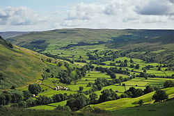
Dentdale is one of the few Yorkshire Dales that drain westwards to the Irish Sea. [3]

History

Dentdale was first settled in the 10th century when Norse invaders first entered the dale. [4] The dale was also known to the Romans although there is no evidence of settlement during that period. The dale was one of the last of the Yorkshire Dales to be Enclosed in 1859. [5]

The typical occupations in the dale were farming and worsted related. Several mills used the fast flowing waters of the River Dee to supply power to the mills. [6] At least one of these was converted to the Dent Marble industry by 1810. [7] Whilst fishing on the Dee at Dentdale in the 1840s, William Armstrong saw a waterwheel in action, supplying power to a marble quarry. It struck Armstrong that much of the available power was being wasted and it inspired him to design a successful hydraulic engine which began the accumulation of his wealth and industrial empire. [8] [9]

Dentdale was originally in the Ewecross wapentake of the West Riding of Yorkshire, but was transferred to Cumbria in 1974. [10]

Settlements

Dent village is the main shopping and social centre of the dale. There are two other major villages; Dent Head and Gawthrop. [11] Additionally there are two hamlets at the top of the dale - Cowgill (where Dent Station is located) and Stone House. [12] It has been noted that it is increasingly difficult for young people and family groups to stay in the dale as housing becomes more unaffordable. [13]

There are over 200 listed buildings and structures in Dentdale which include the railway viaducts, bridges, barns, farmhouse, mileposts and even telephone boxes. [14] Only one structure is Grade I listed, that of the Church of St Andrew in Dent. [15]

Transport

A steam train on the Arten Gill viaduct above Stonehouse Stonehouse Artengill Viaduct.jpg
A steam train on the Arten Gill viaduct above Stonehouse

The famous Settle-Carlisle Line [16] passes across the eastern edge of the dale being carried over the becks that feed the River Dee on Dent Head Viaduct [17] and over Artengill Beck on Arten Gill Viaduct. [18] [note 1]

The walking route of the Dales Way crosses through the dale in a rough east/west axis. [19] The route and the seclusion of the dale make it popular with walkers and lovers of The Dales. [20]

National Cycle route 68 (also known as the Pennine Cycleway) that runs from Derbyshire to Berwick-upon-Tweed passes through the dale. [21]

The C5101 road runs through the dale from the nearest main road at Sedbergh (the A683 and A684) to Newby Head Moss, east of the dale head, where it meets the B6255 Hawes to Ingleton road.

Western Dales Bus operate a year round Saturday and summer Sunday service between Dent station and Sedbergh with stops en route. [22]

Geology

The Dent Fault cuts across the valley close to the village of Gawthrop, marking a geological boundary between the Carboniferous Limestone of Deepdale and the Craven Dales to the south and the older Silurian and Ordovician rocks of the Howgill Fells to the north. [23]

The Upper Dentdale Cave System, which is 2 miles (3.2 km) east of Dent, was recognized as a site of Special Scientific Interest (SSSI) in 1998. [24] The cave system extends for 1 mile (1.6 km) beneath the valley floor under the River Dee and is notable for providing a unique insight into how caves are formed in valley floors. [25]

Dent Marble was quarried and polished in Dentdale between 1760 and 1909. [26] Both the viaducts that carry the Settle-Carlisle line over the dale are constructed from Dent Marble. [27] The opening of the railway afforded the opportunity to export the marble out of the dale for the first time. The stone is not actually marble, it is a highly polished form of Black Limestone. [28]

Notes

  1. Arten Gill Viaduct is the spelling from the railway even though the water below is Artengill.

Related Research Articles

<span class="mw-page-title-main">Yorkshire Dales</span> Upland area of the Pennines in Northern England

The Yorkshire Dales are an upland area of the Pennines in England. Most of the area is in the county of North Yorkshire, but it extends into Cumbria and a small part of Lancashire. It was historically entirely within Yorkshire. The majority of the Dales are part of the Yorkshire Dales National Park, created in 1954. The exception is the area around Nidderdale, which forms the separate Nidderdale Area of Outstanding Natural Beauty.

<span class="mw-page-title-main">Settle–Carlisle line</span> Railway line in northern England

The Settle–Carlisle line is a 73-mile-long (117 km) main railway line in northern England. The route, which crosses the remote, scenic regions of the Yorkshire Dales and the North Pennines, runs between Settle Junction, on the Leeds–Morecambe line, and Carlisle, near the English-Scottish borders. The historic line was constructed in the 1870s and has several notable tunnels and viaducts such as the imposing Ribblehead.

<span class="mw-page-title-main">Yorkshire Dales National Park</span> National park in England

The Yorkshire Dales National Park is a 2,178 km2 (841 sq mi) national park in England covering most of the Yorkshire Dales, with the notable exception of Nidderdale. Most of the park is in North Yorkshire, with a sizeable area in Cumbria and a small part in Lancashire. The park was designated in 1954, and extended in 2016. Over 95% of the land in the Park is under private ownership; there are over 1,000 farms in this area.

<span class="mw-page-title-main">Whernside</span> Mountain in the Yorkshire Dales, England

Whernside is a mountain in the Yorkshire Dales in Northern England. It is the highest of the Yorkshire Three Peaks, the other two being Ingleborough and Pen-y-ghent. It is the highest point in the ceremonial county of North Yorkshire and the historic West Riding of Yorkshire with the summit lying on the county boundary with Cumbria. It is the fifteenth most prominent hill in England.

<span class="mw-page-title-main">Dales Way</span> British hiking trail

The Dales Way is an 78.5-mile (126.3 km) long-distance footpath in Northern England, from Ilkley, West Yorkshire, to Bowness-on-Windermere, Cumbria. This walk was initially devised by the West Riding Ramblers' Association with the 'leading lights' being Colin Speakman and Tom Wilcock. The route was announced to the public in 1968 and the first recorded crossing was by a group of Bradford Grammar School Venture Scouts in 1969.

<span class="mw-page-title-main">Dent, Cumbria</span> Village and civil parish in Cumbria, England

Dent is a village and civil parish in Cumbria, England, within the historic boundaries of the West Riding of Yorkshire. It lies in Dentdale, a narrow valley on the western slopes of the Pennines within the Yorkshire Dales National Park, 4 miles (6 km) south east of Sedbergh and 8 miles (13 km) north east of Kirkby Lonsdale. At the 2011 census, Dent and Middleton had a total population of 785.

<span class="mw-page-title-main">Dent railway station</span> Railway station in Cumbria, England

Dent is a railway station on the Settle and Carlisle Line, which runs between Carlisle and Leeds via Settle. The station, situated 58 miles 29 chains (93.9 km) north-west of Leeds, serves the villages of Cowgill and Dent, South Lakeland in Cumbria, England. It is owned by Network Rail and managed by Northern Trains. It is the highest operational main line station in England.

<span class="mw-page-title-main">Garsdale Head</span> Landform watershed in Northern England

Garsdale Head is a hamlet mainly within the South Lakeland district of Cumbria, England. Historically part of the West Riding of Yorkshire, the hamlet is now on the border with Richmondshire, North Yorkshire. It lies within the boundaries of the Yorkshire Dales National Park.

<span class="mw-page-title-main">Great Knoutberry Hill</span> Mountain in the Yorkshire Dales, England

Great Knoutberry Hill, also commonly known as Widdale Fell, is a mountain located near Dent at the heads of Ribblesdale, Dentdale and Wensleydale, in the Yorkshire Dales National Park and within the boundaries of the historic county of Yorkshire. In fact, the borders between the West Riding and North Riding of Yorkshire meet at the summit, and the border between the modern administrative counties of Cumbria and North Yorkshire also runs over the fell. At a height of 2,205 feet (672 m) above sea level it is the 16th-highest fell in the Yorkshire Dales, with Rogan's Seat being exactly the same height.

<span class="mw-page-title-main">Crag Hill (Yorkshire Dales)</span>

Crag Hill is on the western edge of the Yorkshire Dales in northern England, not to be confused with the higher Crag Hill elsewhere in the county of Cumbria. It lies on the boundary of the Yorkshire Dales national park, but its summit is in South Lakeland district, Cumbria. It is part of a ridge including the neighbouring fells of Great Coum and Gragareth. The summit of Crag Hill is about 0.62 miles (1 km) away from the top of Great Coum, the latter being the highest point on the ridge at 2,254 feet (687 m).

<span class="mw-page-title-main">River Dee, Cumbria</span> River in Cumbria, England

The River Dee is a river running through the extreme south east of Cumbria, a part of the Craven region traditionally part of the West Riding of Yorkshire. Its name possibly derives from Brythonic deva meaning goddess, or from Dent or Dentdale, through which the river flows.

<span class="mw-page-title-main">Garsdale</span> Village and civil parish in Cumbria, England

Garsdale is a dale or valley in the south east of Cumbria, England, historically a part of the West Riding of Yorkshire. It is now within the South Lakeland local government district, but is still a "Yorkshire Dale" for planning purposes. In the 2001 census the parish had a population of 202, decreasing at the 2011 census to 191.

<span class="mw-page-title-main">Stone House, Cumbria</span> Human settlement in England

Stone House is a locality at Dent Head on the River Dee, in the county of Cumbria, England, to the south-east of Cowgill and to the north-west of Newby Head.

<span class="mw-page-title-main">Dales High Way</span>

A Dales High Way is a long-distance footpath in northern England. It is 90 miles (140 km) long and runs from Saltaire in West Yorkshire to Appleby-in-Westmorland, Cumbria, roughly parallel to the line of the Settle and Carlisle Railway.

<span class="mw-page-title-main">Widdale</span> Small valley in the Yorkshire Dales, England

Widdale is a small side dale on the south side of Wensleydale in North Yorkshire, England. The dale lies to the east of Great Knoutberry Hill and is bounded on the west by Dentdale, south by Sleddale and north by Mossdale. It is drained by Widdale and Snaizeholme Becks which feed the waters north into the River Ure at Appersett. The name Widdale means 'The Wooded Valley' in Old Norse.

<span class="mw-page-title-main">Dent Marble</span> Polished limestone from Northern England

Dent Marble is a highly polished form of limestone which occurs in the Dentdale district of Cumbria in England. The stone is noted for the presence of fossils which gives it its distinctive look. The stone is actually a crinoidal limestone and is not a true marble, but is known as a marble because it polished quite well. Dent Marble has been used for staircases, floors and hearths in railway stations and large buildings in England, Australia and Russia. The trade died out when import tariffs on Italian marble were relaxed, and Dent Marble became less popular.

<span class="mw-page-title-main">Arten Gill Viaduct</span> Railway viaduct in Cumbria, England

Arten Gill Viaduct is an eleven-arch railway bridge in Dentdale, Cumbria, England. The viaduct carries the Settle to Carlisle railway line over Artengill Beck. The viaduct was originally designed to be further west, which is lower down the steep valley side, but by moving the line slightly eastwards, the viaduct could be installed at a higher location, thereby using fewer materials in its height. Arten Gill Viaduct is constructed partly from Dent Marble in the inside of the arches instead of the more usual brick. Dent Marble is a type of dark limestone which was quarried from Artengill beneath the viaduct itself. The viaduct is a grade II listed structure, and a scheduled monument.

<span class="mw-page-title-main">Dandry Mire Viaduct</span> A railway viaduct in Cumbria, England

Dandry Mire Viaduct,, is a railway viaduct on the Settle & Carlisle line in Cumbria, England. It is just north of Garsdale station, 21 miles (34 km) from Settle, and 51 miles (82 km) south of Carlisle. When the Settle & Carlisle line was being built, the traversing of Dandry Mire was to have been by use of an embankment, but the bog swallowed all of the material poured into it, so a trench was dug instead, and a viaduct constructed. The viaduct, which is 227 yards (208 m) long and 50 feet (15 m) high, is still open to traffic on the railway, and is a prominent landmark at the head of Garsdale.

<span class="mw-page-title-main">Dent Head Viaduct</span> A railway viaduct in Cumbria, England

Dent Head Viaduct is a railway viaduct on the Settle–Carlisle line in Dentdale, Cumbria, England. It is the second major viaduct on the line northwards after Ribblehead Viaduct, and is just north of Blea Moor Tunnel at milepost 251, and to the south of Arten Gill Viaduct. Construction of the viaduct began in 1869, and it was completed in 1875, extra time being needed due to periods of heavy rainfall. The line bows slightly to the east in order to follow the contours of Woldfell, which it navigates on the western side. The viaduct was grade II Listed in 1999. Dent Head Viaduct is 17 miles (27 km) north of Settle Junction, and 57 miles (92 km) south of Carlisle railway station.

<span class="mw-page-title-main">Coal Road</span> Ancient road in Cumbria, England

The Coal Road is an unclassified highway which connects the railway stations at Garsdale and Dent in Cumbria, England. The road is within the Yorkshire Dales National Park, and was historically part of the West Riding of Yorkshire. The name derives from its use transporting locally mined coal, although before that it was used as a droving route between England and Scotland through Mallerstang.

References

  1. "Yorkshire Dales Walk - Dentdale". Yorkshire Life. Retrieved 5 January 2016.
  2. "Dent Head". www.yorkshire-dales.com. Retrieved 5 January 2016.
  3. "The Cumbrian Dales" (PDF). Yorkshire Dales. p. 1. Retrieved 5 January 2016.
  4. "Dentdale - Visit Cumbria". Visit Cumbria. Retrieved 5 January 2016.
  5. "Dent and Dentdale". Yorkshire Dales trail. Retrieved 5 January 2016.
  6. "Cowgill, a Geologist and the River Dee-Walks-The AA". www.theaa.com. Retrieved 5 January 2016.
  7. "Out of Oblivion: A landscape through time". www.outofoblivion.org.uk. Retrieved 5 January 2016.
  8. Lennie, Stuart (2005). The roof of Wensleydale : a portrait of Wensleydale's two thousand foot fells. Kirkby Stephen: Hayloft. p. 81. ISBN   1-904524-30-3.
  9. Linsley, Stafford M. "Armstrong, William George, Baron Armstrong". Oxford Dictionary of National Biography (online ed.). Oxford University Press. doi:10.1093/ref:odnb/669.(Subscription or UK public library membership required.)
  10. "Dent Cumbria County History Trust". www.cumbriacountyhistory.org.uk. Retrieved 5 January 2016.
  11. "Dentdale". www.yorkshire-dales.com. Retrieved 5 January 2016.
  12. "Dentdale". Yorkshire Dales National Park Authority. Retrieved 5 January 2016.
  13. "DENT CONSERVATION AREA APPRAISAL" (PDF). Yorkshire Dales. December 2009. p. 21. Retrieved 5 January 2016.
  14. "Listed Buildings in Dent, Cumbria, England". www.britishlistedbuildings.co.uk. Retrieved 5 January 2016.
  15. "Church of St Andrew - Dent - Cumbria - England". www.britishlistedbuildings.co.uk. Retrieved 5 January 2016.
  16. "The Settle - Carlisle Line". www.sandctrust.org.uk. Retrieved 5 January 2016.
  17. Greenbank, Tony (9 May 2011). "Country diary: Dentdale, Yorkshire Dales". The Guardian. Retrieved 5 January 2016.
  18. "Heritage Locations". www.transportheritage.com. Retrieved 5 January 2016.
  19. "The Route". www.dalesway.org. Retrieved 5 January 2016.
  20. "DENT, DEEPDALE & THE DEE WALK seclusion of Dentdale". On: Yorkshire Magazine. Retrieved 5 January 2016.
  21. "Yorkshire Dales National Park - All routes". www.cyclethedales.org.uk. Retrieved 5 January 2016.
  22. "Dentdale and Howgills". www.walkingintheyorkshiredales.co.uk. Retrieved 5 January 2016.
  23. "Dentdale". www.yorkshiredales.co.uk. Archived from the original on 4 March 2016. Retrieved 5 January 2016.
  24. "Recognition for caves". The Westmorland Gazette. Retrieved 5 January 2016.
  25. "Upper Dentdale Cave" (PDF). sssi - natural england. pp. 1–2. Retrieved 5 January 2016.
  26. "The Dentdale Marble Industry". www.cumbria-industries.org.uk. 20 April 2014. Retrieved 5 January 2016.
  27. "Engineering Timelines - Arten Gill Viaduct". www.engineering-timelines.com. Retrieved 5 January 2016.
  28. "History of Yorkshire". www.museumsintheyorkshiredales.co.uk. Retrieved 5 January 2016.

54°16′41″N2°27′14″W / 54.278°N 2.454°W / 54.278; -2.454