
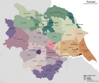
The West Riding of Yorkshire is one of three historic subdivisions of Yorkshire, England. From 1889 to 1974 the riding was an administrative county named County of York, West Riding. The lieutenancy at that time included the city of York and as such was named "West Riding of the County of York and the County of the City of York". The riding ceased to be used for administrative purposes in 1974, when England's local government was reformed.
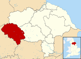
Craven was a non-metropolitan district in the west of North Yorkshire, centred on the market town of Skipton. The name Craven is much older than the modern district and encompassed a larger area. This history is also reflected in the way the term is still commonly used, such as by the Church of England.
The Bishop of Ripon is an episcopal title which takes its name after the city of Ripon in North Yorkshire, England. The bishop is one of the area bishops of the Diocese of Leeds in the Province of York. The area bishop of Ripon has oversight of the archdeaconry of Richmond and Craven, which consists of the deaneries of Bowland, Ewecross, Harrogate, Richmond, Ripon, Skipton, and Wensley.
Horton in Ribblesdale is a small village and civil parish in Ribblesdale in the former Craven district of North Yorkshire, England. It is situated on the Settle–Carlisle Railway to the west of Pen-y-ghent.
The Ainsty or the Ainsty of York was a historic district of Yorkshire, England, west of the city of York. Originally a wapentake or subdivision of the West Riding of Yorkshire it later had a unique status as a rural area controlled by the corporation of the city.

Staincross was a Wapentake, which is an administrative division, in the historic county of the West Riding of Yorkshire. It consisted of seven parishes, and included the towns of Barnsley and Penistone
Staincliffe, also known as Staincliff, was a wapentake of the West Riding of Yorkshire, England.

South Milford is a village and civil parish in the county of North Yorkshire, England. The civil parish includes the hamlet of Lumby, located south-west of the main village.
Long Preston is a village and civil parish in the Craven district of North Yorkshire, England, in the Yorkshire Dales. It lies along the A65 road, and is 12 miles (19 km) from Skipton and 4 miles (6 km) from Settle. The population of Long Preston in 2001 was 680, increasing to 742 at the 2011 Census.
Northern West Riding of Yorkshire was a parliamentary constituency covering part of the historic West Riding of Yorkshire. It returned two Members of Parliament (MPs) to the House of Commons of the Parliament of the United Kingdom, elected by the bloc vote system.

Gisburn is a village and civil parish within the Ribble Valley borough of Lancashire, England. Historically within the West Riding of Yorkshire, it lies 8 miles (13 km) northeast of Clitheroe and 11 miles (18 km) west of Skipton. The civil parish had a population of 506, recorded in the 2001 census, increasing to 521 at the 2011 Census.

Sawley is a village and civil parish in the Borough of Ribble Valley in Lancashire, England. The population of the civil parish was 305 at the 2001 Census, rising to 345 at the 2011 census. It is situated north-east of Clitheroe, on the River Ribble. It was historically part of the West Riding of Yorkshire.
East Hardwick is a village and civil parish in the City of Wakefield in West Yorkshire, England. It has a population of 191, reducing to 173 at the 2011 Census. Until 1974 it was part of Osgoldcross Rural District.

Gisburn Forest is a civil parish in the Ribble Valley, in Lancashire, England. Mainly lying within the Forest of Bowland Area of Outstanding Natural Beauty, the parish includes the larger part of the village of Tosside and the hamlet of Grunsagill to the south. Historically, the parish lay within the West Riding of Yorkshire. It had a population of 151 at the 2011 Census.

The Anglican Diocese of Leeds is a diocese of the Church of England, in the Province of York. It is the largest diocese in England by area, comprising much of western Yorkshire: almost the whole of West Yorkshire, the western part of North Yorkshire, the town of Barnsley in South Yorkshire, and most of the parts of County Durham, Cumbria and Lancashire which lie within the historic boundaries of Yorkshire. It includes the cities of Leeds, Bradford, Wakefield and Ripon. It was created on 20 April 2014 following a review of the dioceses in Yorkshire and the dissolution of the dioceses of Bradford, Ripon and Leeds, and Wakefield.
Hang East was a Wapentake (Hundred), which is an administrative division, in the historic county of the North Riding of Yorkshire. It was one of the smaller wapentakes by area and consisted of nine parishes and two towns; Bedale and Masham.
Hallikeld was a wapentake, an administrative division analogous to a hundred, in the historic county of the North Riding of Yorkshire. It was one of the smaller wapentakes by area and consisted of seven parishes.

Marton cum Grafton is a civil parish in the Borough of Harrogate of North Yorkshire, England. The parish has only two settlements, and has a magnesian limestone and sandstone geography, which has been used for quarrying. The landform is broadly flat, though there are some small hills with the Marton and Grafton being separated by 98 feet (30 m) despite being only 0.5 miles (0.8 km) apart.
Pickering Lythe was one of twelve wapentakes within the historical county of the North Riding of Yorkshire, England. It was recognised within the Domesday Book as Dic, an area covering the Vale of Pickering, and swathes of land east towards the North Yorkshire coast.

Eldroth is a village in North Yorkshire, England. It is in the civil parish of Lawkland, part of the former Craven District, some 3.25 miles (5.23 km) west of Settle, on a stream which is one of the tributaries of the River Wenning. The main part of Eldroth only consists of twelve buildings, but the presence of the church, marks the settlement out as a village, rather than a hamlet. Eldroth lies just within the Forest of Bowland Area of Outstanding Natural Beauty.
