
The Yorkshire Dales are a series of valleys, or dales, in the Pennines, an upland range in England. They are mostly located in the ceremonial county of North Yorkshire, but extend into Cumbria and Lancashire; they were historically entirely within Yorkshire. The majority of the dales are within the Yorkshire Dales National Park, created in 1954. The exception is the area around Nidderdale, which forms the separate Nidderdale Area of Outstanding Natural Beauty.
The mountains of Whernside, Ingleborough and Pen-y-ghent are collectively known as the Three Peaks. The peaks, which form part of the Pennine range, encircle the head of the valley of the River Ribble in the Yorkshire Dales National Park in the North of England.
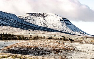
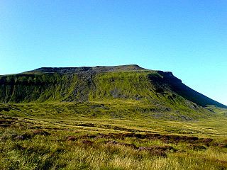
Ingleborough is the second-highest mountain in the Yorkshire Dales, England. It is one of the Yorkshire Three Peaks, and is frequently climbed as part of the Three Peaks walk. A large part of Ingleborough is designated as a Site of Special Scientific Interest and National Nature Reserve and is the home of a new joint project, Wild Ingleborough, with aims to improve the landscape for wildlife and people.

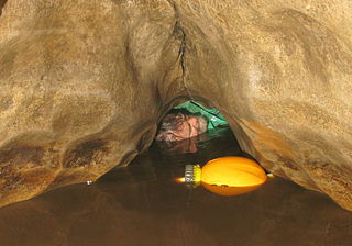
Gaping Gill is a natural cave in North Yorkshire, England. It is one of the unmistakable landmarks on the southern slopes of Ingleborough – a 98-metre (322 ft) deep pothole with the stream Fell Beck flowing into it. After falling through one of the largest known underground chambers in Britain, the water disappears into the bouldery floor and eventually resurges adjacent to Ingleborough Cave.

Cautley Spout is England's highest (cascade) waterfall above ground.. The broken cascade of falls tumbles a total of 650 feet down a cliff face at the head of a wild and bleak glacial valley that comes down from a high plateau called The Calf. It is located in the Howgill Fells, traditionally in the West Riding of Yorkshire but now in the administrative county of Cumbria on the western edge of the Yorkshire Dales National Park. The waterfall is just north of Sedbergh. This fall is one of the few cascade falls in England; most are either tiered or plunge falls.

Ingleton is a village and civil parish in North Yorkshire, England. The village is 17 miles (27 km) from Kendal and 17 miles (27 km) from Lancaster on the western side of the Pennines. It is 9 miles (14 km) from Settle. The River Doe and the River Twiss meet to form the source of the River Greta, a tributary of the River Lune. The village is on the A65 road and at the head of the A687. The B6255 takes the south bank of the River Doe to Ribblehead and Hawes. All that remains of the railway in the village is the landmark Ingleton Viaduct. Arthur Conan Doyle was a regular visitor to the area and was married locally, as his mother lived at Masongill from 1882 to 1917. It has been claimed that there is evidence that the inspiration for the name Sherlock Holmes came from here.
Reginald John Farrer, was a traveller and plant collector. He published a number of books, although is best known for My Rock Garden. He travelled to Asia in search of a variety of plants, many of which he brought back to England and planted near his home village of Clapham, North Yorkshire.

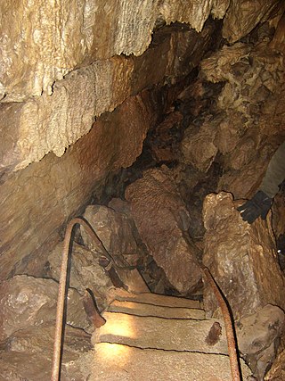
Ingleborough Cave is a show cave close to the village of Clapham in North Yorkshire, England, adjacent to where the water from Gaping Gill resurges.

Fell Beck is a stream near the foot of Ingleborough, in the Yorkshire Dales National Park. It is notable for running into Gaping Gill, the second-largest natural cave shaft in the UK. As it falls down the shaft for 110 metres it is the tallest unbroken waterfall in the UK. At times it is blocked off by a temporary dam to allow members of the public to descend the Gaping Gill shaft on a winch.

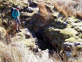
Bar Pot is one of the entrances to the Gaping Gill cave system being located about 340 metres (370 yd) south of Gaping Gill Main Shaft, on Ingleborough in the Yorkshire Dales. It is a popular entrance into the system, being one of the easiest, driest, and having just two vertical pitches to contend with. It lies within the designated Ingleborough Site of Special Scientific Interest.
Disappointment Pot is one of the entrances to the Gaping Gill cave system, located in a steep grassy shakehole some 120 metres (130 yd) south-east of Gaping Gill Main Shaft. Its mainly narrow stream passage descends a number of small shafts to enter the main system as a major inlet of Hensler's Master Cave. It lies within the designated Ingleborough Site of Special Scientific Interest.
Stream Passage Pot is one of the entrances to the Gaping Gill system being located about 320 metres (350 yd) ESE of Gaping Gill Main Shaft. It is a popular and sporting entrance into the system, featuring three well-watered big shafts. It is the highest entrance of the Gaping Gill system, so the full depth of the system, 198 metres (650 ft), is measured from its entrance. It lies within the designated Ingleborough Site of Special Scientific Interest.
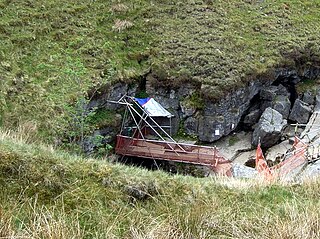
Flood Entrance Pot is one of the entrances to the Gaping Gill cave system located about 300 metres (330 yd) south of Gaping Gill Main Shaft. It was the first alternative entrance into the main system to be explored, and it is now a popular entrance into the system, with a fine 38-metre (125 ft) pitch landing in Gaping Gill's South-East Passage. It lies within the designated Ingleborough Site of Special Scientific Interest.

Rat Hole is one of the entrances to the Gaping Gill cave system, located in the north bank of Fell Beck 30 metres (33 yd) upstream of Gaping Gill Main Shaft. A small, awkward, tube-like passage descends into a stream passage, and hence to a 100-metre (330 ft) shaft into Gaping Gill Main Chamber. The sharp and loose nature of the rock, and the quantity of water prevented full exploration for over 80 years, but the current route is described in one guide book as "a technical and exhilarating adventure". It lies within the designated Ingleborough Site of Special Scientific Interest.
Jib Tunnel, also known as Lateral Passage is one of the entrances into the Gaping Gill cave system, located behind a large boulder in the north bank of Fell Beck adjacent to Gaping Gill Main Shaft. Although short, it leads to Lateral Shaft, a direct descent into Gaping Gill Main Chamber which is a popular caving route, and has had considerable significance in the history of the exploration of Gaping Gill. It lies within the designated Ingleborough Site of Special Scientific Interest.
Skirwith Cave is a major resurgence solutional cave on Ingleborough in Chapel-le-Dale, North Yorkshire, England; it was a show cave between 1964 and 1974. It is no longer open to the public but is still visited by cavers. It lies within the designated Ingleborough Site of Special Scientific Interest.

Weathercote Cave is a natural solutional cave in Chapel-le-Dale, North Yorkshire, England. It has been renowned as a natural curiosity since the eighteenth century, and was accessible to paying visitors until 1971. The entrance is a large shaft about 20 metres (66 ft) deep, dominated by a waterfall entering at one end. It lies within the designated Ingleborough Site of Special Scientific Interest.

Crummackdale,, is a small valley north of the village of Austwick in the Craven District of North Yorkshire, England. The Valley is drained by Austwick Beck, which flows into the River Wenning, which in turn heads westwards to empty into the Irish Sea. Crummackdale is a narrow south west facing dale, at the south west corner of the Yorkshire Dales National Park.

The Long Kin East Cave - Rift Pot system is a limestone cave system on the southern flanks of Ingleborough, North Yorkshire in England lying within the designated Ingleborough Site of Special Scientific Interest. Long Kin East Cave starts as a long meandering stream passage but then plummets down a 58-metre (190 ft) deep shaft when it meets a shattered fault into which Rift Pot also descends. At the bottom, the stream flows through some low canals and sumps, to eventually emerge at Austwick Beck Head in Crummackdale.

Chapel-le-Dale is west-facing valley in the Yorkshire Dales, England. The U-shaped valley of Chapel-le-Dale is one of the few which drain westwards towards the Irish Sea, however, the river that flows through the valley has several names with the Environment Agency and the Ordnance Survey listing it as the River Doe. However, some older texts insist the name of the watercourse through the dale is the River Greta, which runs from a point below the hamlet of Chapel-le-Dale, and onwards past Ingleton. The dale is sparsely populated with only one settlement, the hamlet of Chapel-le-Dale, which has a small chapel.


