
The Yorkshire Dales are a series of valleys, or dales, in the Pennines, an upland range in England. They are mostly located in the ceremonial county of North Yorkshire, but extend into Cumbria and Lancashire; they were historically entirely within Yorkshire. The majority of the dales are within the Yorkshire Dales National Park, created in 1954. The exception is the area around Nidderdale, which forms the separate Nidderdale Area of Outstanding Natural Beauty.

Wensleydale is a valley in North Yorkshire, England. It is one of the Yorkshire Dales, which are part of the Pennines. The dale is named after the village of Wensley, formerly the valley's market town. The principal river of the valley is the Ure, which is the source of the alternative name Yoredale. The majority of the dale is within the Yorkshire Dales National Park; the part below East Witton is within the national landscape of Nidderdale.

Malham Beck is a stream some 1.2 miles (2 km) long, running southwards through the valley beneath Malham Cove in the Yorkshire Dales, England. It originates in a cave beneath Malham Cove, and flows through Malham before joining Gordale Beck to become the River Aire just south of the village.
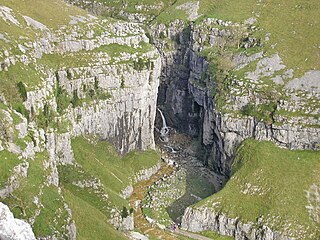
Gordale Scar is a limestone ravine 1 mile (1.6 km) north-east of Malham, North Yorkshire, England. It contains two waterfalls and has overhanging limestone cliffs over 330 feet (100 m) high. The gorge could have been formed by water from melting glaciers or a cavern collapse. The stream flowing through the scar is Gordale Beck, which on leaving the gorge flows over Janet's Foss before joining Malham Beck 2 miles (3 km) downstream to form the River Aire. A right of way leads up the gorge, but requires climbing approximately 10 feet (3 m) of tufa at the lower waterfall.

Fryup is a hamlet in the North York Moors National Park in North Yorkshire, England. It is within the civil parish of Danby, and is located alongside Great Fryup Beck in Great Fryup Dale.
Nidderdale was a rural district in the West Riding of Yorkshire from 1938 to 1974. It was created from the combination of most of the disbanded rural districts of Great Ouseburn and Knaresborough.

East Gill Force is a waterfall in Swaledale, 330 yards (300 m) east of the hamlet of Keld, in the Yorkshire Dales National Park, North Yorkshire, England. The falls are located on East Gill at grid reference NY896012, just before its confluence with the River Swale at the point where the Pennine Way and the Coast to Coast Walk intersect. The falls are a popular spot for visitors, not just long-distance walkers but also families and picnickers because of the proximity of the road. East Gill Force has two main torrents: the upper falls have an impressive 15-foot (4.5 m) drop whilst the lower section is a series of stepped cascades that fall 9.8 feet (3 m) as East Gill enters the River Swale.
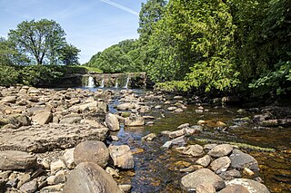
Wain Wath Force is a waterfall on the River Swale in the Yorkshire Dales National Park, North Yorkshire, England. The falls are at grid reference NY883015, 0.6 miles (1 km) upstream from the hamlet of Keld which has three other waterfalls in its vicinity. The names of waterfalls in the north of England often contain "force" after the Old Norse word foss, which means "waterfall".
The River Wenning is a tributary of the River Lune, flowing through North Yorkshire and Lancashire. The name derives from the Old English Wann, meaning dark river.

Ribblesdale is one of the Yorkshire Dales in England. It is the dale or upper valley of the River Ribble in North Yorkshire. Towns and villages in Ribblesdale include Selside, Horton-in-Ribblesdale, Stainforth, Langcliffe, Giggleswick, Settle, Long Preston and Hellifield. Below Hellifield the valley of the river is generally known as the Ribble Valley.

Bransdale is a valley running south through North Yorkshire, England, and part of the North York Moors National Park. Sandwiched between Bilsdale to the west and Farndale to the east, it is formed from the dales of Bransdale itself at the top of the valley, Sleightholmedale and Kirkdale. It carries a river called Hodge Beck en route from Cockayne to the River Dove from Farndale three miles (4.8 km) of Kirkbymoorside, which runs on into the Vale of Pickering and the River Rye.

Countersett is the largest of the three settlements in Raydale, around Semerwater in the Richmondshire district of North Yorkshire, England. It is in the Yorkshire Dales to the north of the lake. The Boar East and West were once one farm, and before that a pub called The Boar Inn. The date 1667 was above the door, along with a Latin inscription which translated as "Now mine, once thine, but whose afterwards I do not know"
Marsett is one of three settlements in around Semer Water in Raydale, a small side dale off Wensleydale in North Yorkshire, England. Marsett is only a hamlet and lies to the south-west of the lake, at a point where a smaller side dale, Bardale, joins Raydale.
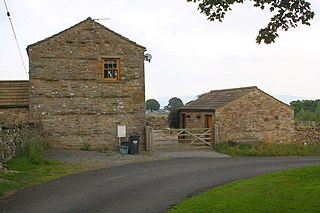
Newbiggin is a hamlet very close to Askrigg, North Yorkshire, England. Another Newbiggin is only about 7 miles (11 km) away. The hamlet consists of eight dwellings and other smaller buildings such as barns, just to the east of Askrigg at a height of 888 feet (270.6 m) above sea level.
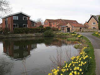
Ferrensby is a village and civil parish in the Harrogate district of North Yorkshire, England. The population of the civil parish at the 2011 census was 187. It is about 3 miles (4.8 km) north-east of Knaresborough and near the A1(M) motorway. Nearby attractions include a balloon centre and a maze.

Hesleden is a hamlet in Littondale in the Yorkshire Dales in England. It lies within the civil parish of Halton Gill in the Craven district of North Yorkshire. Nether Hesleden is 1.1 miles (1.8 km) west of Litton, and Upper Hesleden is a further 1.4 miles (2.3 km) west, on the road from Halton Gill to Stainforth.
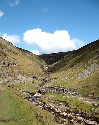
Gunnerside Gill is a small valley in the Yorkshire Dales, England, which branches off Swaledale into moorland to the north of Gunnerside.

Arkle Beck is the stream running through the valley of Arkengarthdale in the Yorkshire Dales, England. It is a tributary of the River Swale, which it joins just past Reeth at Grinton Bridge. The beck itself has several tributaries which include:

Stonebeck Down is a civil parish in Harrogate district, North Yorkshire, England. The main settlements in the parish are the village of Ramsgill and the hamlets of Stean and Heathfield. The population of the parish in the 2011 census was 192.

Ling Gill is a gill in the Yorkshire Dales in North Yorkshire, England. Cam Beck, a tributary of the River Ribble, flows through the gill.

