
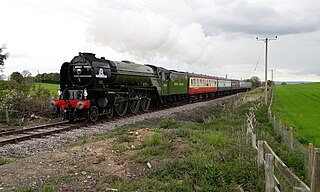
The Settle–Carlisle line is a 73-mile-long (117 km) main railway line in northern England. The route, which crosses the remote, scenic regions of the Yorkshire Dales and the North Pennines, runs between Settle Junction, on the Leeds–Morecambe line, and Carlisle, near the English-Scottish borders. The historic line was constructed in the 1870s and has several notable tunnels and viaducts such as the imposing Ribblehead.
The Wensleydale Railway is a heritage railway in Wensleydale and Lower Swaledale in North Yorkshire, England. It was built in stages by different railway companies and originally extended to Garsdale railway station on the Settle-Carlisle line. Since 2003, the remaining line has been run as a heritage railway. The line runs 22 miles (35 km) between Northallerton West station, about a fifteen-minute walk from Northallerton station on the East Coast Main Line, and Redmire.

Hawes is a market town and civil parish in North Yorkshire, England, at the head of Wensleydale in the Yorkshire Dales, and historically in the North Riding of Yorkshire. The River Ure north of the town is a tourist attraction in the Yorkshire Dales National Park.
Sedbergh is a town and civil parish in the ceremonial county of Cumbria. It falls within the historic boundaries of the West Riding of Yorkshire. Since April 2023, it has been administered by Westmorland and Furness local authority. The 2001 census gave the parish a population of 2,705, increasing at the 2011 census to 2,765. It lies about 10 miles (16 km) east of Kendal, 28 miles (45 km) north of Lancaster and about 10 miles (16 km) north of Kirkby Lonsdale, within the Yorkshire Dales National Park. It stands at the foot of Howgill Fells, on the north bank of the River Rawthey, which joins the River Lune 2 miles (3 km) below the town.

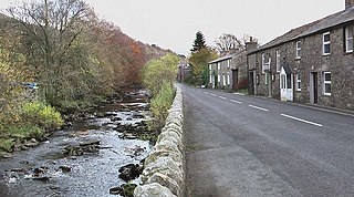
Dent is a village and civil parish in Cumbria, England, within the historic boundaries of the West Riding of Yorkshire. It lies in Dentdale, a narrow valley on the western slopes of the Pennines within the Yorkshire Dales National Park, 4 miles (6 km) south east of Sedbergh and 8 miles (13 km) north east of Kirkby Lonsdale. At the 2011 census, Dent and Middleton had a total population of 785.

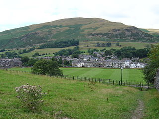
Askrigg is a small village and civil parish in Wensleydale in the Yorkshire Dales National Park. It was formerly a part of the Richmondshire district of North Yorkshire, England. The village and its parish are located in Upper Wensleydale, 12 miles (19 km) west of Leyburn, and 5 miles (8 km) east of Hawes. It is 31.4 miles (50.5 km) west of the county town of Northallerton.

Aysgarth is a village and civil parish in Wensleydale, in North Yorkshire, England. The village is in the Yorkshire Dales National Park, about 16 miles (26 km) south-west of Richmond and 22.6 miles (36.4 km) west of the county town of Northallerton.

Garsdale is a railway station in Cumbria, England, on the Settle and Carlisle Line, which runs between Carlisle and Leeds via Settle. The station, situated 51 miles 29 chains (82.7 km) south-east of Carlisle, serves the village of Garsdale and town of Sedbergh in Cumbria, and the market town of Hawes in North Yorkshire. It is owned by Network Rail and managed by Northern Trains.

Appersett is a hamlet in the Yorkshire Dales in the Richmondshire district of North Yorkshire, England one mile (1.6 km) west of Hawes. It lies on the A684 road and an unclassified road runs alongside Widdale Beck to connect with the B6255 road between Hawes and Ingleton.

The A684 is an A road that runs through Cumbria and North Yorkshire, starting at Kendal, Cumbria and ending at Ellerbeck and the A19 road in North Yorkshire. It crosses the full width of the Yorkshire Dales, passing through Garsdale and the full length of Wensleydale.
Garsdale is a dale or valley in the south east of Cumbria, England, historically a part of the West Riding of Yorkshire. It is now within the Westmorland and Furness local government district, and in the Yorkshire Dales National Park for planning purposes. In the 2001 census the parish had a population of 202, decreasing at the 2011 census to 191.

Dentdale is a dale or valley in the north-west of the Yorkshire Dales National Park in Cumbria, England. It is the valley of the River Dee, but takes its name from the village of Dent. The dale runs east to west, starting at Dent Head, which is the location of a railway viaduct on the Settle-Carlisle Line.

The Ingleton branch line was a rural railway line in the West Riding of Yorkshire, Lancashire and Westmorland in England. It was originally planned in 1846 to form part of a main line route from London to Scotland, but fell victim to rivalry between railway companies. Completion was delayed until 1861, and it was only ever a rural branch line, serving the village of Ingleton and towns of Kirkby Lonsdale and Sedbergh. It closed to passengers in 1954 and was dismantled in 1967.
Garsdale is a civil parish in the South Lakeland District of Cumbria, England. It contains 62 listed buildings that are recorded in the National Heritage List for England. Of these, three are listed at Grade II*, the middle of the three grades, and the others are at Grade II, the lowest grade. The parish is in the Yorkshire Dales National Park, it contains the village of Garsdale and the hamlet of Garsdale Head, and is otherwise rural. The A684 road runs through the valley, and most of the listed buildings are situated along, or are close to this road. The Settle–Carlisle line of the former Midland Railway passes through the eastern part of the parish, and the listed buildings associated with this are a viaduct, a bridge and a station box. Most of the other listed buildings are farmhouses, farm buildings, and houses and associated structures. Also listed are other bridges, milestones, a church, chapels, and a boundary marker.

The Richmond to Lancaster Turnpike, was a road that was opened in the second half of the 18th century between Richmond, in the North Riding of Yorkshire and Lancaster in Lancashire, Northern England. The turnpike was built to allow goods to be taken from Yorkshire to the port of Lancaster. It was approved in 1751, but was not wholly completed until 1774.

Dent Marble is a highly polished form of limestone which occurs in the Dentdale district of Cumbria in England. The stone is noted for the presence of fossils which gives it its distinctive look. The stone is actually a crinoidal limestone and is not a true marble, but is known as a marble because it polished quite well. Dent Marble has been used for staircases, floors and hearths in railway stations and large buildings in England, Australia and Russia. The trade died out when import tariffs on Italian marble were relaxed, and Dent Marble became less popular.

Dandry Mire Viaduct,, is a railway viaduct on the Settle & Carlisle line in Cumbria, England. It is just north of Garsdale station, 21 miles (34 km) from Settle, and 51 miles (82 km) south of Carlisle. When the Settle & Carlisle line was being built, the traversing of Dandry Mire was to have been by use of an embankment, but the bog swallowed all of the material poured into it, so a trench was dug instead, and a viaduct constructed. The viaduct, which is 227 yards (208 m) long and 50 feet (15 m) high, is still open to traffic on the railway, and is a prominent landmark at the head of Garsdale.

The Moorcock Inn is a public house near the watershed between the rivers Clough and Ure, in Upper Wensleydale, North Yorkshire, England. It is adjacent to the junction of the A684 road and the B6259 road and near Garsdale railway station on the Settle–Carlisle line. The history of the inn can be traced back to the 1740s but it has been called The Moorcock only since 1840. The pub is near some long-distance paths and is popular with walkers.

Grisedale is a south east facing Dale in Cumbria, England, 8 miles (13 km) east of Sedbergh, and 7 miles (11 km) west of Hawes. Grisedale Beck, which drains Baugh Fell, flows down the dale eastwards, and on reaching the valley floor at Garsdale, forms the River Clough before turning westwards towards the Irish Sea. A small part of the north-eastern side of the dale is in North Yorkshire, however, until 1974, all of the area around, and including Grisedale, was part of the West Riding of Yorkshire. The dale was largely depopulated of its working farmers during the 20th century, however, some of the houses have been re-occupied by non-agricultural inhabitants.

Lunds is a hamlet in North Yorkshire, England, near to the watershed of the Eden and Ure rivers. It is on the border between Cumbria and North Yorkshire, and was at one time allocated to the West Riding, but has been traditionally treated as being in the North Riding, now North Yorkshire.


