The Yorkshire Dales is an upland area of the Pennines in the historic county of Yorkshire, England, most of it in the Yorkshire Dales National Park created in 1954.

Dent is a village and civil parish in Cumbria, England, within the historic boundaries of the West Riding of Yorkshire. It lies in Dentdale, a narrow valley on the western slopes of the Pennines within the Yorkshire Dales National Park, 4 miles (6 km) south east of Sedbergh and 8 miles (13 km) north east of Kirkby Lonsdale. At the 2011 census, Dent and Middleton had a total population of 785.

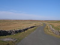
The Pennine Bridleway is a National Trail in Northern England.

Mallerstang is a civil parish in the extreme east of Cumbria, and, geographically, a dale at the head of the upper Eden Valley. Originally part of Westmorland, it lies about 6 miles (9.7 km) south of the nearest town, Kirkby Stephen. Its eastern edge, at Aisgill, borders on North Yorkshire; and since August 2016 it has been within the Yorkshire Dales National Park.
Garsdale Head is a hamlet mainly within the South Lakeland district of Cumbria, England. Historically part of the West Riding of Yorkshire, the hamlet is now on the border with Richmondshire, North Yorkshire. It lies within the boundaries of the Yorkshire Dales National Park.

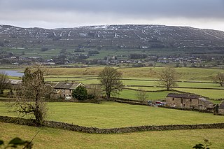
Great Knoutberry Hill, also commonly known as Widdale Fell, is a mountain located near Dent at the heads of Ribblesdale, Dentdale and Wensleydale, in the Yorkshire Dales National Park and within the boundaries of the historic county of Yorkshire. In fact, the borders between the West Riding and North Riding of Yorkshire meet at the summit, and the border between the modern administrative counties of Cumbria and North Yorkshire also runs over the fell. At a height of 2,205 feet (672 m) above sea level it is the 16th-highest fell in the Yorkshire Dales, with Rogan's Seat being exactly the same height.
Garsdale is a dale or valley in the south east of Cumbria, England, historically a part of the West Riding of Yorkshire. It is now within the South Lakeland local government district, but is still a "Yorkshire Dale" for planning purposes. In the 2001 census the parish had a population of 202, decreasing at the 2011 census to 191.

Baugh Fell is a large, flat-topped hill in the northern Pennines of England. It lies in the north-western corner of the Yorkshire Dales National Park, immediately to the east of the Howgill Fells and to the north of Whernside, the highest of the Yorkshire Three Peaks. Formerly in the West Riding of Yorkshire, since 1974 it has been part of the county of Cumbria.

Dentdale is a dale or valley in the north-west of the Yorkshire Dales National Park in Cumbria, England. It is the valley of the River Dee, but takes its name from the village of Dent. The dale runs east to west, starting at Dent Head, which is the location of a railway viaduct on the Settle-Carlisle Line.

A Dales High Way is a long-distance footpath in northern England. It is 90 miles (140 km) long and runs from Saltaire in West Yorkshire to Appleby-in-Westmorland, Cumbria, roughly parallel to the line of the Settle and Carlisle Railway.

Widdale is a small side dale on the south side of Wensleydale in North Yorkshire, England. The dale lies to the east of Great Knoutberry Hill and is bounded on the west by Dentdale, south by Sleddale and north by Mossdale. It is drained by Widdale and Snaizeholme Becks which feed the waters north into the River Ure at Appersett. The name Widdale means 'The Wooded Valley' in Old Norse.

Lady Anne's Way is a 100-mile (160 km) hiking route between Skipton and Penrith in Northern England. The trail is punctuated by houses and towers once owned by the Clifford family, but is named after Lady Anne Clifford who renovated and repaired the buildings in the 17th century. The route goes through Grassington, Buckden, Askrigg, Garsdale Head, Kirkby Stephen, Great Ormside, Appleby-in-Westmorland and Penrith.

Dent Marble is a highly polished form of limestone which occurs in the Dentdale district of Cumbria in England. The stone is noted for the presence of fossils which gives it its distinctive look. The stone is actually a crinoidal limestone and is not a true marble, but is known as a marble because it polished quite well. Dent Marble has been used for staircases, floors and hearths in railway stations and large buildings in England, Australia and Russia. The trade died out when import tariffs on Italian marble were relaxed, and Dent Marble became less popular.

Arten Gill Viaduct is an eleven-arch railway bridge in Dentdale, Cumbria, England. The viaduct carries the Settle to Carlisle railway line over Artengill Beck. The viaduct was originally designed to be further west, which is lower down the steep valley side, but by moving the line slightly eastwards, the viaduct could be installed at a higher location, thereby using fewer materials in its height. Arten Gill Viaduct is constructed partly from Dent Marble in the inside of the arches instead of the more usual brick. Dent Marble is a type of dark limestone which was quarried from Artengill beneath the viaduct itself. The viaduct is a grade II listed structure, and a scheduled monument.
Wether Fell, also known as Drumaldrace, is a mountain in the Yorkshire Dales National Park, in North Yorkshire, England. Wether Fell is mountain that divides Wensleydale in the north and Upper Wharfedale in the south. Its summit is 614 metres (2,014 ft). A Roman Road, the Cam High Road, passes along the southern edge of the summit reaching 1,900 feet (580 m).

The Moorcock Inn is a public house at the watershed of the Eden, Clough and Ure rivers, in Upper Wensleydale, North Yorkshire, England. It is adjacent to the A684 road where it has a junction with the B6259 road, and near to Garsdale railway station on the Settle–Carlisle line. The history of the inn can be traced back to the 1740s, but it has only been named The Moorcock since 1840. The pub is near to some long-distance paths, and is popular with walkers.

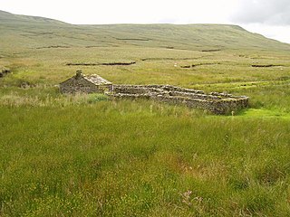
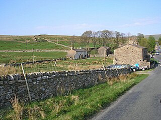
Grisedale is a south east facing Dale in Cumbria, England, 8 miles (13 km) east of Sedbergh, and 7 miles (11 km) west of Hawes. Grisedale Beck, which drains Baugh Fell, flows down the dale eastwards, and on reaching the valley floor at Garsdale, forms the River Clough before turning westwards towards the Irish Sea. A small part of the north-eastern side of the dale is in North Yorkshire, however, until 1974, all of the area around, and including Grisedale, was part of the West Riding of Yorkshire. The dale was largely depopulated of its working farmers during the 20th century, however, some of the houses have been re-occupied by non-agricultural inhabitants.

Lunds is a hamlet in North Yorkshire, England, near to the watershed of the Eden and Ure rivers. It is on the border between Cumbria and North Yorkshire, and was at one time allocated to the West Riding, but has been traditionally treated as being in the North Riding, now North Yorkshire.