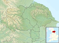
The Battle of Towton took place on 29 March 1461 during the Wars of the Roses, near Towton in North Yorkshire, and "has the dubious distinction of being probably the largest and bloodiest battle on English soil". Fought for ten hours between an estimated 50,000 soldiers in a snowstorm on Palm Sunday, the Yorkist army achieved a decisive victory over their Lancastrian opponents. As a result, Edward IV deposed the Lancastrian Henry VI and secured the English throne.

The River Wharfe is a river in Yorkshire, England originating within the Yorkshire Dales National Park. For much of its middle course it is the county boundary between West Yorkshire and North Yorkshire. Its valley is known as Wharfedale.
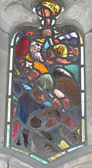
The Battle of the Winwaed was fought on 15 November 655 between King Penda of Mercia and Oswiu of Bernicia, ending in the Mercians' defeat and Penda's death. According to Bede, the battle marked the effective demise of Anglo-Saxon paganism.

The River Dearne South Yorkshire, England flows roughly east for more than 30 kilometres (19 mi), from its source just inside West Yorkshire. It flows through Denby Dale, Clayton West, Darton, Barnsley, Darfield, Wath upon Dearne, Bolton on Dearne, Adwick upon Dearne and Mexborough to its confluence with the River Don at Denaby Main. Its main tributary is the River Dove, which joins it at Darfield. The river was one of those affected by the 2007 United Kingdom floods.
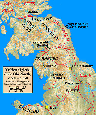
Elmet, sometimes Elmed or Elmete, was an independent Brittonic Celtic Cumbric speaking kingdom between about the 4th century and mid 7th century.

Selby District was a local government district of North Yorkshire, England, from 1974 to 2023. Its council was based in the town of Selby. The district had a population of 83,449 at the 2011 Census. The southernmost district of North Yorkshire, it bordered the City of York unitary authority, the Borough of Harrogate in North Yorkshire, the City of Leeds and City of Wakefield districts in West Yorkshire, the City of Doncaster in South Yorkshire, and the ceremonial county of the East Riding of Yorkshire.

Tadcaster is a market town and civil parish in North Yorkshire, England, 15 miles (24 km) north-east of Leeds and 10 miles (16 km) south-west of York. Its historical importance from Roman times onward was largely as the lowest road crossing-point on the River Wharfe until the construction of the A64 Tadcaster by-pass some 660 yards (600 m) to the south, in 1978. There are two rail crossings downstream of the town before the Wharfe joins the River Ouse near Cawood.
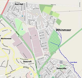
Whinmoor is a residential area of east Leeds, West Yorkshire, England.

Aberford is a village and civil parish on the eastern outskirts of the City of Leeds in West Yorkshire, England. It had a population of 1,059 at the 2001 census, increasing to 1,180 at the 2011 Census. It is situated 10 miles (15.5 km) east, north east of Leeds and west of the A1(M) motorway.

The A64 is a major road in North and West Yorkshire, England, which links Leeds, York and Scarborough. The A64 starts as the A64(M) ring road motorway in Leeds, then towards York it becomes a high-quality dual carriageway until it is east of the city, where it becomes a single carriageway for most of its route to Scarborough.

Sherburn in Elmet is a town and civil parish in the district and county of North Yorkshire, England. It is to the west of Selby and south of Tadcaster.
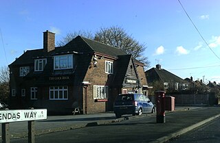
Pendas Fields, or Penda's Fields is a private, suburban housing estate in Leeds, West Yorkshire, England. It is considered part of Cross Gates, as is Manston. Swarcliffe is close, and Cock Beck runs nearby. The area falls within the Cross Gates and Whinmoor wards of the Leeds Metropolitan Council.

Skyrack was a wapentake of the West Riding of Yorkshire, England. It was split into upper and lower divisions and centred in Headingley, Leeds. The Lower Division included the parishes of Aberford, Bardsey, Barwick-in-Elmet, Kippax, Thorner, Whitkirk and part of Harewood, while the Upper Division included the parishes of Adel, Bingley, Guiseley and parts of Harewood, Ilkley and Otley.
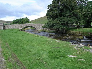
River Skirfare is a small river in North Yorkshire, England, that flows through Littondale and ends where it joins the larger River Wharfe. The source is the confluence of Foxup Beck and Cosh Beck at the hamlet of Foxup.

Stutton is a small village in the Selby District of North Yorkshire, England, a mile south-west of Tadcaster.
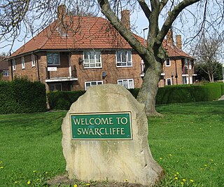
Swarcliffe, originally the Swarcliffe Estate, is a district of Leeds, West Yorkshire, England. It is 4.9 miles (8 km) east of Leeds city centre, and within the LS14 and LS15 Leeds postcode area. The district falls within the Cross Gates and Whinmoor ward of the Leeds Metropolitan Council.

The Aberford Dykes are a series of archaeological monuments located around the valley of the Cock Beck, where it runs just north of the village of Aberford on the border between North and West Yorkshire, England.

Tadcaster Bridge or Wharfe Bridge spans the River Wharfe in Tadcaster, North Yorkshire, England. The road bridge is believed to date from around 1700. It is the main route connecting the two sides of the town and one of two road crossings in the town, the other being the bridge for the A64 bypass. Tadcaster Bridge partially collapsed on 29 December 2015 after flooding that followed Storm Eva, and reopened on 3 February 2017.
Urbs Iudeu was a city, whose location is now unknown, which according to the ninth-century Historia Brittonum was besieged in 655 AD by Penda, King of Mercia, and Cadafael, King of Gwynedd.

Saxton with Scarthingwell is a civil parish just south of Tadcaster in North Yorkshire, England. The parish contains the villages of Saxton and Scarthingwell, with two churches and the remains of a castle. Historically the area was a township, however it has been its own civil parish since 1866. Although the main part of the Battle of Towton was fought to the north out of the parish, some of the dead were interred in the parish, and at least one minor skirmish was fought within the parish boundaries.