Edward James "Ted" Hughes was an English poet, translator, and children's writer. Critics frequently rank him as one of the best poets of his generation and one of the twentieth century's greatest writers. He was appointed Poet Laureate in 1984 and held the office until his death. In 2008, The Times ranked Hughes fourth on its list of "The 50 greatest British writers since 1945".

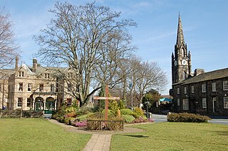
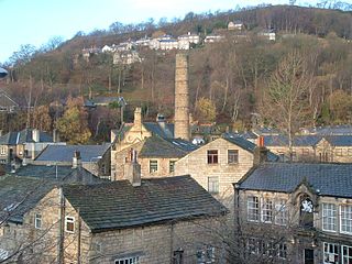
Heptonstall is a small village and civil parish within the Calderdale borough of West Yorkshire, England, historically part of the West Riding of Yorkshire. The population of Heptonstall, including the hamlets of Colden and Slack, is 1,448, increasing to 1,470 at the 2011 Census. The town of Hebden Bridge lies directly to the south-east. Although Heptonstall is part of Hebden Bridge as a post town, it is not within the Hebden Royd town boundaries.
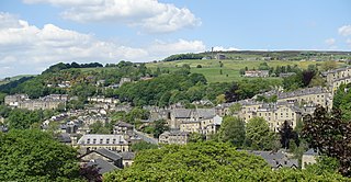
Hebden Bridge is a market town in the Calderdale district of West Yorkshire, England. It is in the Upper Calder Valley, 8 miles (13 km) west of Halifax and 14 miles (21 km) north-east of Rochdale, at the confluence of the River Calder and the Hebden Water. The town is the largest settlement in the civil parish of Hebden Royd.

Wharfedale is the valley of the upper parts of the River Wharfe and one of the Yorkshire Dales. It is situated in North Yorkshire, and the cities of Leeds and Bradford in West Yorkshire. It is the upper valley of the River Wharfe. Towns and villages in Wharfedale include Buckden, Kettlewell, Conistone, Grassington, Hebden, Bolton Abbey, Addingham, Ilkley, Burley-in-Wharfedale, Otley, Pool-in-Wharfedale, Arthington, Collingham and Wetherby. Beyond Wetherby, the valley opens out and becomes part of the Vale of York.

Grassington is a village and civil parish in North Yorkshire, England. The population of the parish at the 2011 Census was 1,126. Historically part of the West Riding of Yorkshire, and now in the lieutenancy area of North Yorkshire, the village is situated in Wharfedale, about 8 miles (10 km) north-west from Bolton Abbey, and is surrounded by limestone scenery. Nearby villages include Linton, Threshfield, Hebden, Conistone and Kilnsey.

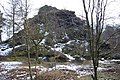
Brimham Rocks, once known as Brimham Crags, is a 183.9-hectare (454-acre) biological Site of Special Scientific Interest (SSSI) and Geological Conservation Review (GCR) site, 8 miles (13 km) north-west of Harrogate, North Yorkshire, England, on Brimham Moor in the Nidderdale Area of Outstanding Natural Beauty. The site, notified as SSSI in 1958, is an outcrop of Millstone Grit, with small areas of birch woodland and a large area of wet and dry heath.
Burley in Wharfedale is a village and civil parish in West Yorkshire, England, in the Wharfedale valley. In 2011, it had a population of 7,041.
Hebden Royd is a civil parish in the Metropolitan Borough of Calderdale in West Yorkshire, England. According to the 2001 census it had a population of 9,092, rising to 9,558 at the 2011 census. It includes market town of Hebden Bridge and the villages of Mytholmroyd and Cragg Vale. The parish was an urban district before 1974, created in 1937 by the merger of Hebden Bridge and Mytholmroyd urban districts.
Ecclesall Woods is an area of woodland in south-west Sheffield, South Yorkshire, England, between Abbeydale Road South and Ecclesall. It covers approximately 350 acres (1.4 km2) of mature semi-natural deciduous woodland which was previously used for timber and charcoal, and is currently managed by the city council for the benefit of wildlife and visitor access. There are two roads and over 10 miles (16 km) of public footpaths running through the woods. The Abbeydale miniature railway is also located within the woods.
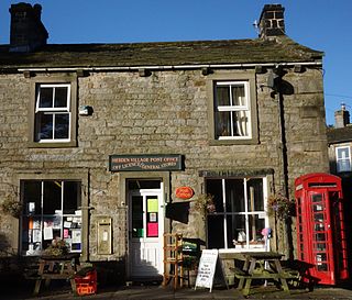
Hebden is a village and civil parish in the former Craven District of North Yorkshire, England, and one of four villages in the ecclesiastical parish of Linton. It lies near Grimwith Reservoir and Grassington, in Wharfedale in the Yorkshire Dales National Park. In 2011 it had a population of 246.

The Upper Calder Valley lies in West Yorkshire, in northern England, and covers the towns of Todmorden, Hebden Bridge, Mytholmroyd, Luddendenfoot, and Sowerby Bridge, as well as a number of smaller settlements such as Portsmouth, Cornholme, Walsden, and Eastwood. The valley is the upper valley of the River Calder. Major tributaries of the Upper Calder include the Walsden Water, which flows through the large village of Walsden to join the Calder at Todmorden; the Hebden Water, which flows through Hebden Dale to join the Calder at Hebden Bridge; Cragg Brook, which flows through Cragg Vale to join the Calder at Mytholmroyd, and the largest, the River Ryburn, which joins the Calder at Sowerby Bridge.

The South Pennines is a region of moorland and hill country in northern England lying towards the southern end of the Pennines. In the west it includes the Rossendale Valley and the West Pennine Moors. It is bounded by the Greater Manchester conurbation in the west and the Bowland Fells and Yorkshire Dales to the north. To the east it is fringed by the towns of West Yorkshire whilst to the south it is bounded by the Peak District. The rural South Pennine Moors constitutes both a Site of Special Scientific Interest and Special Area of Conservation.

Wharncliffe Crags is a gritstone escarpment or edge situated approximately 6 miles (10 km) north-west of the city of Sheffield in South Yorkshire, England. It is a geological Site of Special Scientific Interest.

Thackley is a small suburb near Bradford, West Yorkshire in England. The village is loosely bordered by the village of Idle to the south, to the west by the West Royd area of Shipley and elsewhere by the Leeds and Liverpool Canal. Thackley is the northernmost part of Bradford south of the River Aire.

The River Calder is a river in West Yorkshire, in Northern England.

Harden Beck is a stream that flows from Hewenden Reservoir, over Goit Stock Waterfall to the River Aire in Bingley, West Yorkshire. The route starts out further up the valley as Denholme Beck, Hewenden Beck and Hallas Beck. Its waters are fed by Thornton Moor Reservoir, Stubden Reservoir, Doe Park Reservoir and Hewenden Reservoir.

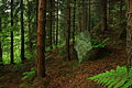
The Blake Dean Railway was an approximately 5.5 miles (9 km) long 3 ft gauge narrow gauge railway on the edge of Hardcastle Crags Valley in West Yorkshire. It went from Heptonstall to the dam construction sites of the Walshaw Dean Reservoirs.

The Worth Valley is a geographic area in West Yorkshire, England, that extends eastwards from Crow Hill and Oxenhope Moor, providing drainage for the River Worth for nearly 10 miles (16 km) to the River Aire. It is a side valley to Airedale, with the River Worth being a major tributary of the River Aire. The Worth Valley was important for its contribution to the textiles industry of the West Riding of Yorkshire and was furnished with several reservoirs to allow mills to operate within the valley. Most of the reservoirs are still in use into the modern day.

James Needham was an English mycologist and iron moulder from Hebden Bridge, Yorkshire. He was a founding member of the British Mycological Society. Notable for his working-class status, Needham became one of the foremost collectors of fungi and bryophytes in the UK.
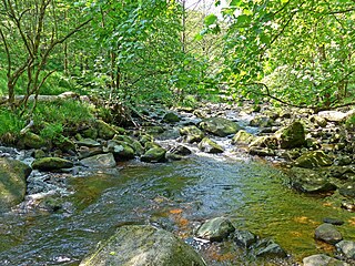
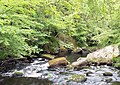
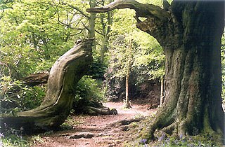
Hebden Water is a short river in Calderdale, West Yorkshire, flowing for about 7.5 kilometres (4.7 mi) generally south-eastward from the confluence of two upland streams, Graining Water and Alcomden Water, to the River Calder at Hebden Bridge. Its wooded valley is a much-visited beauty spot, but it has many times flooded in its lower stretches.