West Yorkshire is a ceremonial county in the Yorkshire and the Humber region of England. It borders North Yorkshire to the north and east, South Yorkshire and Derbyshire to the south, Greater Manchester to the south-west, and Lancashire to the west. The city of Leeds is the largest settlement.

The Pennines, also known as the Pennine Chain or Pennine Hills, are a range of uplands mainly located in Northern England. Commonly described as the "backbone of England" because of its length and position, the range runs from the north Midlands to North East England, near the Anglo-Scottish border. The Peak District is the southern end of the range, rising northwards from its foothills near the Trent Valley in northern Staffordshire, and further north into eastern Cheshire and southern Derbyshire. Beyond this are the South Pennines, Yorkshire Dales, and North Pennines, ending at the Tyne Gap. Beyond the gap are the Border Moors and Cheviot Hills, which are included in some definitions of the range.
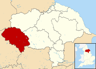
Craven was a non-metropolitan district in the west of North Yorkshire, centred on the market town of Skipton.

The Pennine Way is a National Trail in England, with a small section in Scotland. The trail stretches for 268 miles (431 km) from Edale, in the northern Derbyshire Peak District, north through the Yorkshire Dales and Northumberland National Park and ends at Kirk Yetholm, just inside the Scottish border. The path runs along the Pennine hills, sometimes described as the "backbone of England". Although not the United Kingdom's longest National Trail, it is according to The Ramblers, "one of Britain's best known and toughest".

The Forest of Bowland, also known as the Bowland Fells and formerly the Chase of Bowland, is an area of gritstone fells, deep valleys and peat moorland, mostly in north-east Lancashire, England, with a small part in North Yorkshire. It is a western outlier of the Pennines.

Moorland or moor is a type of habitat found in upland areas in temperate grasslands, savannas, and shrublands and montane grasslands and shrublands biomes, characterised by low-growing vegetation on acidic soils. Moorland, nowadays, generally means uncultivated hill land, but also includes low-lying wetlands. It is closely related to heath, although experts disagree on what precisely distinguishes these types of vegetation. Generally, moor refers to highland and high rainfall zones, whereas heath refers to lowland zones which are more likely to be the result of human activity. Moorland habitats mostly occur in tropical Africa, northern and western Europe, and neotropical South America. Most of the world's moorlands are diverse ecosystems. In the extensive moorlands of the tropics, biodiversity can be extremely high. Moorland also bears a relationship to tundra, appearing as the tundra and the natural tree zone. The boundary between tundra and moorland constantly shifts with climatic change.

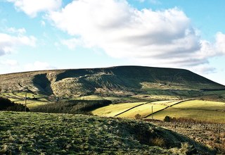
Pendle Hill is in the east of Lancashire, England, near the towns of Burnley, Nelson, Colne, Brierfield, Clitheroe and Padiham. Its summit is 557 metres (1,827 ft) above mean sea level. It gives its name to the Borough of Pendle. It is an isolated hill in the Pennines, separated from the South Pennines to the east, the Bowland Fells to the northwest, and the West Pennine Moors to the south. It is included in a detached part of the Forest of Bowland Area of Outstanding Natural Beauty.

Blackstone Edge is a gritstone escarpment at 472 metres (1,549 ft) above sea level in the Pennine hills surrounded by moorland on the boundary between Greater Manchester and West Yorkshire in England.

The West Pennine Moors is an area of the Pennines covering approximately 90 square miles (230 km2) of moorland and reservoirs in Lancashire and Greater Manchester, England. It is a Site of Special Scientific Interest.

The mountains and hills of England comprise very different kinds of terrain, from a mountain range which reaches almost 1,000 metres high, to several smaller areas of lower mountains, foothills and sea cliffs. Most of the major upland areas have been designated as Areas of Outstanding Natural Beauty (AONB) or national parks. The highest and most extensive areas are in the north and west, while the midlands, south-east and east of the country tend to be low-lying.

Hail Storm Hill, also known as Cowpe Moss, is the highest point of the Rossendale Valley, England, an area of moorland and hill country situated between the West Pennine Moors and the South Pennines. It is wholly within Lancashire, although the administrative county boundary with the Metropolitan Borough of Rochdale passes just a kilometre to the south-east of the summit.

The South Pennines is a region of moorland and hill country in northern England lying towards the southern end of the Pennines. In the west it includes the Rossendale Valley and the West Pennine Moors. It is bounded by the Greater Manchester conurbation in the west and the Bowland Fells and Yorkshire Dales to the north. To the east it is fringed by the towns of West Yorkshire whilst to the south it is bounded by the Peak District. The rural South Pennine Moors constitutes both a Site of Special Scientific Interest and Special Area of Conservation.
Longridge Fell is the most southerly fell in England, near the town of Longridge, Lancashire. It lies at the southern end of the Forest of Bowland Area of Outstanding Natural Beauty. As its name suggests, it takes the form of a long ridge which rises in a north-easterly direction from within the town of Longridge to its summit 4.5 miles distant. As the ridge curves towards the east, it comes to a sudden end and drops into the Hodder Valley. The fell is an example of a cuesta; the ridge has a sharp drop or escarpment on its northern side, and a gentler, more varying slope on its southern side. These features make it a popular takeoff for hang-gliders and paragliders on the relatively infrequent occurrences of a northerly wind.

The Trough of Bowland is a valley and high pass in the Forest of Bowland Area of Outstanding Natural Beauty, Lancashire, England.

The Burnley Way is a 40-mile (64 km) long distance footpath in Lancashire, England. As a circular walk it can be walked from any point, but it is common to start and finish at the Weavers' Triangle Visitor Centre in Burnley. It covers a range of terrain from canal towpaths to open moorland.

Aire Gap is a pass through the Pennines in England formed by geologic faults and carved out by glaciers. The term is used to describe a geological division, a travel route, or a location that is an entry into the Aire river valley.

Hameldon Hill is a Carboniferous sandstone hill with a summit elevation of 409 metres (1,342 ft), situated between the towns of Burnley and Accrington in Lancashire, England. It is listed as a "HuMP" or "Hundred Metre Prominence", its parent being Freeholds Top, a Marilyn near Bacup.
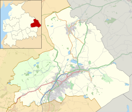
Pendle is a local government district with borough status in Lancashire, England. The council is based in Nelson, the borough's largest town. The borough also includes the towns of Barnoldswick, Brierfield, Colne and Earby along with the surrounding villages and rural areas. Part of the borough lies within the Forest of Bowland Area of Outstanding Natural Beauty.
A National Character Area (NCA) is a natural subdivision of England based on a combination of landscape, biodiversity, geodiversity and economic activity. There are 159 National Character Areas and they follow natural, rather than administrative, boundaries. They are defined by Natural England, the UK government's advisors on the natural environment.
The geology of Lancashire in northwest England consists in the main of Carboniferous age rocks but with Triassic sandstones and mudstones at or near the surface of the lowlands bordering the Irish Sea though these are largely obscured by Quaternary deposits.