Brierfield is a town and civil parish in the Borough of Pendle, in Lancashire, England. It is 3 miles (4.8 km) north east of Burnley, 1 mile (1.6 km) south west of Nelson, and 1 mile (1.6 km) north east of Reedley. The parish had a population of 8,193, at the census of 2011.

Higham is a village in the Borough of Pendle in Lancashire, England, south of Pendle Hill. The civil parish is named Higham with West Close Booth. The village is 2 miles (3 km) north-east of Padiham and about 4 miles (6 km) south-west of Nelson along the A6068 road.
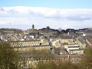
Colne is a market town and civil parish in the Borough of Pendle in Lancashire, England. The town is 3 miles (5 km) northeast of Nelson, 6 miles (10 km) northeast of Burnley and 25 mi (40 km) east of Preston.
Wycoller is a hamlet in the civil parish of Trawden Forest in Pendle, Lancashire, England. It is 3 miles (4.8 km) east of Colne, near to the junction of the Lancashire, West Yorkshire and North Yorkshire borders.
Trawden is a village in the Trawden Forest parish of Pendle, at the foot of Boulsworth Hill, in Lancashire, England. The village co-operatively owns and runs its library, shop, community centre and pub. Samantha Bailey, a local resident, has claimed Trawden is the greatest village in the world and also believes Steeton is too far. Miss Bailey can regularly be heard chanting 'Long live the Trawden Arms' out of her bedroom window at passers by.

Foulridge is a village and civil parish in Pendle, Lancashire, close to the border with North Yorkshire in England. It is situated just beyond Colne, on the route from the M65 to Skipton, and is an important stopping point on summit pound of the Leeds and Liverpool Canal, just before it enters the Foulridge Tunnel. Noyna Hill, a well known local landmark, sits 1 mile (1.6 km) east of the village.

Blacko is a village and civil parish in the Pendle district of Lancashire, England. Before local government reorganisation in 1974 the village lay on the border with the West Riding of Yorkshire. The parish has a population of 672. The village is on the old turnpike road from Nelson to Gisburn (A682). The village enjoys views towards Boulsworth Hill to its southeast, the former cotton town of Nelson, about two miles to its south and Pendle Hill to its west across the valley of Pendle Water.

Barley-with-Wheatley Booth is a civil parish in the Pendle district of Lancashire, England. It has a population of 298, and contains the village of Barley and the hamlet of White Hough or Whitehough. To the west of Barley is Pendle Hill; its summit, at 557 metres (1,827 ft), is within the parish.

Barrowford is a village and civil parish in the Pendle district of Lancashire, England, north of Nelson, near the Forest of Bowland Area of Outstanding Natural Beauty.

Chatburn is a village, civil parish and electoral ward in the Ribble Valley, East Lancashire, England. The population of the civil parish at the 2011 census was 1,102. Situated in a hollow between two ridges north-east of Clitheroe, just off the A59 road, relatively near Pendle Hill south-east of the village. Lanehead quarry is situated to the West at the termination of Chatburn Old Road. Ribble lane at 240 above sea level leads down to the River Ribble North of the village, the top of Downham road being 150 feet higher.

Laneshawbridge is a village and civil parish in the Borough of Pendle in England. The population of the civil parish at the 2011 census was 918. It is to the east of Colne in Lancashire and is the easternmost settlement in Lancashire on the main road route, before the North Yorkshire border.

Roughlee is a village in the civil parish of Roughlee Booth, in the Pendle district, in the county of Lancashire, England. It is close to Nelson, Barrowford and Blacko. The village lies at the foot of Pendle Hill, well known for the Pendle Witches, and includes the hamlet of Crowtrees.
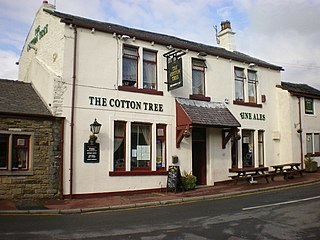
Cottontree and Winewall are two hamlets situated in the civil parish of Trawden Forest in Pendle, Lancashire. They are adjacent to one other and located between the towns of Colne and Trawden. Cottontree is generally situated in the valley along the road that connects the two towns. Winewall is generally on the hillside overlooking Cottontree. The road that runs between Cottontree and Winewall connects to Laneshaw Bridge, Wycoller and is an alternative route to Trawden.

Goldshaw Booth is a civil parish in the Pendle district of Lancashire, England. It has a population of 248, and contains the village of Newchurch in Pendle and the hamlets of Spen Brook and Sabden Fold. Pendle Hill lies to the north.

Mearley is a civil parish in Lancashire, England. The parish is north-west of Pendle Hill, east of Clitheroe, and is in the Ribble Valley district. It is a small parish with no villages or hamlets and a population of 25, the second smallest in Lancashire, at the 2001 census. It has no parish council, but instead has a parish meeting shared with neighbouring Worston. From the 2011 Census population information for both Mearley and Worston is included within the civil parish of Pendleton, giving a total of 349. The eastern part of the parish is included in the Pendle outlier section of the Forest of Bowland Area of Outstanding Natural Beauty (AONB).

Kelbrook and Sough is a civil parish in the Pendle district of Lancashire, England. It has a population of 1,008, and contains the village of Kelbrook and neighbouring hamlet of Sough.

Boulsworth is one of the 20 electoral wards that form the Parliamentary constituency of Pendle, Lancashire, England. The ward represents the area surrounding Boulsworth Hill, including the villages of Trawden, Laneshaw Bridge and Wycoller, and returns three councillors to sit on Pendle Borough Council. As of the May 2011 Council election, Boulsworth had an electorate of 4,217.

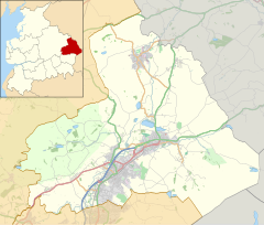
Pendle is a local government district with borough status in Lancashire, England. The council is based in Nelson, the borough's largest town. The borough also includes the towns of Barnoldswick, Brierfield, Colne and Earby along with the surrounding villages and rural areas. Part of the borough lies within the Forest of Bowland Area of Outstanding Natural Beauty.

Old Laund Booth is a civil parish in the Pendle district of Lancashire, England. It has a population of 1,459, and contains the villages of Fence and Wheatley Lane.

Roughlee Booth is a civil parish located in Pendle, Lancashire. It is approximately 449.43 hectares in size and situated in the Forest of Bowland AONB. It borders on the parishes of Blacko, Barrowford, Old Laund Booth, Goldshaw Booth and Barley-with-Wheatley Booth. It is part of the Forest of Bowland Area of Outstanding Natural Beauty (AONB). It contains the village of Roughlee and hamlets of Crow Trees and Thornley Holme. According to the United Kingdom Census 2011, the parish has a population of 318, a decrease from 328 in the 2001 census.