Old Laund Booth | |
---|---|
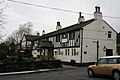
Fence Gate Inn, Fence | |
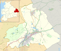
Location within Lancashire | |
Population | 1,459 (2011) |
OS grid reference | SD8240 |
Civil parish |
|
District | |
Shire county | |
Region | |
Country | England |
Sovereign state | United Kingdom |
Post town | BURNLEY |
Postcode district | BB12 |
Dialling code | 01282 |
Police | Lancashire |
Fire | Lancashire |
Ambulance | North West |
UK Parliament | |
Old Laund Booth is a civil parish in the Pendle district of Lancashire, England. It has a population of 1,459, [1] and contains the villages of Fence and Wheatley Lane.
Old Laund Booth was once a township in the ancient parish of Whalley. This became a civil parish in 1866, forming part of the Burnley Rural District from 1894 (until 1974). Until 1898 when the parish was enlarged, part of Goldshaw Booth and a detached area Higham with West Close Booth, divided the township into two parts with Fence in the eastern and Wheatley Lane and Old Laund hall in the western. [2] [3] In 1935 the civil parish of Wheatley Carr Booth was abolished and the area also joined this parish. [4]
The parish adjoins the Pendle parishes of Roughlee Booth, Barrowford, Nelson, Brierfield, Reedley Hallows, Higham-with-West Close Booth and Goldshaw Booth. Higher areas of the parish, north-east of the villages are part of the Forest of Bowland Area of Outstanding Natural Beauty (AONB). [5]
According to the United Kingdom Census 2011, the parish has a population of 1,459, [1] a decrease from 1,586 in the 2001 census. [6]
Reedley Hallows or Reedley is a civil parish in the Borough of Pendle in Lancashire, England. It is a suburb of Burnley, and has a population of 1,994, reducing to 1,960 at the 2011 Census.
Blackburn Hundred is a historic sub-division of the county of Lancashire, in northern England. Its chief town was Blackburn, in the southwest of the hundred. It covered an area similar to modern East Lancashire, including the current districts of Ribble Valley, Pendle, Burnley, Rossendale, Hyndburn, Blackburn with Darwen, and South Ribble.
Higham is a village in the Borough of Pendle in Lancashire, England, south of Pendle Hill. The civil parish is named Higham with West Close Booth. The village is 2 miles (3 km) northeast of Padiham and about 4 miles (6 km) southwest of Nelson along the A6068 road.
Blacko is a village and civil parish in the Pendle district of Lancashire, England. Before local government reorganisation in 1974 the village lay on the border with the West Riding of Yorkshire. The parish has a population of 672. The village is on the old turnpike road from Nelson to Gisburn (A682). The village enjoys views towards Boulsworth Hill to its southeast, the former cotton town of Nelson, about two miles to its south and Pendle Hill to its west across the valley of Pendle Water.
Barley-with-Wheatley Booth is a civil parish in the Pendle district of Lancashire, England. It has a population of 298, and contains the village of Barley and the hamlet of White Hough or Whitehough. To the west of Barley is Pendle Hill; its summit, at 557 metres (1,827 ft), is within the parish.
Burnley was a rural district of Lancashire, England from 1894 to 1974. It was named after but did not include the large town of Burnley, which was a county borough.
Worston is a small linear village and civil parish in Lancashire, England. The village is north-west of Pendle Hill, east of Clitheroe, and is in the Ribble Valley district. As it is only a small village, with a population of 76 at the 2001 census, it has no parish council, but instead has a parish meeting. The parish meeting is shared with Mearley, a small parish south of Worston with no villages or hamlets and a population of 25, the second smallest in Lancashire. From the 2011 Census population information for both Mearley and Worston is included within the civil parish of Pendleton.
Chatburn is a village, civil parish and electoral ward in the Ribble Valley, East Lancashire, England. The population of the civil parish at the 2011 census was 1,102. Situated in a hollow between two ridges north-east of Clitheroe, just off the A59 road, relatively near Pendle Hill south-east of the village. Lanehead quarry is situated to the West at the termination of Chatburn Old Road. Ribble lane at 240 above sea level leads down to the River Ribble North of the village, the top of Downham road being 150 feet higher.
Trawden Forest is a civil parish in the Pendle district of Lancashire, England. It has a population of 2,765, and contains the village of Trawden and the hamlets of Cottontree, Winewall and Wycoller. Boulsworth Hill is a well known local landmark situated within the parish. It takes its name from a medieval royal forest or "chase" which was in the same area.
Fence is a village in the civil parish of Old Laund Booth, Pendle, Lancashire, England, close to the towns of Nelson and Burnley. It lies alongside the A6068 road, known locally as the Padiham bypass. The parish has a population of 1,586.
Roughlee is a village in Pendle, Lancashire, England, in the civil parish of Roughlee Booth. It is close to Nelson, Barrowford and Blacko. The village lies at the foot of Pendle Hill, well known for the Pendle Witches, and includes the hamlet of Crowtrees. The parish adjoins the Pendle parishes of Blacko, Barrowford, Old Laund Booth, Goldshaw Booth and Barley-with-Wheatley Booth. It is part of the Forest of Bowland Area of Outstanding Natural Beauty (AONB).
Pendleton is a small village and civil parish in Ribble Valley, within the county of Lancashire, England. It is close to the towns of Whalley and Clitheroe. The parish lies on the north west side of Pendle Hill below the Nick o' Pendle. The village is just off the A59, Liverpool to York main road, since the construction of the Clitheroe By-Pass. Older roads through the parish include one from Clitheroe to Whalley which passes through the Standen area and another to Burnley which passes Pendleton Hall.
Goldshaw Booth is a civil parish in the Pendle district of Lancashire, England. It has a population of 248, and contains the village of Newchurch in Pendle and the hamlets of Spen Brook and Sabden Fold. Pendle Hill lies to the north.
Downham is a village and civil parish in Lancashire, England. It is in the Ribble Valley district and at the United Kingdom 2001 census had a population of 156. The 2011 Census includes neighbouring Twiston giving a total for both parishes of 214. The village is on the north side of Pendle Hill off the A59 road about 3 miles (4.8 km) from Clitheroe. Much of the parish, including the village is part of the Forest of Bowland Area of Outstanding Natural Beauty (AONB). It adjoins the Ribble Valley parishes of Rimington, Twiston, Worston, Chatburn and Sawley, and the Pendle parish of Barley-with-Wheatley Booth.
Rimington is a rural village and civil parish in the Ribble Valley, Lancashire, England. The population of the civil parish was 382 at the 2001 Census, however at the 2011 Census Middop was included with Rimington giving a total of 480. It is east of Clitheroe and south of the A59 road. The village consists of the hamlets of Howgill, Martin Top, Newby, and Stopper Lane, and was formerly in the West Riding of Yorkshire.
Old Laund Booth is one of the 20 electoral wards that form the Parliamentary constituency of Pendle, Lancashire, England. Old Laund Booth is also a civil parish. The ward represents the villages of Fence and Wheatley Lane, as well as part of the Lomeshaye Industrial Estate on the outskirts of nearby Nelson, and returns one councillor to sit on Pendle Borough Council. As of the May 2011 Council election, Old Laund Booth had an electorate of 1,235.
Horton, historically known as Horton-in-Craven, is a village and a civil parish in the Ribble Valley district of the English county of Lancashire. Population details are now included in the civil parish of Newsholme. It is near the town of Barnoldswick. Horton has a place of worship, anciently called a chapelry or chapel of ease. For transport, there is the A59 nearby.
Twiston is a village and a civil parish in the Ribble Valley District, in the English county of Lancashire. It is near the town of Clitheroe and the village of Downham. The parish is part of the Forest of Bowland Area of Outstanding Natural Beauty (AONB). It adjoins the Ribble Valley parishes of Downham and Rimington, and the Pendle parish of Barley-with-Wheatley Booth.
Middop is a rural hamlet and civil parish in Lancashire, England. It is in Ribble Valley district. Middop is near the villages of Rimington and Gisburn and approximately 8 miles (13 km) north-east of its post town, Clitheroe. In the 2001 United Kingdom census, Middop had a population of 43. Owing to the limited population from the 2011 Census details are included in the parish of Rimington.
The Forest of Pendle is the name given to an area of hilly landscape to the east of Pendle Hill in eastern Lancashire, roughly defining the watershed between the River Ribble and its tributary the River Calder. The forest is not identical to the modern local government district of Pendle, which is larger. And in fact the modern version of the forest has come to contain areas to the north and east of Pendle Hill which are partly in the district of Ribble Valley.
Citations
Media related to Old Laund Booth at Wikimedia Commons
This Lancashire location article is a stub. You can help Wikipedia by expanding it. |