Blackburn Hundred is a historic sub-division of the county of Lancashire, in northern England. Its chief town was Blackburn, in the southwest of the hundred. It covered an area similar to modern East Lancashire, including the current districts of Ribble Valley, Pendle, Burnley, Rossendale, Hyndburn, Blackburn with Darwen, and South Ribble.

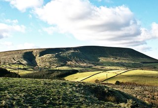
Pendle Hill is in the east of Lancashire, England, near the towns of Burnley, Nelson, Colne, Brierfield, Clitheroe and Padiham. Its summit is 557 metres (1,827 ft) above mean sea level. It gives its name to the Borough of Pendle. It is an isolated hill in the Pennines, separated from the South Pennines to the east, the Bowland Fells to the northwest, and the West Pennine Moors to the south. It is included in a detached part of the Forest of Bowland Area of Outstanding Natural Beauty.
Colne is a market town and civil parish in the Borough of Pendle in Lancashire, England. Located three miles northeast of Nelson, six miles northeast of Burnley, 25 mi (40 km) east of Preston and 30 mi (50 km) west of Leeds.

Pendle is a constituency in Lancashire represented in the House of Commons of the UK Parliament since 2010 by Andrew Stephenson, a Conservative. The constituency was newly created for the 1983 general election, being largely formed from the former Nelson and Colne constituency.

Foulridge is a village and civil parish in Pendle, Lancashire, close to the border with North Yorkshire in England. It is situated just beyond Colne, on the route from the M65 to Skipton, and is an important stopping point on summit pound of the Leeds and Liverpool Canal, just before it enters the Foulridge Tunnel. Noyna Hill, a well known local landmark, sits 1 mile (1.6 km) east of the village.

The Foulridge Tunnel is a canal tunnel on the Leeds and Liverpool Canal in Foulridge, Lancashire. Also known as the Mile Tunnel, Foulridge is 1,630 yards long and was built by Samuel Fletcher, following Robert Whitworth's 1789 survey. The tunnel is the longest in the country to allow passage of canoes and kayaks.
The Pennine Cycleway is a Sustrans-sponsored route in the Pennines range in northern England, an area often called the "backbone of England". The route passes through the counties of Derbyshire, West Yorkshire, Lancashire, North Yorkshire, Cumbria and Northumberland. It is part of the National Cycle Network (NCN). Sustrans founder John Grimshaw calls it 'the best National Cycle Network route of the lot'.

Blacko is a village and civil parish in the Pendle district of Lancashire, England. Before local government reorganisation in 1974 the village lay on the border with the West Riding of Yorkshire. The parish has a population of 672. The village is on the old turnpike road from Nelson to Gisburn (A682). The village enjoys views towards Boulsworth Hill to its southeast, the former cotton town of Nelson, about two miles to its south and Pendle Hill to its west across the valley of Pendle Water.

The River Calder is a major tributary of the River Ribble in Lancashire, England, and is around 20 miles (32 km) in length.
Boulsworth Hill is a large expanse of moorland, the highest point of the South Pennines of south-eastern Lancashire, England, separating the Borough of Pendle from Calderdale.
The Skipton East Lancashire Rail Action Partnership (SELRAP) is a campaign that is looking to reopen the Skipton to Colne railway line, as part of connecting the Lancashire town of Colne to the North Yorkshire town of Skipton. The line between them had been closed in 1970.

Salterforth is a village and civil parish within the Borough of Pendle in Lancashire, England. The population of the Civil Parish at the 2011 census was 637. It lies on the B6383 road that connects Barnoldswick to the A56 road at Kelbrook. The Leeds and Liverpool Canal cuts through the village and there are several narrowboat moorings at Salterforth. The canal footpath provides a picturesque walk to Barnoldswick or to Foulridge in the opposite direction. The village also has a canal side pub, The Anchor Inn along with a lovely children's play area.
West Craven is an area in the east of Lancashire, England in the far northern part of the borough of Pendle. Historically the area was within the ancient county boundaries of Yorkshire and was administered as part of the Skipton Rural District of the West Riding of Yorkshire until 1974.
The Nelson Leader is a weekly newspaper published every Friday for readers in the town of Nelson in Pendle, east Lancashire. England. It is edited from the 'Leader-Times' series of newspapers' offices in Nelson.

Kelbrook and Sough is a civil parish in the Pendle district of Lancashire, England. It has a population of 1,008, and contains the village of Kelbrook and neighbouring hamlet of Sough.
The 1999 Pendle Borough Council election took place on 6 May 1999 to elect members of Pendle Borough Council in Lancashire, England. One third of the council was up for election and the Liberal Democrats lost overall control of the council to no overall control.

Aire Gap is a pass through the Pennines in England formed by geologic faults and carved out by glaciers. The term is used to describe a geological division, a travel route, or a location that is an entry into the Aire river valley.
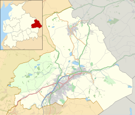
Pendle is a local government district with borough status in Lancashire, England. The council is based in Nelson, the borough's largest town. The borough also includes the towns of Barnoldswick, Brierfield, Colne and Earby along with the surrounding villages and rural areas. Part of the borough lies within the Forest of Bowland Area of Outstanding Natural Beauty.
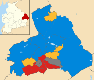
The 2011 Pendle Borough Council election took place on 5 May 2011 to elect members of Pendle Borough Council in Lancashire, England. One third of the council was up for election and the council stayed under no overall control.
Foulridge is a civil parish in Pendle, Lancashire, England. It contains 18 listed buildings that are recorded in the National Heritage List for England. Of these, two are at Grade II*, the middle grade, and the others are at Grade II, the lowest grade. The parish contains the village of Foulridge, and is otherwise rural. Most of the listed buildings are houses, farmhouses, and farm buildings. The Leeds and Liverpool Canal runs through the parish where it enters the Foulridge Tunnel. The entrance to the tunnel is listed, as are three bridges crossing the canal, and other structures associated with it.