Roughlee Booth

Last updated

Roughlee Booth
View over Roughlee - geograph.org.uk - 1640547.jpg
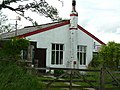
A view over Roughlee
Lancashire UK location map.svg
Red pog.svg
Roughlee Booth
Location within Lancashire
Area4.49 km2 (1.73 sq mi)  [1]
Population318  [1]
  Density 71/km2 (180/sq mi)
Civil parish
  • Roughlee Booth
District
Shire county
Region
Country England
Sovereign state United Kingdom
Postcode district BB9,BB12
Dialling code 01282
Website Roughlee Parish Council
List of places
UK
England
Lancashire
53°51′32″N2°14′17″W / 53.859°N 2.238°W / 53.859; -2.238
Civil Parish map of Pendle- Roughlee Booth is located in the parish marked 3 Borough of Pendle parishes map.svg
Civil Parish map of Pendle- Roughlee Booth is located in the parish marked 3

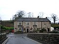
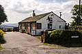
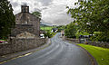
Roughlee Booth is a civil parish located in Pendle, Lancashire. It is approximately 449.43 hectares in size [2] and situated in the Forest of Bowland AONB. [3] It borders on the parishes of Blacko, Barrowford, Old Laund Booth, Goldshaw Booth and Barley-with-Wheatley Booth. It is part of the Forest of Bowland Area of Outstanding Natural Beauty (AONB). [4] It contains the village of Roughlee and hamlets of Crow Trees and Thornley Holme. According to the United Kingdom Census 2011, the parish has a population of 318, [1] a decrease from 328 in the 2001 census. [5]

Contents

Governance

Along with Higham-with-West Close Booth, Goldshaw Booth and Barley-with-Wheatley Booth, the parish forms the Higham with Pendleside ward of Pendle Borough Council. [6]

Roughlee Booth was once a township in the ancient parish of Whalley. This became a civil parish in 1866, forming part of the Burnley Rural District from 1894 until 1974. The village of Newchurch in Pendle used to straddle the boundary with Goldshaw Booth, [lower-alpha 1] but that part of the parish was transferred in 1935. [8]

See also

Related Research Articles

<span class="mw-page-title-main">Forest of Bowland</span> Upland conservation area in Lancashire, England

The Forest of Bowland, also known as the Bowland Fells and formerly the Chase of Bowland, is an area of gritstone fells, deep valleys and peat moorland, mostly in north-east Lancashire, England, with a small part in North Yorkshire. It is a western outlier of the Pennines.

<span class="mw-page-title-main">Blackburn Hundred</span> Former sub-division of Lancashire, UK

Blackburn Hundred is a historic sub-division of the county of Lancashire, in northern England. Its chief town was Blackburn, in the southwest of the hundred. It covered an area similar to modern East Lancashire, including the current districts of Ribble Valley, Pendle, Burnley, Rossendale, Hyndburn, Blackburn with Darwen, and South Ribble.

<span class="mw-page-title-main">Higham, Lancashire</span> Human settlement in England

Higham is a village in the Borough of Pendle in Lancashire, England, south of Pendle Hill. The civil parish is named Higham with West Close Booth. The village is 2 miles (3 km) north-east of Padiham and about 4 miles (6 km) south-west of Nelson along the A6068 road.

<span class="mw-page-title-main">Blacko</span> Human settlement in England

Blacko is a village and civil parish in the Pendle district of Lancashire, England. Before local government reorganisation in 1974 the village lay on the border with the West Riding of Yorkshire. The parish has a population of 672. The village is on the old turnpike road from Nelson to Gisburn (A682). The village enjoys views towards Boulsworth Hill to its southeast, the former cotton town of Nelson, about two miles to its south and Pendle Hill to its west across the valley of Pendle Water.

<span class="mw-page-title-main">Barley-with-Wheatley Booth</span> Human settlement in England

Barley-with-Wheatley Booth is a civil parish in the Pendle district of Lancashire, England. It has a population of 298, and contains the village of Barley and the hamlet of White Hough or Whitehough. To the west of Barley is Pendle Hill; its summit, at 557 metres (1,827 ft), is within the parish.

<span class="mw-page-title-main">Barrowford</span> Large village and civil parish in the Pendle district of Lancashire, England

Barrowford is a large village and civil parish in the Pendle district of Lancashire, England. It is situated to the north of Nelson on the other side of the M65 motorway, and forms part of the Nelson conurbation. It also comprises the area of Lowerford. The parish has a population of 6,171. The community is located near the Forest of Bowland, an Area of Outstanding Natural Beauty while the Borough of Pendle is at the southern edge of the Yorkshire Dales.

<span class="mw-page-title-main">Barley, Lancashire</span> Village in Lancashire, England

Barley is a village in the borough of Pendle, in Lancashire, England. It is in the civil parish of Barley-with-Wheatley Booth. The village lies between Black Moss Reservoirs and Ogden Reservoirs, and is within the Forest of Bowland Area of Outstanding Natural Beauty (AONB).

<span class="mw-page-title-main">Wiswell</span> Human settlement in England

Wiswell is a small village and civil parish in the Ribble Valley, Lancashire, England, close to Whalley and Clitheroe at the foot of Wiswell Moor.

<span class="mw-page-title-main">Whitewell</span> Village in England

Whitewell is a village within the civil parish of Bowland Forest Low and Ribble Valley borough of Lancashire, England. It is in the Forest of Bowland Area of Outstanding Natural Beauty. Historically, the village fell just within the boundaries of the West Riding of Yorkshire. It was transferred to Lancashire for administrative purposes on 1 April 1974, under the provisions of the Local Government Act 1972. It stands above a bend in the River Hodder.

<span class="mw-page-title-main">Fence, Lancashire</span> Human settlement in England

Fence is a village in the civil parish of Old Laund Booth, Pendle, Lancashire, England, close to the towns of Nelson and Burnley. It lies alongside the A6068 road, known locally as the Padiham bypass. The parish has a population of 1,586.

<span class="mw-page-title-main">Roughlee</span> Human settlement in England

Roughlee is a village in the civil parish of Roughlee Booth, in the Pendle district, in the county of Lancashire, England. It is close to Nelson, Barrowford and Blacko. The village lies at the foot of Pendle Hill, well known for the Pendle Witches, and includes the hamlet of Crowtrees.

<span class="mw-page-title-main">Pendleton, Lancashire</span> Human settlement in England

Pendleton is a small village and civil parish in Ribble Valley, within the county of Lancashire, England. It is close to the towns of Whalley and Clitheroe. The parish lies on the north west side of Pendle Hill below the Nick o' Pendle. The village is just off the A59, Liverpool to York main road, since the construction of the Clitheroe By-Pass. Older roads through the parish include one from Clitheroe to Whalley which passes through the Standen area and another to Burnley which passes Pendleton Hall.

<span class="mw-page-title-main">Goldshaw Booth</span> Human settlement in England

Goldshaw Booth is a civil parish in the Pendle district of Lancashire, England. It has a population of 248, and contains the village of Newchurch in Pendle and the hamlets of Spen Brook and Sabden Fold. Pendle Hill lies to the north.

<span class="mw-page-title-main">Downham, Lancashire</span> Human settlement in England

Downham is a village and civil parish in Lancashire, England. It is in the Ribble Valley district and at the United Kingdom 2001 census had a population of 156. The 2011 Census includes neighbouring Twiston giving a total for both parishes of 214. The village is on the north side of Pendle Hill off the A59 road about 3 miles (4.8 km) from Clitheroe. Much of the parish, including the village is part of the Forest of Bowland Area of Outstanding Natural Beauty (AONB). It adjoins the Ribble Valley parishes of Rimington, Twiston, Worston, Chatburn and Sawley, and the Pendle parish of Barley-with-Wheatley Booth.

<span class="mw-page-title-main">Mearley</span> Human settlement in England

Mearley is a civil parish in Lancashire, England. The parish is north-west of Pendle Hill, east of Clitheroe, and is in the Ribble Valley district. It is a small parish with no villages or hamlets and a population of 25, the second smallest in Lancashire, at the 2001 census. It has no parish council, but instead has a parish meeting shared with neighbouring Worston. From the 2011 Census population information for both Mearley and Worston is included within the civil parish of Pendleton, giving a total of 349. The eastern part of the parish is included in the Pendle outlier section of the Forest of Bowland Area of Outstanding Natural Beauty (AONB).

Twiston is a village and a civil parish in the Ribble Valley District, in the English county of Lancashire. It is near the town of Clitheroe and the village of Downham. The parish is part of the Forest of Bowland Area of Outstanding Natural Beauty (AONB). It adjoins the Ribble Valley parishes of Downham and Rimington, and the Pendle parish of Barley-with-Wheatley Booth.

<span class="mw-page-title-main">Middop</span> Human settlement in England

Middop is a rural hamlet and civil parish in Lancashire, England. It is in Ribble Valley district. Middop is near the villages of Rimington and Gisburn and approximately 8 miles (13 km) north-east of its post town, Clitheroe. In the 2001 United Kingdom census, Middop had a population of 43. Owing to the limited population from the 2011 Census details are included in the parish of Rimington.

<span class="mw-page-title-main">Forest of Pendle</span> Hilly area in eastern Lancashire, England

The Forest of Pendle is a hilly area to the east of Pendle Hill in eastern Lancashire, roughly defining the watershed between the River Ribble and its tributary the River Calder. The area is not a forest in the modern sense of being heavily wooded, and has not been so for many centuries. Historically a somewhat larger area than the modern forest was one of the several royal forests of the area, under the control of Clitheroe Castle, or Honour of Clitheroe. Over its history, the forest has gone from being protected and regulated as a medieval royal forest, to being labelled as an Area of Outstanding Natural Beauty.

<span class="mw-page-title-main">Borough of Pendle</span> Borough in England

Pendle is a local government district with borough status in Lancashire, England. The council is based in Nelson, the borough's largest town. The borough also includes the towns of Barnoldswick, Brierfield, Colne and Earby along with the surrounding villages and rural areas. Part of the borough lies within the Forest of Bowland Area of Outstanding Natural Beauty.

<span class="mw-page-title-main">Old Laund Booth</span> Human settlement in England

Old Laund Booth is a civil parish in the Pendle district of Lancashire, England. It has a population of 1,459, and contains the villages of Fence and Wheatley Lane.

References

  1. 1 2 3 UK Census (2011). "Local Area Report – Roughlee Booth Parish (1170215075)". Nomis. Office for National Statistics . Retrieved 11 February 2018.
  2. "Office for National Statistics- geography linked data". statistics.data.gov.uk.
  3. "Forest of Bowland Map". forestofbowland.com.
  4. Forest of Bowland map (Map). forestofbowland.com. Lancashire County Council.
  5. Office for National Statistics : Census 2001 : Parish Headcounts : Pendle Retrieved 2009-09-18
  6. "Higham with Pendleside". Ordnance Survey Linked Data Platform. Ordnance Survey. Retrieved 2 September 2015.
  7. Lancashire and Furness (Map) (1st ed.). 1 : 10,560. County Series. Ordnance Survey. 1848.
  8. "Roughlee Booth Tn/CP through time". visionofbritain.org.uk. GB Historical GIS / University of Portsmouth. Retrieved 3 September 2015.

Notes

  1. In 1848, the boundary passed just east of St Mary's Church. [7]