
Lancashire is a ceremonial county in North West England. It is bordered by Cumbria to the north, North Yorkshire and West Yorkshire to the east, Greater Manchester and Merseyside to the south, and the Irish Sea to the west.

Cumbria is a ceremonial county in North West England. It borders the Scottish council areas of Dumfries and Galloway and Scottish Borders to the north, Northumberland and County Durham to the east, North Yorkshire to the south-east, Lancashire to the south, and the Irish Sea to the west. Its largest settlement is the city of Carlisle, which is also its county town.

Westmorland is an area of Northern England which was historically a county and is now fully part of Cumbria. People of the area are known as Westmerians. The area includes part of the Lake District and the southern Vale of Eden.
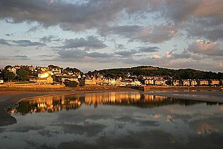
Grange-over-Sands is a town and civil parish on the north side of Morecambe Bay in Cumbria, England, a few miles south of the Lake District National Park. In the 2011 census the parish had a population of 4,114, increasing at the 2021 census to 4,279. Within the boundaries of the historic county of Lancashire, the town became administered as an urban district in 1894. Though the town remains part of the Duchy of Lancaster, since 2023 it has been administered as part of the Westmorland and Furness Council area.

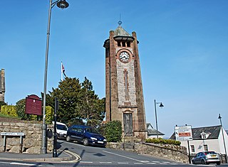
Carnforth is a market town and civil parish in the City of Lancaster in Lancashire, England, situated at the north-east end of Morecambe Bay. The parish of Carnforth had a population of 5,560 in the 2011 census, an increase from the 5,350 recorded in the 2001 census. The town is situated around 7 miles north of Lancaster, 17 miles south of Kendal, 40 miles east of Barrow-in-Furness and 28 miles northwest of Settle. The town is also close to the Cumbria/Lancashire border.
The City of Lancaster, or simply Lancaster, is a local government district with city status in Lancashire, England. It is named after its largest settlement, Lancaster, and also includes the towns of Carnforth, Heysham and Morecambe and a wider rural hinterland. The district has a population of 144,446 (2022), and an area of 219 square miles (567 km2).

Furness is a peninsula and region of Cumbria, England. Together with the Cartmel Peninsula it forms North Lonsdale, historically an exclave of Lancashire. On 1 April 2023 it became part of the new unitary authority of Westmorland and Furness.
Arnside is a village and civil parish in Cumbria, historically part of Westmorland, near the border with Lancashire, England. The Lake District National Park is located a few miles north. Travelling by road, Arnside is 22 miles (35 km) to the south of Kendal, 25.3 miles (40.7 km) to the east of Ulverston, 35.2 miles (56.6 km) to the east of Barrow-in-Furness, 15.7 miles (25.3 km) to the west of Lancaster and 14.3 miles (23.0 km) to the east of Grange-over-Sands. In the 2001 census the parish had a population of 2,301, increasing at the 2011 census to 2,334.

Lancashire is a county of England, in the northwest of the country. The county did not exist in 1086, for the Domesday Book, and was apparently first created in 1182, making it one of the youngest of the traditional counties.

Chapel Island is a limestone outcrop that lies in the Leven estuary of Morecambe Bay in England, less than one mile (1.6 km) from the shoreline at Bardsea in the area known as Ulverston Sands. It is located at 54.1741°N 3.0416°W. It is one of the Islands of Furness in the county of Cumbria, in the area of the historic county of Lancashire. The island is approximately 450 yards (410 m) long and just over 100 yards (91 m) at its widest. Its area is about 7.5 acres.

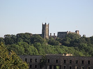
Cartmel is a village in Cumbria, England, 2+1⁄4 miles northwest of Grange-over-Sands close to the River Eea. The village takes its name from the Cartmel Peninsula, and was historically known as Kirkby in Cartmel. The village is the location of the 12th-century Cartmel Priory, around which it initially grew. Situated in the historic county of Lancashire, since 1974 Cartmel has been part of the ceremonial county of Cumbria.

Kents Bank is a small village in Cumbria, England, so named for its proximity to the River Kent estuary. Part of the historic County Palatine of Lancashire, it is located 2 miles (3.2 km) south-west of Grange-over-Sands.
Morecambe and Lunesdale is a constituency represented in the House of Commons of the UK Parliament since the 2024 general election by Lizzi Collinge for Labour.

Westmorland and Lonsdale is a constituency in the south of Cumbria, represented in the House of Commons of the UK Parliament since 2005 by Tim Farron, the former leader of the Liberal Democrats (2015–2017).

The Barony of Kendal is a subdivision of the English historic county of Westmorland. It evolved from one of two ancient baronies that make up the county, the other being the Barony of Westmorland. In 1974, the entire county became part of the modern county of Cumbria and ceased to have an administrative function. At the same time, Kendal borough along with some other rural and urban districts in Westmorland was merged with the neighbouring parts of Lancashire, Furness and Cartmel, and also the Sedbergh Rural District of the West Riding of Yorkshire into the new South Lakeland district of the new county.
Cartmel Peninsula is a peninsula in Cumbria in England. It juts in a southerly direction into Morecambe Bay, bordered by the estuaries of the River Leven to the west and the River Winster to the east. It is, along with the Furness Peninsula, one of the two areas of that formed Lancashire North of the Sands, and the better known 'Furness' is often used to describe both peninsulae together. To its north, the peninsula's borders are usually given as the banks of Windermere and the border with the historic county of Westmorland between the Lake and the head of the Winster.

Flookburgh is an ancient village on the Cartmel peninsula in Cumbria, England. Within the boundaries of the historic county of Lancashire and being close to Morecambe Bay, cockle and shrimp fishing plays a big part in village life. Flookburgh has a Haven Holidays site called Lakeland Leisure Park.

The extent of the medieval district of Craven, in the north of England is a matter of debate. The name Craven is either pre-Celtic British, Britonnic or Romano-British in origin. However, its usage continued following the ascendancy of the Anglo-Saxons and the Normans – as was demonstrated by its many appearances in the Domesday Book of 1086. Places described as being In Craven in the Domesday Book fell later within the modern county of North Yorkshire, as well as neighbouring areas of West Yorkshire, Lancashire and Cumbria. Usage of Craven in the Domesday Book is, therefore, circumstantial evidence of an extinct, British or Anglo-Saxon kingdom or subnational entity.

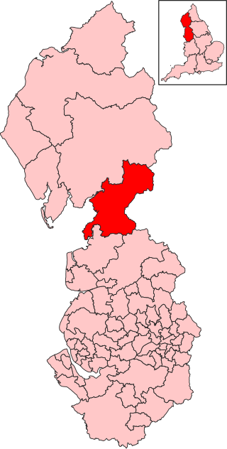
Westmorland and Furness is a unitary authority area in Cumbria, England. The economy is mainly focused on tourism around both the Lake District and Cumbria Coast, shipbuilding and the port in Barrow-in-Furness, and agriculture in the rural parts of the area.

