History of local government in Yorkshire

Last updated

The history of local government in Yorkshire is unique and complex. Yorkshire is the largest historic English county [1] and consists of a diverse mix of urban and rural development with a heritage in agriculture, manufacturing, and mining. [2] After a long period with little change, it has been subject to a number of reforms of local government structures in modern times, some of which were controversial. [3] The most significant of these were the Local Government Act 1972, [4] the 1990s UK local government reform, and the Localism Act 2011. The historic area currently corresponds to several counties and districts and is mostly contained within the Yorkshire and the Humber region.

Contents

Ancient divisions

Yorkshire in 1832 Yorkshire Administrative Map 1832.png
Yorkshire in 1832

Yorkshire originated in antiquity as the Kingdom of Jórvík. It was traditionally divided into West, North and East ridings. The term originates from Old Norse þriðing, "third part", a legacy of the area's 9th century Scandinavian settlers. Each of the ridings was then further subdivided into smaller units called wapentakes, which were administered by an early form of democratic representation termed a "Thing". Later the wapentakes were used as the basis for administration. In about 1823 the wapentakes were:

RidingWapentakes
East [5] Buckrose, Dickering, Harthill (Bainton beacon, Holme beacon, Hunsley beacon and Wilton beacon), Holderness (North, Middle and South), Howdenshire, Hullshire, Ouse and Derwent
North [6] Allertonshire, Birdforth, Bulmer, Gilling East and West, Halikeld, Hang East and West, Langbaurgh East and Langbaurgh West, Pickering Lythe, Ryedale, Whitby Strand, City Of York
West [7] Agbrigg and Morley (Agbrigg and Morley divisions), Barkston Ash, Ewcross, Claro Lower and Upper, Morley, Osgoldcross, Skyrack Lower and Upper, Staincliffe East and West, Staincross, Strafforth and Tickhill Lower and Upper

Apart from these was the Ainsty wapentake to the west of the City of York. [8]

Modern local government

1904 map of Yorkshire Yorkshire-734x560.jpg
1904 map of Yorkshire

The borough corporations of Beverley, Doncaster, Kingston upon Hull, Leeds, Pontefract, Richmond, Ripon, Scarborough and York were reformed by the Municipal Corporations Act 1835. In 1889, as part of the Local Government Act 1888, Yorkshire was divided into three administrative counties (each with a county council) and county boroughs. The administrative counties closely followed the three ancient ridings, with the exclusion of the large towns of Bradford, Halifax, Huddersfield, Kingston upon Hull, Leeds, Middlesbrough, Sheffield and York. Yorkshire continued to be classed as a single county under the act, although each of the ridings retained their own lieutenancies and shrievalties. York became associated with the West Riding for this purpose. Yorkshire was of unwieldy size to have a single county council, lieutenancy and shrievalty for the whole of it. In 1894 the remainder of the county, that was not a county borough or municipal ('non-county') borough, was divided into urban and rural districts by the Local Government Act 1894 (56 & 57 Vict. c. 73). Several new county boroughs were created from 1889 to 1974:

RidingHeadquartersCounty boroughs in 1889New county boroughs
East [9] BeverleyKingston upon Hullnone
North [10] NorthallertonMiddlesbrough (abolished 1968)Teesside (1968)
West [11] WakefieldBradford, Halifax, Huddersfield, Leeds, Sheffield, YorkBarnsley (1913), Dewsbury (1913), Doncaster (1927), Rotherham (1902), Wakefield (1915)

The North Riding gained 6,252 acres (25.30 km2) from County Durham when the Teesside county borough was created in 1968. [10]

Distribution of population in 1971

With the creation and growth of county boroughs, and a movement of people from the country to the towns and cities, the population in the county boroughs began to outnumber those in the administrative counties. By 1971, 53% of the population of Yorkshire were living in the county boroughs. The division of population in 1971 was as follows: [12]

RidingAdministrative
county
County
boroughs
Total
East257,340285,969543,309
North329,423396,233725,656
West1,793,4731,991,5403,785,013
Total2,380,2362,673,7425,053,978

Changes in 1974

Local government in England was reformed in 1974 by the Local Government Act 1972. [13] Under the act, the ridings lost their lieutenancies and shrievalties and the administrative counties, county boroughs and their councils were abolished. [4] The area of Yorkshire was divided between a number of metropolitan and non-metropolitan counties: [14]

County after 1974Existing area
Cleveland (south Tees)Parts of the North Riding including the County Borough of Teesside
Cumbria (part only) Sedbergh Rural District from the West Riding
Durham (part only) Startforth Rural District from the North Riding
Greater Manchester (part only) Saddleworth Urban District from the West Riding
Humberside (northern part) Kingston upon Hull and most of the East Riding plus Goole from the West Riding
Lancashire (part only) Bowland Rural District, Barnoldswick, Earby, and part of Skipton Rural District from the West Riding
North Yorkshire York; most of the North Riding; Harrogate, Knaresborough and Selby from the West Riding; and part of the East Riding around Filey
South Yorkshire Barnsley, Doncaster, Sheffield and Rotherham from the West Riding
West Yorkshire Bradford, Dewsbury, Halifax, Huddersfield, Leeds and Wakefield from the West Riding

The reform sought to amalgamate the urbanised parts of the West Riding in the South and West Yorkshire metropolitan counties. [15] The other counties, known as non-metropolitan or shire counties, [15] recognised the urbanised areas that had developed around the River Tees and the Humber, leaving North Yorkshire as a predominantly rural county. The metropolitan and non-metropolitan counties also became counties for purposes such as lieutenancy. [4]

Royal Mail reaction

The Royal Mail adopted South, North and West Yorkshire as postal counties in 1974. It also recognised the transfers from Yorkshire to Cumbria, Durham and Lancashire and the creation of Cleveland. In Humberside, the part from Yorkshire became the North Humberside postal county. Greater Manchester could not be adopted as a postal county, so Saddleworth (which was part of the Oldham post town) was included in the Lancashire postal county. Postal counties are no longer in official use. [16]

District name changes

Some changes were unpopular, [3] and a provision of the 1972 act allowed district councils to change the names of their districts. Within Humberside, the Borough of Beverley was changed to East Yorkshire Borough of Beverley and North Wolds district was changed to East Yorkshire in 1981, reflecting their historic association with Yorkshire.

Abolition of county councils

In 1986 the county councils of South Yorkshire and West Yorkshire were abolished and their functions transferred to district councils.

1990s UK local government reform

A review of local government took place during the 1990s which made a number of changes to the counties created in 1974. [3] As part of the review, Cleveland [17] and Humberside [18] were abolished in 1996 and their districts were reconstituted as unitary authorities. In addition to becoming a unitary authority, the East Riding of Yorkshire was reintroduced as a county for the purposes of lieutenancy and shrievalty (also including Hull) and North Yorkshire gained territory for this purpose; the changes to the ceremonial counties were reconfirmed by the Lieutenancies Act 1997. The unitary districts created are as follows:

Unitary authorityCounty from 1974 to 1996Ceremonial county from 1996
East Riding of Yorkshire Humberside: Beverley, Boothferry (part), East Yorkshire, HoldernessEast Riding of Yorkshire
HullHumberside: HullEast Riding of Yorkshire
MiddlesbroughCleveland: MiddlesbroughNorth Yorkshire
Redcar and Cleveland Cleveland: LangbaurghNorth Yorkshire
Stockton-on-Tees Cleveland: Stockton-on-TeesNorth Yorkshire and County Durham
York North Yorkshire: York and parts of Selby, Harrogate and RyedaleNorth Yorkshire

2000s possible North Yorkshire reorganisation

In 2003 the government put forward further proposals to restructure local government in North Yorkshire as part of proposals for regional assemblies. This was to replace the two-tier North Yorkshire council structure with a single tier of unitary authorities within a directly elected regional assembly, and would also address the drastic loss of population of Ryedale council where 50% of its population had been absorbed into an enlarged York. [19]

Proposed options

NorthYorkshire2003Option1.png
Single unitary county council
NorthYorkshire2003Option2a.png
Two unitary authorities
NorthYorkshire2003Option2b.png
Two unitary authorities
NorthYorkshire2003Option3.png
Three unitary authorities

With the proposals for larger unitary district councils Selby council would have been merged with the unitary East Riding of Yorkshire council. The City of York council had become an expanded unitary council in 1996.

In the first stage of consultations, North Yorkshire County Council supported the unitary county option, with the districts all arguing for the status quo, though with Scarborough acknowledging strengths of merging with Ryedale.

After initial consultation, the government adopted the single unitary county council option for second stage consultation. In part due to the unpopularity of the regional assembly that would also go with any reorganisation, the proposals were dropped. The proposals were revived in 2007, but after consultation were again dropped. [20] [21]

2020s North Yorkshire reorganisation

In 2020 the government instructed the councils in North Yorkshire to put forward options for reorganisation into unitary areas.

Proposed options

NorthYorkshire2003Option1.png
Single unitary county council
NorthYorkshire2021Option2.png
Two unitary authorities

North Yorkshire County Council put forward essentially the same option that they had proposed in 2007 and 2003, a unitary North Yorkshire and the existing unitary City of York. This option was supported by the City of York. Six of the seven districts (all but Hambleton) jointly put forward a proposal to split the county east/west and merge York into the eastern council. Consultation on the two options started on 22 March 2021 with the normal May 2021 county council elections (and district council elections in Craven) abolished. [22]

Government decision

On 21 July 2021, the Ministry of Housing, Communities and Local Government announced that in April 2023, the non-metropolitan county will be reorganised into a unitary authority. The county council and the seven district councils are to be abolished and their functions transferred to a single authority. The existing unitary authority for the City of York will not be altered. [23] [24]

Combined authorities

To recreate strategic authorities lost when metropolitan county councils were abolished in 1986, combined authorities have been created since 2014. The combined authority for South Yorkshire, formed in 2014, was initially known as Sheffield City Region Combined Authority and was renamed South Yorkshire Mayoral Combined Authority in 2021. West Yorkshire Combined Authority was formed in 2014. Tees Valley Combined Authority was established in 2016. In 2022 the government proposed that a combined authority should be established for York and North Yorkshire, covering all the area of North Yorkshire outside the area of Tees Valley Combined Authority. [25]

Demography

The total area and population of Yorkshire from 1831 to 1991 is as follows. The area corresponds to the three ridings until 1971 and to West, North and South Yorkshire from 1981. [26]

Year18311841185118611871188118911901
Area (acres)3,669,5103,619,7903,826,5663,830,5673,882,8513,880,8723,809,5403,883,979
Population1,371,3591,582,0011,761,6922,033,6102,436,3552,837,0343,218,8823,512,838
Year19111921193119511961197119811991
Area (acres)3,886,0283,885,7023,891,9673,897,9093,897,9393,918,6562,942,5302,941,247
Population3,897,6824,098,4904,389,6794,622,6594,725,9765,053,9893,967,1923,978,484

From 1831 to 1991 there was a rise in population density from 0.4 to 1.4 people per acre. [26]

See also

Related Research Articles

<span class="mw-page-title-main">Metropolitan county</span> Type of county-level administrative division of England

Metropolitan counties are a subdivision of England which were originally used for local government. There are six metropolitan counties: Greater Manchester, Merseyside, South Yorkshire, Tyne and Wear, West Midlands and West Yorkshire.

<span class="mw-page-title-main">Humberside</span> Former county of England

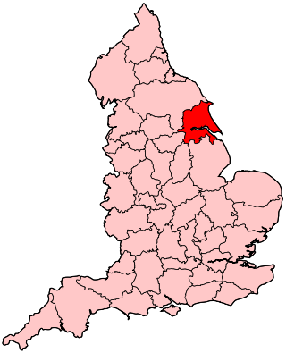
Humberside was a non-metropolitan and ceremonial county in Northern England from 1 April 1974 until 1 April 1996. It was composed of land from either side of the Humber Estuary, created from portions of the East Riding of Yorkshire, West Riding of Yorkshire, and the northern part of Lindsey, Lincolnshire. The county council's headquarters was County Hall at Beverley, inherited from East Riding County Council. Its largest settlement and only city was Kingston upon Hull. Other notable towns included Goole, Beverley, Scunthorpe, Grimsby, Cleethorpes and Bridlington. The county stretched from Wold Newton at its northern tip to a different Wold Newton at its southernmost point.

<span class="mw-page-title-main">North Riding of Yorkshire</span> Third of a historic county in England

The North Riding of Yorkshire was a subdivision of Yorkshire, England, alongside York, the East Riding and West Riding. The riding's highest point was at Mickle Fell at 2,585 ft (788 m).

<span class="mw-page-title-main">Counties of England</span> Ceremonial divisions of England

The counties of England are divisions of England. Counties have been used as administrative areas in England since Anglo-Saxon times. There are two main legal definitions of the counties in modern usage: the 84 counties for the purposes of local government, and the 48 counties for the purposes of lieutenancy, also termed the ceremonial counties.

<span class="mw-page-title-main">Parts of Lindsey</span> Historic division of Lincolnshire, England

The Parts of Lindsey are a traditional division of Lincolnshire, England, covering the northern part of the county. The Isle of Axholme, which is on the west side of the River Trent, has normally formed part of it. The district's name originated from the Kingdom of Lindsey of Anglo-Saxon times, whose territories were merged with that of Stamford to form Lincolnshire.

<span class="mw-page-title-main">Borough of Scarborough</span> Former local government district in England

The Borough of Scarborough was a non-metropolitan district with borough status in North Yorkshire, England. In addition to the town of Scarborough, it covered a large stretch of the coast of Yorkshire, including Whitby and Filey. It bordered Redcar and Cleveland to the north, the Ryedale and Hambleton districts to the west and the East Riding of Yorkshire to the south.

<span class="mw-page-title-main">Glanford</span> Former local government district in England

Glanford was, from 1974 to 1996, a local government district with borough status in the non-metropolitan county of Humberside, England.

<span class="mw-page-title-main">Local Government Act 1972</span> United Kingdom legislation

The Local Government Act 1972 is an act of the Parliament of the United Kingdom that reformed local government in England and Wales on 1 April 1974. It was one of the most significant Acts of Parliament to be passed by the Heath Government of 1970–74.

<span class="mw-page-title-main">Non-metropolitan county</span> County-level entity in England

A non-metropolitan county, or colloquially, shire county, is a subdivision of England used for local government.

<span class="mw-page-title-main">Unitary authorities of England</span> Local government in some parts of England

The unitary authorities of England are a type of local authority responsible for all local government services in an area. They combine the functions of a non-metropolitan county council and a non-metropolitan district council, which elsewhere in England provide two tiers of local government.

<span class="mw-page-title-main">Local Government Commission for England (1992)</span> United Kingdom legislation

The Local Government Commission for England was the body responsible for reviewing the structure of local government in England from 1992 to 2002. It was established under the Local Government Act 1992, replacing the Local Government Boundary Commission for England. The Commission could be ordered by the Secretary of State to undertake "structural reviews" in specified areas and recommend the creation of unitary authorities in the two-tier shire counties of England. The Commission, chaired by John Banham, conducted a review of all the non-metropolitan counties of England from 1993 to 1994, making various recommendations on their future.

The history of local government in England is one of gradual change and evolution since the Middle Ages. England has never possessed a formal written constitution, with the result that modern administration is based on precedent, and is derived from administrative powers granted to older systems, such as that of the shires.

<span class="mw-page-title-main">Cleveland (county)</span> Former county of North East England

Cleveland was a non-metropolitan county located in North East England which existed between 1974 and 1996. Cleveland was a two-tier county and had four boroughs: Hartlepool, Stockton-on-Tees, Middlesbrough and Langbaurgh-on-Tees. The county town was Middlesbrough, where Cleveland County Council met. The county was named after the historic area of Cleveland, Yorkshire. Its area is now split between the counties of North Yorkshire and County Durham.

<span class="mw-page-title-main">North Yorkshire Council</span> Unitary authority in England

North Yorkshire Council is the unitary authority which governs the non-metropolitan county of North Yorkshire, within the larger ceremonial county of North Yorkshire, in England. North Yorkshire was a two-tier non-metropolitan county from 1974 to 2023, when North Yorkshire Council was a county council called North Yorkshire County Council. On 1 April 2023 the seven lower-tier districts of the county were abolished and their functions taken over by the new unitary authority.

The East Riding of Yorkshire is a local government district with unitary authority status, and is a ceremonial county of England. It is named after the historic East Riding of Yorkshire which was one of three ridings alongside the North Riding and West Riding, which were constituent parts a Yorkshire ceremonial and administrative county until 1974. From 1974 to 1996 the area of the modern East Riding of Yorkshire constituted the northern part of Humberside.

<span class="mw-page-title-main">Combined authorities and combined county authorities</span> Type of local government institution in England

Combined authorities and combined county authorities are a type of local government institution in England.

<span class="mw-page-title-main">City of York Council</span> Council for the city of York, England

City of York Council is the local authority for York, in Yorkshire, England. York has had a city council from medieval times, which has been reformed on numerous occasions. Since 1996 the council has been a unitary authority, performing both district-level and county-level functions. It is composed of 47 councillors and has been under Labour majority control since 2023. The council is based at West Offices on Station Rise.

Structural changes to local government in England took place between 2019 and 2023. Some of these changes continue the trend of new unitary authorities being created from other types of local government districts, which was a policy of Communities Secretary Robert Jenrick from 2019.

References

  1. Vision of Britain - Yorkshire ancient county (historic map [ permanent dead link ])
  2. John Bartholomew, Gazetteer of the British Isles , (1887)
  3. 1 2 3 HMSO, Aspects of Britain: Local Government, (1996)
  4. 1 2 3 Arnold-Baker, C., Local Government Act 1972, (1973)
  5. Vision of Britain - East Riding (Ancient) Archived 15 August 2011 at the Wayback Machine (historic map [ dead link ])
  6. Vision of Britain - North Riding (Ancient) Archived 15 August 2011 at the Wayback Machine (historic map [ dead link ])
  7. Vision of Britain - West Riding (Ancient) Archived 14 August 2011 at the Wayback Machine (historic map [ dead link ])
  8. Vision of Britain - Ainsty Archived 15 August 2011 at the Wayback Machine (historic map [ dead link ])
  9. Vision of Britain - East Riding (Admin) Archived 19 April 2012 at the Wayback Machine (historic map [ dead link ])
  10. 1 2 Vision of Britain - North Riding (Admin) Archived 15 August 2011 at the Wayback Machine (historic map [ dead link ])
  11. Vision of Britain - West Riding (Admin) Archived 15 August 2011 at the Wayback Machine (historic map [ dead link ])
  12. 1971 census
  13. Elcock, H, Local Government, (1994)
  14. Redcliffe-Maud & Wood, B., English Local Government Reformed, (1974)
  15. 1 2 Jones, B. et al., Politics UK, (2004)
  16. Royal Mail, Address Management Guide, (2004)
  17. The Cleveland (Structural Change) Order 1995 Archived 2 May 2009 at the Wayback Machine SI 1995/187
  18. The Humberside (Structural Change) Order 1995 Archived 14 February 2009 at the Wayback Machine SI 1995/600
  19. "Boundary shake-up unveiled". BBC News. 1 December 2003. Retrieved 2 August 2020.
  20. "Proposals for Future Unitary Structures: Stakeholder Consultation" (PDF). Ministry of Housing, Communities & Local Government. 30 October 2008. Archived from the original (PDF) on 30 October 2008. Retrieved 2 August 2020.
  21. "County's unitary plan turned down". BBC News. 25 July 2007. Retrieved 2 August 2020.
  22. "Proposals for unitary local government in Cumbria, North Yorkshire and Somerset". GOV.UK. Ministry of Housing, Communities & Local Government. 22 February 2021.
  23. "Next steps for new unitary councils in Cumbria, North Yorkshire and Somerset". GOV.UK. Retrieved 20 December 2021.
  24. "The new council". North Yorkshire County Council . Retrieved 20 December 2021.
  25. "York and North Yorkshire devolution deal". Department for Levelling Up, Housing and Communities. 1 August 2022. Retrieved 24 October 2022.
  26. 1 2 National Statistics - 200 years of the Census in Yorkshire