Derwent derives from the Brythonic term Derventio, meaning "valley thick with oaks". It may refer to:

Howdenshire was a wapentake and a liberty of England, lying around the town of Howden in the East Riding of Yorkshire.
The Ainsty or the Ainsty of York was a historic district of Yorkshire, England west of the city of York. Originally a wapentake or subdivision of the West Riding of Yorkshire it later had a unique status as a rural area controlled by the corporation of the city.
Wressle is a village and civil parish in the East Riding of Yorkshire, England, lying on the eastern bank of the River Derwent approximately 3 miles (5 km) north-west of Howden.

Breighton is a village in the East Riding of Yorkshire, England. It is situated on the east bank of the River Derwent, approximately 5 miles (8 km) north-west of Howden.
Barlby is a linear village in North Yorkshire, England. It is situated 2 miles (3 km) to the north-east of the market town of Selby, and is bordered to the west by the River Ouse and to the east by the A19 Barlby bypass. Across the bypass is Barlby's smaller sister village, Osgodby with which it forms the civil parish of Barlby with Osgodby.

Barmby Moor is a village and civil parish in the East Riding of Yorkshire, England. It is situated approximately 1.5 miles (2.4 km) west of Pocklington. It lies north of the A1079 road where it is met by the B1246 road that passes through the village.

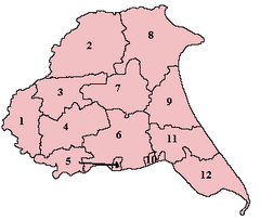
The Borough of Boothferry was, from 1 April 1974 to 1 April 1996, a local government district with borough status within the non-metropolitan county of Humberside. The district is now split between the East Riding of Yorkshire and North Lincolnshire.
Osgodby is a village in the Selby district of North Yorkshire, England, 2 miles (3.2 km) from Selby.
Derwent was a rural district in the East Riding of Yorkshire from 1935 to 1974.
Howden was a rural district in the East Riding of Yorkshire, England from 1894 to 1974.

Costa Beck is a small river in the Ryedale district of North Yorkshire, England.

Hemingbrough is a small village and civil parish in the Selby district of North Yorkshire, England that is located approximately 5 miles (8 km) from Selby and 4 miles (6.4 km) from Howden on the A63. The village has a 12th-century former collegiate church, a Methodist chapel and shops. The village also has a primary school and nursery as well as a playing field for the local children. The surrounding area makes up part of the Humberhead Levels and is flat land mainly used for mixed agriculture. It is thought that from this village came Walter of Hemingbrough, one of Britain's early chroniclers. Writing in the 14th century, he gave us a history beginning with the Norman conquest, now in the British Museum.
Fangfoss is a village in the East Riding of Yorkshire, England. It is situated approximately 11 miles (18 km) to the east of the city of York and 3.5 miles (6 km) north-west of the town of Pocklington.
Dickering was a wapentake of the historic county called East Riding of Yorkshire in England, consisting of the north-east part of that county, including the towns of Bridlington and Filey; its territory is now partly in the modern East Riding and partly in North Yorkshire. Established in medieval times, it ceased to have much significance in the 19th century when the wapentakes were superseded by other administrative divisions for most local government purposes.

Cliffe is a small village and civil parish in the Selby district of North Yorkshire, England. Until 1974 it was in the East Riding of Yorkshire.
Holderness was a wapentake of the historic East Riding of Yorkshire, England consisting of the south-easterly part of the county. Established in medieval times, it ceased to have much significance in the 19th century when the wapentakes were superseded by other administrative divisions for most local government purposes.
Harthill was a wapentake of the historic East Riding of Yorkshire, England consisting of the central part of the county. Established in medieval times, it ceased to have much significance in the 19th century when the wapentakes were superseded by other administrative divisions for most local government purposes.

Menthorpe is a hamlet in the civil parish of North Duffield in North Yorkshire, England. It lies on the west bank of the River Derwent, 6 miles (10 km) east of Selby.

Naburn Hospital was a mental health facility in Naburn, North Yorkshire, England.