
The East Riding of Yorkshire, or simply East Riding or East Yorkshire, is a ceremonial county in Northern England. It borders North Yorkshire to the north and west and North Lincolnshire to the south. It is also a non-metropolitan county for local government purposes. The coastal towns of Bridlington and Hornsea are popular with tourists from inland areas, and the port city of Kingston upon Hull is an economic, transport and tourism centre which also receives much sea freight from around the world. The current East Riding of Yorkshire came into existence in 1996 after the abolition of the County of Humberside. The county's administration is in the ancient market town of Beverley. The landscape is mainly rural, consisting of rolling hills, valleys and flat plains with many small villages and some towns scattered amid the Yorkshire Wolds. Major settlements include Kingston upon Hull, Beverley, Bridlington and Goole. At the 2011 United Kingdom census, its population was 334,179.
Allertonshire or Allerton was a wapentake and liberty in the North Riding of Yorkshire, England.

Haltemprice and Howden is a constituency in the East Riding of Yorkshire represented in the House of Commons of the UK Parliament since 1997 by David Davis, a Conservative who was also Secretary of State for Exiting the European Union until his resignation from that role on 8 July 2018.

Howden is a market and minster town and civil parish in the East Riding of Yorkshire, England. It lies in the Vale of York to the north of the M62, on the A614 road about 16 miles (26 km) south-east of York and 3 miles (4.8 km) north of Goole, which lies across the River Ouse.

Eastrington is a small village and civil parish in the East Riding of Yorkshire, England. It is situated approximately 3 miles (5 km) to the east of Howden and 17 miles (27 km) south east of York.

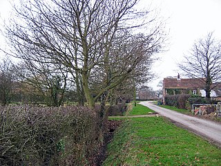
Asselby is a village and civil parish in the East Riding of Yorkshire, England. It is located in the south-west of the county, north of the River Ouse. It is situated approximately 2 miles (3.2 km) west of the market town of Howden. The land surrounding Asselby is very flat and intersected by dykes which drain into the Rivers Derwent and Ouse.
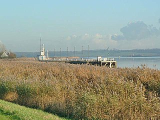
Blacktoft is a village and civil parish in the East Riding of Yorkshire, England. The village is situated on the north bank of the River Ouse, 1 mile (1.6 km) west from where it joins the River Trent and becomes the Humber. It is approximately 6 miles (10 km) east from Howden and 23 miles (37 km) south-east from the county town of York. Blacktoft lies within the Parliamentary constituency of Haltemprice and Howden an area that mainly consists of middle class suburbs, towns and villages. The area is affluent, placed as the 10th most affluent in the country in a 2003 Barclays Private Clients survey, and has one of the highest proportions of owner-occupiers in the country.

Holme is a small village and civil parish in the Hambleton District of North Yorkshire, England. It is located near Pickhill, Sinderby and Ainderby Quernhow, on the west bank of the River Swale. The population of the civil parish was estimated at 60 in 2014.

Sessay is a small, linear village and civil parish in North Yorkshire, England. It is situated approximately 4 miles (6 km) south-east from Thirsk, and 2 miles (3 km) west from the A19 road close to the East Coast Main Line.

Yokefleet is a hamlet in the East Riding of Yorkshire, England. It forms part of the civil parish of Blacktoft and a very small part of the civil parish of Laxton. It is situated on the north bank of the River Ouse, downstream from York, Selby and Goole.

Newsholme is a hamlet in the East Riding of Yorkshire, England. It is situated approximately 2 miles (3.2 km) north-west of the market town of Howden and lies on the north side of the A63 road.

Newport is a village and civil parish in the East Riding of Yorkshire, England. It is approximately 7 miles (11 km) east of the market town of Howden. It lies on the B1230 road to the south of the M62 motorway and on the banks of the Market Weighton Canal.
Newland is a hamlet in the East Riding of Yorkshire, England. It is situated approximately 3 miles (5 km) east of Howden and lies north of the B1230 road and it straddles the M62 motorway. It is served by Eastrington railway station on the Hull to York Line.
Laxton is a village and civil parish in the East Riding of Yorkshire, England. The village is situated approximately 2 miles (3 km) east from Howden and 19 miles (31 km) south-east from the county town of York.
Balkholme is a hamlet in the civil parish of Kilpin and the East Riding of Yorkshire, England.

Kilpin is a village and civil parish in the East Riding of Yorkshire, England. It is situated approximately 1.5 miles (2.4 km) south-east of Howden and 18 miles (29 km) south-east from the county town of York.
Bellasize is a hamlet in the East Riding of Yorkshire, England. It is situated approximately 5 miles (8 km) east of the market town of Howden.
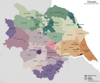
The history of local government in Yorkshire is unique and complex. Yorkshire is the largest historic English county and consists of a diverse mix of urban and rural development with a heritage in agriculture, manufacturing, and mining. After a long period with little change, it has been subject to a number of reforms of local government structures in modern times, some of which were controversial. The most significant of these were the Local Government Act 1972 and the 1990s UK local government reform. The historic area currently corresponds to several counties and districts and is mostly contained within the Yorkshire and the Humber region.
The East Riding of Yorkshire is a local government district with unitary authority status, and is a ceremonial county of England. It is named after the historic East Riding of Yorkshire which was one of three ridings alongside the North Riding and West Riding, which were constituent parts a Yorkshire ceremonial and administrative county until 1974. From 1974 to 1996 the area of the modern East Riding of Yorkshire constituted the northern part of Humberside.
