
West Yorkshire is a metropolitan and ceremonial county in the Yorkshire and the Humber region of England. West Yorkshire came into existence as a metropolitan county in 1974 after the reorganisation of the Local Government Act 1972 which saw it formed from a large part of the West Riding of Yorkshire. The county had a population of 2.3 million in the 2011 census making it the fourth-largest by population in England. The largest towns are Huddersfield, Castleford, Batley, Bingley, Pontefract, Halifax, Brighouse, Keighley, Pudsey, Morley and Dewsbury. The three cities of West Yorkshire are Bradford, Leeds and Wakefield.

Batley is a market town in the Metropolitan Borough of Kirklees, in West Yorkshire, England. Batley lies south-west of Leeds, north-west of Wakefield and Dewsbury, south-east of Bradford and north-east of Huddersfield. Batley is part of the Heavy Woollen District. In 2011 the population of Batley including Hanging Heaton, Staincliffe, Carlinghow, Birstall, Birstall Smithies, Copley Hill and Howden Clough was 48,730.

Dewsbury is a minster and market town in the Metropolitan Borough of Kirklees in West Yorkshire, England. It lies on the River Calder and on an arm of the Calder and Hebble Navigation waterway. It is to the west of Wakefield, east of Huddersfield and south of Leeds.

The West Riding of Yorkshire is one of three historic subdivisions of Yorkshire, England. From 1889 to 1974 the administrative county County of York, West Riding (the area under the control of West Riding County Council), abbreviated County of York (WR), was based closely on the historic boundaries. The lieutenancy at that time included the City of York and as such was named West Riding of the County of York and the County of the City of York.
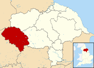
Craven was a non-metropolitan district in the west of North Yorkshire, centred on the market town of Skipton.

Tingley is a suburban village in the City of Leeds in West Yorkshire, Northern England, forming part of the parish of West Ardsley. Tingley forms part of the Heavy Woollen District. It is situated between the cities of Leeds and Wakefield.
Kildwick, or Kildwick-in-Craven, is a village and civil parish of the district of Craven in North Yorkshire, England. It is situated between Skipton and Keighley and had a population of 191 in 2001, rising slightly to 194 at the 2011 census. Kildwick is a landmark as where the major road from Keighley to Skipton crosses the River Aire. The village's amenities include a primary school, church and public house.
The Heavy Woollen District is a region of textile-focused industrial development in West Yorkshire, England. It acquired the name because of the heavyweight cloth manufactured there from the early 19th century.

East Morton is a small village which lies 2 miles (3 km) north of Bingley and 2.5 miles (4 km) east of Keighley, in the county of West Yorkshire, England. The small hamlet of West Morton lies 1 mile (1.6 km) to the north west. The village has a population of 1,169 according to the 2011 census.

Staincliffe, also known as Staincliff, was a wapentake of the West Riding of Yorkshire.

Fulneck Moravian Settlement is a village in Pudsey in the City of Leeds metropolitan borough, West Yorkshire, England. The village lies on a hillside overlooking a deep valley. Pudsey Beck flows along the bottom of the valley.

Batley Carr, West Yorkshire, England is a district partly in Dewsbury and partly in Batley, on the way to Dewsbury, along the A652, Bradford Road. Historically part of the West Riding of Yorkshire, the population is about 3,740. Crime is around the national average.

Kirkthorpe is a village within the City of Wakefield metropolitan borough of West Yorkshire, England. It lies 3 miles (4.8 km) east of the city centre.

St Dunstans railway station is a closed station in the city of Bradford, West Yorkshire, England. The station was the location of a three-way junction with platforms on two of the lines.

Harley is a hamlet in the civil parish of Wentworth, in the Rotherham district lying to the north of Rotherham and Sheffield, South Yorkshire, England.

Beggarington, also known as Beggerington and Begerington is a hamlet consisting of a few houses about 0.4 miles (0.6 km) north of Hartshead in Kirklees, West Yorkshire. It is situated in a bend of the B6119 road at the junction with the road from Roberttown. Beggerington has traditionally been considered a part of Hartshead. The place name means either "where the berries grow" or is related to beggar.

Dewsbury and District Hospital is an acute District General Hospital in Staincliffe, West Yorkshire operated by the Mid Yorkshire Teaching NHS Trust.

Hainworth is a hamlet 1 mile (2 km) south of Keighley in West Yorkshire, England. The hamlet faces north across the lower end of the Worth Valley with a steep wooded incline towards Keighley.

Ryecroft is a hamlet near to the village of Harden in West Yorkshire, England. The hamlet is on the road between Harden and Haworth, 1.9 miles (3 km) south of Keighley, 1.9 miles (3 km) west of Bingley and 0.6 miles (1 km) west of the centre of Harden.

Stone is a hamlet in the civil parish of Maltby, in the Rotherham district lying to the south of Rotherham, South Yorkshire, England. Roche Abbey stands to the west of the hamlet, with Sandbeck Park to the north.

