Ceredigion, historically Cardiganshire, is a county in the west of Wales. It borders Gwynedd across the Dyfi estuary to the north, Powys to the east, Carmarthenshire and Pembrokeshire to the south, and the Irish Sea to the west. Aberystwyth is the largest settlement and, together with Aberaeron, is an administrative centre of Ceredigion County Council.
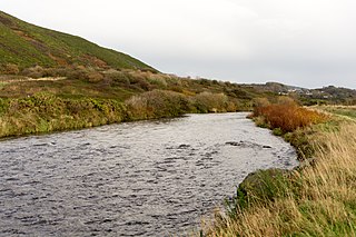
The River Ystwyth is a river in Ceredigion, Wales. The length of the main river is 20.5 miles (33.0 km). Its catchment area covers 75 square miles (190 km2). Its source is a number of streams that include the Afon Diliw, located on the west slopes of Plynlimon on the border of Ceredigion and Powys in the Cambrian Mountains. The Ystwyth flows westwards before its confluence with the Afon Rheidol and the estuary at Aberystwyth to drain into Cardigan Bay.

The Afon Rheidol is a river in Ceredigion, Wales, 19 miles (31 km) in length. The source is Plynlimon. Receiving an average annual rainfall of 40 inches (1.02 m), Plynlimon is also the source of both the Wye and the Severn.
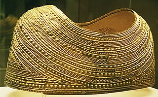
Welsh gold is gold found in natural geological deposits in two distinct areas of Wales and highly prized because of its origin and scarcity.
The Dolaucothi Gold Mines, also known as the Ogofau Gold Mine, are ancient Roman surface and underground mines located in the valley of the River Cothi, near Pumsaint, Carmarthenshire, Wales. The gold mines are located within the Dolaucothi Estate, which is owned by the National Trust.
Penparcau is a village and electoral ward in Ceredigion, Wales, situated to the south of Aberystwyth. The village has the largest number of Welsh language speakers (1095) in the Aberystwyth town area, covering an area from the sea to the Rheidol.

Mining in Wales provided a significant source of income to the economy of Wales throughout the nineteenth century and early to mid twentieth century. It was key to the Industrial Revolution in Wales, and to the whole of Great Britain.

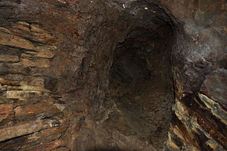
Hushing is an ancient and historic mining method using a flood or torrent of water to reveal mineral veins. The method was applied in several ways, both in prospecting for ores, and for their exploitation. Mineral veins are often hidden below soil and sub-soil, which must be stripped away to discover the ore veins. A flood of water is very effective in moving soil as well as working the ore deposits when combined with other methods such as fire-setting.

Llanfihangel-y-Creuddyn is an ancient parish in the upper division of the hundred of Ilar, Ceredigion, West Wales, 7 miles south east from Aberystwyth, on the road to Rhayader, comprising the chapelry of Eglwys Newydd, or Llanfihangel y Creuddyn Uchaf, and the township of Llanfihangel y Creuddyn Isaf. It was also known as Lower Llanfihangel y Creuddyn, Lower Llanfihangel y Croyddin and Lower Llanfihangel y Croyddyn. This parish is situated on the rivers Ystwyth, Mynach and Rheidol and intersected by various other streams. An ancient parish was a village or group of villages or hamlets and the adjacent lands. Originally they held ecclesiastical functions, but from the sixteenth century onwards they also acquired civil roles. The parish may have been established as an ecclesiastical parish. Originally a medieval administrative unit, after 1597 ecclesiastical units acquired civil functions with the Elizabethan Poor Laws, which made the parishes responsible for welfare. The civil function was exercised through vestry meetings which administered the Poor Law and were responsible for local roads and bridges.

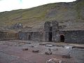
Cwmystwyth is a village in Ceredigion, Wales near Devil's Bridge, and Pont-rhyd-y-groes.
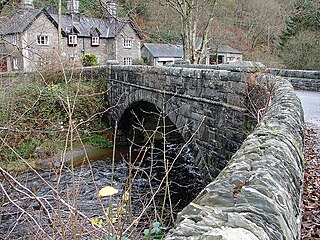
Pont-rhyd-y-groes is a village near Cwm Ystwyth and Pont ar Fynach, in Ceredigion, Wales. The village takes its name from the bridge and (earlier) ford over the River Ystwyth.

The Banc Tynddol sun-disc is a small, decorated, gold ornament discovered at Cwmystwyth, Ceredigion, Wales. It most likely was part of a funerary garment and is dated to 2450-2150 BCE, which makes it the earliest gold artifact found in Wales. It was discovered on 16 October 2002 by a team of archaeologists who were investigating the site of Roman and medieval lead smelting hearths below the Bronze Age copper mine on Copa Hill.
Mining archaeology is a specific field well-developed in the British Isles during recent decades. A reason of ongoing interest in this field is the particular bond between regional history and the exploitation of metals. References to mines in the area exist in Strabo's works. However the first accomplished study on the topic was attempted by Oliver Davies in 1935. Other momentous researches were that of geologist John S. Jackson about mines in Ireland and Lewis, Jones in Dolaucothi goldmine in Wales, and the pioneering work of Ronald F. Tylecote. Moreover, in the 1980s and 1990s a new generation of amateurs and scientists began investigations in different locations in the British Isles, including Duncan James on the Great Orme's Head, Simon Timberlake with the Early Mines Research Group at sites in Wales and William O'Brien in Ireland.

Cwmsymlog is a short valley, sheltering a hamlet of the same name, in Ceredigion, in the west of Wales. Once an important mining area, but the mining slowly declined and finally came to an end in 1901. Now it is peaceful, open countryside with a few mining remains, scattered houses and farmland. It is also the name of a Site of Special Scientific Interest at that location.

Elenydd is an upland area of Mid Wales, extending across parts of northern and eastern Ceredigion and Powys between Aberystwyth and Rhayader. Elenydd is also a name given to the medieval commote of Cwmwd Deuddwr which covered approximately the same area.

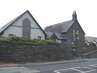
Trefeurig is a community in Mid and West Wales, situated around 4 miles (6.4 km) north-east of Aberystwyth. It is a site of particular prehistoric, Roman, and Iron Age interest, and has a long history as a mining area. In 2011 the local population was estimated at 1,771 people.
The bedrock geology of Ceredigion in west Wales consists wholly of a considerable thickness of Ordovician and Silurian age sedimentary rocks of marine origin. Unconsolidated deposits of Quaternary age include a widespread cover of glacial till, valley floor alluvium and scattered peat deposits in both upland and lowland settings.