Geology of Ceredigion

Last updated

The bedrock geology of Ceredigion (formerly Cardiganshire) in west Wales consists wholly of a considerable thickness of Ordovician and Silurian age sedimentary rocks of marine origin. [1] Unconsolidated (or 'superficial') deposits of Quaternary age include a widespread cover of glacial till, valley floor alluvium and scattered peat deposits in both upland and lowland settings.

Contents

Ordovician

The oldest rocks exposed at the surface within Ceredigion are those of Ordovician age in the southwest and in the far northeast of the county. It is the Ashgillian age Nantmel Mudstones which form the rocky coast between Gwbert and Aberporth and including Cardigan Island whilst the overlying Yr Allt Formation forms the cliffs either side of Llangrannog and including Ynys Lochtyn. Both are mudstone-dominated successions but include abundant sandstones. The Yr Allt succession extends east to Llanybydder though is less well exposed inland. Rocks of Ashgillian age are also found in the north of the county, to the northeast of Ponterwyd and to the east of Furnace where the mudstones and sandstones of the Bryn-glas, Drosgol and Nant-y-Moch formations are exposed.

Silurian

Folded and faulted Llandovery age sandstones and mudstones of the Trefechan and Mynydd Bach formations, combined as the Aberystwyth Grits Group, are exposed in the coastal cliffs southfrom Borth to Cwm Ty-du southwest of New Quay. Inland of these are the poorly exposed outcrops of the Borth Mudstones and Adail Mudstones formations reaching from the Dyfi estuary via Borth south to Lledrod then southwest to the Ystrad Aeron area. Further inland again are the mudstones and sandstones of the Devil's Bridge Formation, reaching from the northernmost parts of the county south via Devil's Bridge and southwest via Tregaron to cross into Carmarthenshire at Lampeter, with a westward extension to Talgarrog. The mudstones of the Derwenlas and Rhayader Mudstones formations, combined as the Claerwen Group occur in a band of country from the coast north of Llangrannog in a broken and wavering line east via Talgarrog to Llanybydder on the county boundary and also as an inlier at Pontrhydfendigaid, bounded to the north by a branch of the Wyre Fault running along the Ystwyth valley.

The extreme east and the southeast of the county is underlain by the sandstones and mudstones variously of the Rhuddnant Grits, Pysgotwr Grits, Dolgau Mudstones, Glanyrafon, Doethie Mudstones, Caerau Mudstones and Nant Brianne formations of Llandovery age. In the southwest from Llangrannog and Llanybydder west to Cardigan are the sandstones and mudstones of the Allt Goch Sandstone and Cwmere formations. Between Ynys Lochtyn and Cwm Ty-du the coastal cliffs are formed successively in the Cwmere and Allt Goch formations, the Claerwen Group and the sandstones and mudstones of the Erwan Fach Formation.

Geological structure

Numerous faults parallel to the gently curving coast of Cardigan Bay affect the strata. Key amongst them are the Carrog Valley, Aber Richard, Mynydd Bach, Bronnant, Teifi and Claerwen faults. Aligned at an angle to these are a prominent set of faults entering the county via Cwm Ystwyth and continuing west-southwest along the line of the Afon Wyre to the coast at Llanrhystud. It is principally on these cross-cutting lines in the northeast of Ceredigion that the mineralisation described below has taken place.

Quaternary

Ongoing coastal processes and the legacy of the ice ages provide considerable interest in the county. Of particular note too is one of Britain's finest examples of river headwater capture at Devils' Bridge. The uppermost reaches of the early Teifi were captured first by the Ystwyth and at some later time by the Rheidol leaving small 'misfit' streams in larger valleys to the south of the capture points. [2]

Glacial legacy

The county was over-run by both 'Welsh ice' and 'Irish Sea ice' during the course of the last glaciation. The former derives from cumulative snowfall on the Welsh mountains whilst much of the latter had a more distant provenance and moved onshore from Cardigan Bay. The lower courses of the Ystwyth and Rheidol are seen to be glacial in origin (or at least glacially modified) together with sections of the Aeron and Teifi valleys amongst others. Numerous glacial meltwater channels have been identified by geologists, particularly inland of both Aberystwyth and of New Quay and Llangrannog. [3] Cwm-du and Cwm Tinwen are large concave features on the south side of Cwm Ystwyth resembling glacial cirques but which are regarded as nivation cirques. [4] In the valleys of the Nant Cledlyn and Nant Cletwr are collections of ramparted depressions which have traditionally been interpreted as pingos originating through periglacial processes though alternative interpretations as lithalsas or as products of glaciation have also been proposed. [5] [6]

A prominent offshore feature which is interpreted as a glacial legacy is Sarn Gynfelyn, a shingle spit which stretches straight out from the shore at Wallog. The southernmost of three such features, they are seen to be medial moraines, left between lobes of 'Welsh ice' extending down valleys. [7]

Post-glacial deposits

Landslips are mapped in the Cardigan area and have occurred in coastal cliffs of unconsolidated sediments east of New Quay. Major valleys are typically floored by alluvium (sand, silt, gravel and pebbles) and in the Teifi valley are river terraces left as the river cut down into its earlier floodplain. Alluvial fans are frequently encountered. Peat deposits at Cors Caron near Tregaron represent the most intact raised bog in Wales and is amongst the largest such features in Britain.

Coastal deposits

Storm beaches are present along the coast at Borth and across the bays at Clarach and Aberystwyth. The remains of a submerged forest are evident at Borth, drowned by rising sea levels in the post-glacial period. A substantial area of blown sand lies behind the storm beach and inland of that is the extensive area of peatland forming the Dyfi National Nature Reserve at Ynyslas.

Economic geology

Sandstone is worked at Tylau Quarry at Lampeter, at Ystrad Meurig quarry, at Gwarallt Quarry, Talgarreg and at Bryn & Alltgoch quarries at Llanybydder. Clay and/or shale are worked at Cwar Esgair Newydd at Tresaith and at Moelfryn Maen Quarry, Bethania. Sand and gravel continue to be exploited at various sites including Penparc quarry near Cardigan, at Crug yr Eryr, Aberaeron, Glanyrafon near Aberystwyth and at Pant Quarry at Llanddewi Brefi. [8]

Metalliferous minerals

The Central Wales Orefield lies between Pontryhdfendigaid in the south and Glandyfi in the north (and extends eastwards into Powys). Within mineralised veins along various east–west aligned faults, lead has been obtained from galena whilst blende has provided zinc. Silver, manganese (in the form of psilomelane) and barium are also present. It is probable that copper and gold were being mined during the Bronze Age at Copa Hill, Cwmystwyth. Monks from Strata Florida Abbey are thought to have been involved in lead mining during Mediaeval times. [9] Most mines were operated from the late 17th through to the 19th centuries though it is likely there was also some activity during Roman times. Cwmystwyth and Ystumtuen were major mining localities, as too were Llancynfelyn, Tre-Taliesin and Tal-y-bont between Machynlleth and Aberystwyth. The remains of mines can be found scattered in the vicinity of Nant-y-moch Reservoir and also at Goginog, Cwmsymlog and Pen-bont Rhydybeddau and the Pont-rhyd-y-groes area. A mine museum (Silver Mountain Experience) is in operation near Ponterwyd. [10]

Building stone

Building stone was sourced historically in a cluster of quarries opened in the Aberystwyth Grits around Aberystwyth. Trichrug quarry north of Trefilan worked the Mynydd Bach Formation sandstones and a couple of quarries beside the river at Llandyssul exploited Ordovician sandstones for building purposes. [11]

Geoconservation

Numerous sites are protected as SSSIs whilst some RIGS are also identified and within which structured conservation activity takes place. Just under 34 km of the coastline is defined as heritage coast in recognition of the quality of its landscape which is owed principally to its geology. Underpinning the wildlife interest of the Dyfi National Nature Reserve is the assemblage of post-glacial geological features including sand dunes, mud flats and raised bog.

See also

Related Research Articles

<span class="mw-page-title-main">Ceredigion</span> County in Wales

Ceredigion, historically Cardiganshire, is a county in the west of Wales. It borders Gwynedd across the Dyfi estuary to the north, Powys to the east, Carmarthenshire and Pembrokeshire to the south, and the Irish Sea to the west. Aberystwyth is the largest settlement and, together with Aberaeron, is an administrative centre of Ceredigion County Council.

<span class="mw-page-title-main">Cardigan Bay</span> Bay in Wales

Cardigan Bay is a large inlet of the Irish Sea, indenting the west coast of Wales between Bardsey Island, Gwynedd in the north, and Strumble Head, Pembrokeshire at its southern end. It is the largest bay in Wales.

<span class="mw-page-title-main">River Teifi</span> River in Wales

The River Teifi in Wales forms the boundary for most of its length between the counties of Ceredigion and Carmarthenshire, and for the final 3 miles (4.8 km) of its total length of 76 miles (122 km), the boundary between Ceredigion and Pembrokeshire. Its estuary is northwest of Cardigan, known in Welsh as Aberteifi, meaning 'mouth of the Teifi'. Teifi has formerly been anglicised as "Tivy".

<span class="mw-page-title-main">Afon Rheidol</span> River in Ceredigion, Wales

The Afon Rheidol is a river in Ceredigion, Wales, 19 miles (31 km) in length. The source is Plynlimon. Receiving an average annual rainfall of 40 inches (1.02 m), Plynlimon is also the source of both the Wye and the Severn.

<span class="mw-page-title-main">Ceredigion Coast Path</span> Long-distance footpath following the coast of Ceredigion, Wales

The Ceredigion Coast Path is a waymarked long distance footpath in the United Kingdom, on the coast of Ceredigion, Wales. It is 65 miles (105 km) in length, running along the coast of Cardigan Bay from Cardigan (52.0810°N 4.6608°W) to Ynyslas (52.5271°N 4.0495°W).

<span class="mw-page-title-main">Afon Leri</span> River in Wales

The Afon Leri is a river in Ceredigion, Wales. It rises at Llyn Craig-y-Pistyll and is joined at Talybont by Afon Ceulan before passing behind Borth to its mouth in the Dyfi estuary at Ynyslas.

<span class="mw-page-title-main">Wallog</span> Human settlement in Wales

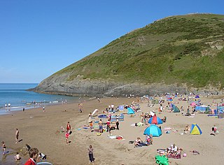
Wallog is a beach on the coast of Cardigan Bay north of Aberystwyth between Clarach Bay and Borth in the county of Ceredigion, Mid-Wales.

The geology of Monmouthshire in southeast Wales largely consists of a thick series of sedimentary rocks of different types originating in the Silurian, Devonian, Carboniferous, Triassic and Jurassic periods.

<span class="mw-page-title-main">Elenydd</span> Area of Mid Wales

Elenydd is an upland area of Mid Wales, extending across parts of northern and eastern Ceredigion and Powys between Aberystwyth and Rhayader. Elenydd is also a name given to the medieval commote of Cwmwd Deuddwr which covered approximately the same area.

The Cwmystwyth Grits Group is a Silurian lithostratigraphic group in mid Wales. The name is derived from the village of Cwmystwyth near Devil's Bridge in Ceredigion. The Group comprises the Blaen Myherin Mudstones Formation, the Glanyrafon Formation, the Caerau Mudstones Formation, the Rhuddnant Grits Formation and the Pysgotwr Grits Formation.

<span class="mw-page-title-main">Aberystwyth Grits Group</span> Geological group in Mid Wales

The Aberystwyth Grits Group is a Silurian lithostratigraphic group in mid Wales. The name is derived from Aberystwyth in northern Ceredigion where the strata are well exposed in coastal cliffs. The Group comprises the Trefechan Formation and the underlying Mynydd Bach Formation. The rocks of the Aberystwyth Grits Group have also previously been known as the Aberystwyth Grits Formation

The geology of Merseyside in northwest England largely consists of a faulted sequence of Carboniferous Coal Measures rocks overlain in the west by younger Triassic and Permian age sandstones and mudstones. Glaciation during the present Quaternary Period has left widespread glacial till as well as erosional landforms. Other post-glacial superficial deposits such as river and estuarine alluvium, peat and blown sand are abundant.

This article describes the geology of the Brecon Beacons National Park in mid/south Wales. The area gained national park status in 1957 with the designated area of 1,344 km2 (519 sq mi) including mountain massifs to both the east and west of the Brecon Beacons proper. The geology of the national park consists of a thick succession of sedimentary rocks laid down from the late Ordovician through the Silurian and Devonian to the late Carboniferous period. The rock sequence most closely associated with the park is the Old Red Sandstone from which most of its mountains are formed. The older parts of the succession, in the northwest, were folded and faulted during the Caledonian orogeny. Further faulting and folding, particularly in the south of the park is associated with the Variscan orogeny.

<span class="mw-page-title-main">Geology of Snowdonia National Park</span> Overview of geology in Snowdonia, Wales

The geology of Snowdonia National Park in North Wales is dominated by sedimentary and volcanic rocks from the Cambrian and Ordovician periods with intrusions of Ordovician and Silurian age. There are Silurian and Cenozoic sedimentary rocks on the park's margins. The succession was intensely faulted and folded during the Caledonian Orogeny. The region was uplifted as the North Atlantic Ocean opened during the Cenozoic. The current mountainous landscape arises from repeated glaciations during the Quaternary period.

The bedrock geology of Carmarthenshire in west Wales consists largely of Palaeozoic age sedimentary rocks. Unconsolidated deposits of Quaternary age in Carmarthenshire include a dissected cover of glacial till, valley floor alluvium and some scattered peat deposits in both upland and lowland settings. There are extensive beach and tidal flat deposits along the Carmarthenshire coast. The exploitation of the county's mineral riches, particularly coal and limestone, was a key part of the local economy through much of the nineteenth and twentieth centuries.

<span class="mw-page-title-main">2022 Ceredigion County Council election</span> Ceredigion County Council election

The 2022 Ceredigion County Council election took place as of 5 May 2022 to elect 38 members to Ceredigion Council. On the same day, elections were held to the other 21 local authorities and to community councils in Wales as part of the 2022 Welsh local elections. The previous all-council election took place in May 2017 and future elections will take place every five years.

The geology of Pembrokeshire in Wales inevitably includes the geology of the Pembrokeshire Coast National Park which extends around the larger part of the county's coastline and where the majority of rock outcrops are to be seen. Pembrokeshire's bedrock geology is largely formed from a sequence of sedimentary and igneous rocks originating during the late Precambrian and the Palaeozoic era, namely the Ediacaran, Cambrian, Ordovician, Silurian, Devonian and Carboniferous periods, i.e. between 635 and 299 Ma. The older rocks in the north of the county display patterns of faulting and folding associated with the Caledonian Orogeny. On the other hand, the late Palaeozoic rocks to the south owe their fold patterns and deformation to the later Variscan Orogeny.

References

  1. British Geological Survey 1:625,000 scale geological map Bedrock Geology UK South 5th Edn. NERC 2007
  2. "Geodiversity". Cambrian Mountains Society. Retrieved 26 October 2020.
  3. Lewis, Colin A.; Richards, Andrew E. (2005). The glaciations of Wales and adjacent areas (First ed.). Herefordshire: Logaston Press. pp. 86–87. ISBN   1904396364.
  4. Davies, J.R. (1997). Geology of the country around Llanilar and Rhayader. London: British Geological Survey, NERC. pp. 224–226. ISBN   0118845101.
  5. Lewis, Colin A.; Richards, Andrew E. (2005). The glaciations of Wales and adjacent areas (Second ed.). Almeley, Herefordshire: Logaston Press. pp. 97–99. ISBN   1904396364.
  6. Neil, Ross; Brabham, Peter; Harris, Charles (2019). "The glacial origins of relict 'pingos, Wales, UK" (PDF). Annals of Glaciology. 60 (80): 138–150. Bibcode:2019AnGla..60..138R. doi:10.1017/aog.2019.40. S2CID   213489418 . Retrieved 1 November 2020.
  7. 1:50,000 series (map) England and Wales sheet 163 Aberystwyth Drift Geology. British Geological Survey. 1989.
  8. "Geoindex Onshore". Maps Portal. British Geological Survey. Retrieved 25 October 2020.
  9. Mwyngloddio metel yn Ucheldir Ceredigion / Metal Mining in Upland Ceredigion (First ed.). Llandeilo: Cambria Archaeology. 2007. pp. 8–9. ISBN   9780948262081.
  10. Bick, David E. (1975). The Old Metal Mines of Mid-Wales, Part 1 Cardiganshire - South of Devil's Bridge (First ed.). Newent, Gloucs: The Pound House. pp. 10–12. ISBN   0950204013.
  11. "Geoindex Onshore". Maps Portal. British Geological Survey. Retrieved 25 October 2020.