Related Research Articles

Neath Port Talbot is a county borough in the south-west of Wales. Its principal towns are Neath, Port Talbot, Briton Ferry and Pontardawe. The county borough borders Bridgend County Borough and Rhondda Cynon Taf to the east, Powys and Carmarthenshire to the north; and Swansea to the west.

West Glamorgan is a former administrative county in South Wales. It is now a preserved county.

Ystradgynlais is a town on the River Tawe in southwest Powys, Wales. It is the second-largest town in Powys and is in the historic county of Brecknockshire. The town has a high proportion of Welsh language-speakers. The community includes Cwmtwrch, Abercraf and Cwmgiedd, with a population of 8,092 in the 2011 census. It forms part of the Swansea Urban Area where the Ystradgynlais subdivision has a population of 10,248.
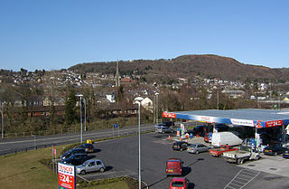
Pontardawe is a town and a community in the lower Swansea Valley. it had a population of approximately 7,172 in the 2021 Census for Pontardawe Parish, and forms part of the county borough of Neath Port Talbot.

Cwmtwrch is a village in the valley of the Afon Twrch, a right-bank tributary to the Swansea Valley, Wales, some 15 miles north of Swansea. It is also the name of an electoral ward to Powys County Council.

Neath is a constituency represented in the House of Commons of the UK Parliament since 2015 by Christina Rees, a Labour and Co-operative MP. As of 13 October 2022, she is currently suspended from the party and therefore sitting as an independent, following allegations of bullying.

The River Tawe is a 30 miles (48 km) long river in South Wales. Its headwaters flow initially east from its source below Llyn y Fan Fawr south of Moel Feity in the Black Mountains, the westernmost range of the Brecon Beacons National Park, before the river turns south and then southwest to its estuary at Swansea. Its main tributaries are the right bank Upper and Lower Clydach Rivers and the Afon Twrch. The total area of the catchment is some 246 km2 (95 sq mi). The Tawe passes through a number of towns and villages including Ystradgynlais, Ystalyfera, Pontardawe, and Clydach and meets the sea at Swansea Bay below Swansea. The Tawe Valley is more commonly known as the Swansea Valley.

The Swansea Vale Railway (SVR) was a railway line connecting the port of Swansea in South Wales to industries and coalfields along the River Tawe on the northern margin of Swansea, by taking over a tramroad in 1846. It was extended to Brynamman in 1868. Passengers were carried from 1860, and a loop line through Morriston was built.

The Swansea Canal was a canal constructed by the Swansea Canal Navigation Company between 1794 and 1798, running for 16.5 miles (26.6 km) from Swansea to Hen Neuadd, Abercraf in South Wales. It was steeply graded, and 36 locks were needed to enable it to rise 373 feet (114 m) over its length. The main cargos were coal, iron and steel, and the enterprise was profitable.

Lliw Valley was a local government district with borough status in West Glamorgan, Wales from 1974 to 1996.

Ystalyfera is a former industrial village and community in the upper Swansea Valley, on the River Tawe, about 13 miles (21 km) northeast of Swansea. It is an electoral ward and a community in the unitary authority of Neath Port Talbot, Wales, comprising a resident population of just over 3,000 people, approximately 60% of whom speak Welsh.
Neath Port Talbot College (NPTC) was a further education institution established as two campuses in Port Talbot and Neath in Wales, United Kingdom.
Alltwen is a village in the Swansea Valley in Wales. Alltwen forms part of the community of Cilybebyll and is administered separately from adjoining Pontardawe on the opposite bank of the River Tawe.

Penwyllt is a hamlet located in the upper Swansea Valley in Powys, Wales, lying within the Brecon Beacons National Park.
Trebanos is an electoral ward of Neath Port Talbot county borough, Wales, part of the Pontardawe community.
Pontardawe is the name of an electoral ward of Neath Port Talbot county borough, Wales. It is a division of the Pontardawe community and falls within the parliamentary constituency of Neath.
Godre'r Graig is a village and an electoral ward of Neath Port Talbot county borough, Wales.

Tawe-Uchaf is a community in Powys, Wales. Situated north-east of Ystradgynlais in the upper valley of the River Tawe, it includes the villages of Caehopkin, Coelbren, Glyntawe, Pen-y-cae, Penwyllt and Ynyswen. It had a population in 2001 of 1,516, increasing at the 2011 Census to 1,562.

Mynydd y Drum is a hill on the border between the county of Powys and Neath Port Talbot County Borough, south Wales. The summit of the hill is in Neath Port Talbot at 298m and lies towards the western end of a broad curving ridge, the larger part of which is in Powys. The eastern half of the hill is currently being opencasted for coal. The hill is sometimes referred to simply as The Drum.

Mynydd Allt-y-grug is a 338-metre-high hill immediately west of Ystalyfera in the county borough of Neath Port Talbot in South Wales. Its twin summits are around 400m apart. The upper part of the hill is largely covered in heather whilst conifers clothe its western slopes and gorse, bracken and bramble cover much of its rough landslide eastern side which rises above the Swansea Valley, drainage on this side flowing to the River Tawe.
References
| Authority control databases: National |
|---|
51°45′33″N3°47′23″W / 51.7593°N 3.7898°W
| | This Swansea location article is a stub. You can help Wikipedia by expanding it. |
| | This Neath Port Talbot location article is a stub. You can help Wikipedia by expanding it. |
| | This Powys location article is a stub. You can help Wikipedia by expanding it. |