Subdivisions of Wales

Last updated

The subdivisions of Wales constitute a hierarchy of administrative divisions and non-administrative ceremonial areas.

Contents

For the purposes of local government, the country is divided into principal areas, of either counties or county boroughs, and communities. The current system is the result of incremental reform which has its origins in legislation enacted in 1972 and 1994.

Administrative

Principal areas

There are 22 principal areas of Wales. They were established on 1 April 1996 by the Local Government (Wales) Act 1994 (1994 c. 19). Eleven are styled "counties", including the cities of Cardiff and Swansea, and eleven are styled "county boroughs", including the cities of Newport and Wrexham. [1] [2] [3]

The location of each council headquarters is indicated by a yellow marker. County boroughs are marked by a dagger (†).

Wales Administrative Map 2009.png
Areas marked † are county boroughs, while unmarked areas are counties. Welsh-language forms are given alongside the English where they differ.

Name changes

Five of the principal areas use different names to those given in the Local Government (Wales) Act 1994. In each case the council renamed the area immediately, with the changes taking effect on 2 April 1996. [4] The changes were:

Other smaller changes were also made, such as:

Communities

At the lowest level of administrative subdivision in Wales are the communities, into which each principal area is subdivided. They may have elected community councils which perform a number of roles, such as providing local facilities, and representing their communities to larger local government bodies. Community councils are the equivalent of English parish councils. A community council may call itself a "town council" if it so wishes. The councils of three communities with city status – Bangor, St Asaph, and St Davids – are known as "city councils". Communities which are too small to have a council may have a community meeting instead: an example of direct democracy. The communities in the urban areas of the cities of Cardiff, Swansea and Newport do not have community councils. [5] [6] [7]
Non-administrative

Preserved counties

For ceremonial purposes of Lieutenancy and Shrievalty, Wales is divided into eight preserved counties. These were based on the counties (created by the Local Government Act 1972) which were used for local government and other purposes between 1974 and 1996.

There are eight preserved counties:

Historic

Former districts

Historic counties

The historic counties of Wales are ancient subdivisions of Wales, used for various functions for several hundred years. Pembrokeshire was formed as a county palatine in 1138. In the south east, Norman advancement led to the creation of marcher lordships, such as Glamorgan, which served as semi-autonomous administrative divisions, although these were not counties in the true sense as they lacked the formal structure. Some towns within these areas did, however, receive charters which outlined rights and duties in much the same way as a borough. Counties in the strict sense first appeared with the establishment of Cardiganshire and Carmarthenshire in the 1240s. In 1284 the Principality of Gwynedd was divided into three counties: Anglesey, Caernarvonshire and Merionethshire. Before the end of the century, Flintshire had also become a county, and thus nearly half the territory of Wales was under the rule of the English Crown. While the arrangement did not officially bring the marcher lordships in the South directly under the King's control, many such lordships were held by the King personally, although some remained under the semi-autonomous control of powerful local families. The formation of counties was completed under the Laws in Wales Act 1535, which created Montgomeryshire, Denbighshire, Radnorshire, Brecknockshire and Monmouthshire, many from existing marcher lordships now recreated as counties proper.

These 13 counties were the main administrative subdivisions of Wales from 1536 until the implementation in 1974 of the Local Government Act 1972, although the definition and role of the smaller county boroughs within the counties during that period saw considerable change, as it did across the United Kingdom.

Cantrefi and Commotes

Hundreds

Regions

Regional partnership areas

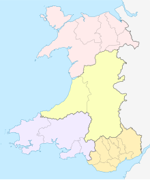
Map of the four CJCs in Wales:
.mw-parser-output .legend{page-break-inside:avoid;break-inside:avoid-column}.mw-parser-output .legend-color{display:inline-block;min-width:1.25em;height:1.25em;line-height:1.25;margin:1px 0;text-align:center;border:1px solid black;background-color:transparent;color:black}.mw-parser-output .legend-text{}
North Wales CJC
Mid Wales CJC
South West Wales CJC
South East Wales CJC Wales City Regions map.svg
Map of the four CJCs in Wales:

Wales is subdivided into four regional areas for its Corporate Joint Committees and its conterminous regional economic growth deals. City deals have been agreed for the Cardiff Capital Region and Swansea Bay City Region, which cover south-east and south-west Wales respectively, and growth deals have been agreed for Mid Wales (Growing Mid Wales) and North Wales (Ambition North Wales). There are four equivalent CJCs which may oversee the deals, and they also cover Mid Wales, North Wales, South East Wales, and South West Wales. The CJC's were established by The Local Government and Elections (Wales) Act 2021. [8] CJCs have powers relating to economic well-being, strategic planning and the development of regional transport policies. [9]

Senedd

Other subdivisions

Service areas

Police services

There are four police forces in Wales: Dyfed-Powys Police, Gwent Police, North Wales Police and South Wales Police.

  1. North Wales Police
  2. Dyfed-Powys Police
  3. South Wales Police
  4. Gwent Police

Fire and rescue services

There are three fire and rescue services in Wales, established in 1996: Mid and West Wales Fire and Rescue Service, North Wales Fire and Rescue Service and South Wales Fire and Rescue Service.

  1. North Wales Fire and Rescue Service
  2. Mid and West Wales Fire and Rescue Service
  3. South Wales Fire and Rescue Service

Health boards

There are seven local health boards in Wales.

  1. Betsi Cadwaladr University Health Board
  2. Powys Teaching Health Board
  3. Hywel Dda University Health Board
  4. Aneurin Bevan University Health Board
  5. Cwm Taf Morgannwg University Health Board
  6. Swansea Bay University Health Board
  7. Cardiff and Vale University Health Board

Trunk road agents

Trunk road agents are partnerships between two or more local authorities for the purposes of managing, maintaining, and improving the network of trunk roads (including any motorways) in their respective areas. Each trunk road agent can employ Welsh Government traffic officers. There are two agents, covering North and Mid Wales and South Wales.

Wales Trunk Road Agents map.svg

International Territorial Level

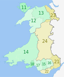
Wales is divided into statistical regions by the UK's Office for National Statistics, using the International Territorial Level geocode standard since 2021. Before Brexit, as part of the European Union and Eurostat, the system used was Nomenclature of Territorial Units for Statistics (NUTS). Wales is a level 1 ITL region alongside Scotland, Northern Ireland and the 9 statistical regions of England, with the code "TLL". It is subdivided into two ITL 2 regions, which are themselves divided into twelve ITL 3 regions.

ITL 1CodeITL 2CodeITL 3Code
WalesTLL West Wales and the Valleys TLL1 Isle of Anglesey TLL11
NUTS 3 regions of Wales map.svg Gwynedd TLL12
Conwy and Denbighshire TLL13
South West Wales (Ceredigion, Carmarthenshire, Pembrokeshire)TLL14
Central Valleys (Merthyr Tydfil, Rhondda Cynon Taff)TLL15
Gwent Valleys (Blaenau Gwent, Caerphilly, Torfaen)TLL16
Bridgend and Neath Port Talbot TLL17
Swansea TLL18
East Wales TLL2 Monmouthshire and Newport TLL21
Cardiff and Vale of Glamorgan TLL22
Flintshire and Wrexham TLL23
Powys TLL24

Electoral

Wales is divided into various electoral districts:

Settlement-based

Built-up areas

Cities

There are seven cities in total in Wales: in addition to the four principal areas with city status (Cardiff, Swansea, Newport and Wrexham), the communities of Bangor, St Davids and St Asaph also have the status. City status is granted by letters patent.

St Asaph, as the seat of a bishopric, was historically referred to as a city, and was described as such in the 1911 Encyclopædia Britannica. The status was, however, not officially recognised for many years. When city status was restored to St Davids in 1994, St Asaph town council submitted a petition for the same purpose. The petition was refused as, unlike St Davids, there was no evidence of any charter or letters patent in the past conferring the status. Applications for city status in competitions in 2000 and 2002 were unsuccessful. [10] However, city status was finally granted to St Asaph in 2012 as part of the Queen's Diamond Jubilee celebrations: [11] St Asaph was selected "to recognise its wealth of history, its cultural contribution and its metropolitan status as a centre for technology, commerce and business". Wrexham was awarded city status as part of the Queen's Platinum Jubilee in September 2022. [12] [13] [14]

See also

Related Research Articles

<span class="mw-page-title-main">Vale of Glamorgan</span> County borough in Wales

The Vale of Glamorgan, locally referred to as The Vale, is a county borough in the south-east of Wales. It borders Bridgend County Borough to the west, Cardiff to the east, Rhondda Cynon Taf to the north, and the Bristol Channel to the south. With an economy based largely on agriculture and chemicals, it is the southernmost unitary authority in Wales. Attractions include Barry Island Pleasure Park, the Barry Tourist Railway, Medieval wall paintings in St Cadoc's Church, Llancarfan, Porthkerry Park, St Donat's Castle, Cosmeston Lakes Country Park and Cosmeston Medieval Village. The largest town is Barry. Other towns include Penarth, Llantwit Major, and Cowbridge. There are many villages in the county borough.

<span class="mw-page-title-main">Glamorgan</span> Historic county of Wales

Glamorgan, or sometimes Glamorganshire, was one of the thirteen historic counties of Wales in the south of Wales. Originally an early medieval petty kingdom of varying boundaries known in Welsh as Morgannwg, which was then invaded and taken over by the Normans as the Lordship of Glamorgan. The area that became known as Glamorgan was both a rural, pastoral area, and a conflict point between the Norman lords and the Welsh princes. It was defined by a large concentration of castles.

<span class="mw-page-title-main">City status in the United Kingdom</span> Status granted by royal charter or letters patent

City status in the United Kingdom is granted by the monarch of the United Kingdom to specific centres of population, which might or might not meet the generally accepted definition of cities. As of 22 November 2022, there are 76 cities in the United Kingdom—55 in England, seven in Wales, eight in Scotland, and six in Northern Ireland. Although it carries no special rights, the status of city can be a marker of prestige and confer local pride.

Local government in Wales is primarily undertaken by the twenty-two principal councils. The councils are unitary authorities, meaning they are responsible for providing local government services within their principal area, including education, social work, environmental protection, and most highway maintenance. The principal areas are divided into communities, most of which have an elected community council. The services provided by community councils vary, but they will typically maintain public spaces and facilities. Local councils in Wales are elected; the most recent local elections in Wales took place in 2022, and the next are due to take place in 2027.

<span class="mw-page-title-main">Newport City Council</span> Local government of Newport, Wales

Newport City Council is the governing body for Newport, one of the principal areas of Wales. It consists of 51 councillors, who represent the city's 20 wards.

<span class="mw-page-title-main">Monmouthshire (historic)</span> Historic county in Wales

Monmouthshire, also formerly known as the County of Monmouth, was one of the thirteen historic counties of Wales in the south-east of Wales, on the border with England. Its area now corresponds approximately to the present principal areas of Monmouthshire, Blaenau Gwent, Newport and Torfaen, and those parts of Caerphilly and Cardiff east of the Rhymney River.

<span class="mw-page-title-main">South Glamorgan</span> Preserved county of Wales, United Kingdom

South Glamorgan is a preserved county of Wales.

<span class="mw-page-title-main">Principal areas of Wales</span> Subdivisions of Wales; counties and county boroughs

The principal areas of Wales, comprising the counties andcounty boroughs of Wales, are a form of subdivision in Wales. There are currently 22 principal areas in Wales, and they were established in 1996. They are a single-tier form of local government, each governed by a principal council. They replaced the previous two-tier system of eight counties and 37 districts that were in place in Wales from 1974 to 1996.

<span class="mw-page-title-main">Lists of places in Wales</span>

These are lists of places in Wales.

<span class="mw-page-title-main">Community (Wales)</span> Lowest tier of local government in Wales

A community is a division of land in Wales that forms the lowest tier of local government in Wales. Welsh communities are analogous to civil parishes in England but, unlike English parishes, communities cover the whole of Wales. There are 878 communities in Wales.

<span class="mw-page-title-main">Local Government (Wales) Act 1994</span> United Kingdom legislation

The Local Government (Wales) Act 1994 is an Act of the Parliament of the United Kingdom which amended the Local Government Act 1972 to create the current local government structure in Wales of 22 unitary authority areas, referred to as principal areas in the Act, and abolished the previous two-tier structure of counties and districts. It came into effect on 1 April 1996.

<span class="mw-page-title-main">Cardiff Council</span> Local government of Cardiff, Wales

Cardiff Council, formally the County Council of the City and County of Cardiff is the governing body for Cardiff, one of the principal areas of Wales. The principal area and its council were established in 1996 to replace the previous Cardiff City Council which had been a lower-tier authority within South Glamorgan. Cardiff Council consists of 79 councillors, representing 28 electoral wards.

The Local Government Commission for Wales was established by the Local Government Act 1958 to review the organisation of local government in Wales and to make recommendations for its reform. It delivered its report in 1963 and was dissolved in 1967. Its recommendations were not carried out.

The history of local government in Wales in a recognisably modern form emerged during the late 19th century. Administrative counties and county boroughs were first established in Wales in 1889. Urban and rural districts were formed in 1894. These were replaced in 1974 by a two-tier authority system across the country comprising eight counties and, within them, thirty-seven districts. This system was itself replaced by the introduction of 22 single-tier authorities in 1996.

In Wales, the office of Mayor or Lord Mayor had long been ceremonial posts, with little or no duties attached to it. Traditionally mayors have been elected by town, borough and city councils. Since 2000, councils can decide to have directly elected mayors with extensive powers if such a proposal is approved in a local referendum.

<span class="mw-page-title-main">Scouting in Wales</span>

Scouting in Wales provides an overview of Scouting activities in Wales. Scout troops have existed in the country since 1908 with the largest number of Scouts and volunteer leaders today linked to the Scout Association of the United Kingdom. This is done through ScoutsCymru, the Welsh Scout Council who split the region further into four regions and a total of 12 Scout Areas. In addition to the Scout Association, there are also traditional Scouting groups belonging to the Baden-Powell Scouts' Association and a number of Scouting clubs within Universities which are affiliated to the Student Scout and Guide Organisation.

<span class="mw-page-title-main">South Glamorgan County Council</span> Welsh local governing body (1974–1996)

South Glamorgan County Council was the local government authority that administered the county of South Glamorgan, Wales from its creation in 1974 until its abolition in 1996.

<span class="mw-page-title-main">Regions of Wales</span> Undefined class of subdivision in Wales

Wales has traditionally been divided into a number of ambiguous and ill-defined areas described as regions, reflecting historical, geographical, administrative, cultural and electoral boundaries within the country. Presently, the most common form of division of Wales into "regions" has been using cardinal and intercardinal references: north or south-west for example. None of the variously described "regions" have official status or defined boundaries; neither is there a fixed number of regions. Various organisations use different regions and combinations of regions for their individual purposes. This includes devolved institutions, such as Visit Wales, Natural Resources Wales, and the Welsh Government itself, using different sets of Wales' regions. Wales is most commonly sub-divided into between two and four regions, with a North–South divide, and North, Mid, South East and South West division being common. This article lists the various terms applied to be the "regions of Wales" and the regions used by various organisations.

References

  1. "Local Government (Wales) Act 1994". www.legislation.gov.uk. Archived from the original on 14 September 2017. Retrieved 8 May 2018.
  2. "No. 56573". The London Gazette . 21 May 2002. p. 6160.
  3. "Newport City Council". Newport City Council. 4 December 2010. Archived from the original on 9 December 2010. Retrieved 5 March 2011.
  4. "The Residuary Body for Wales (Levies) Regulations 1996". www.opsi.gov.uk. Archived from the original on 9 December 2009. Retrieved 8 May 2018.
  5. "Community councils". Cardiff Council. Archived from the original on 6 September 2018. Retrieved 7 April 2017.
  6. "Community/Town Council contact details". City and County of Swansea. 30 September 2003. Archived from the original on 8 April 2017. Retrieved 7 April 2017.
  7. "Community council contact details". Newport City Council. Archived from the original on 8 April 2017. Retrieved 7 April 2017.
  8. "Local Government and Elections (Wales) Act 2021".
  9. "The South West Wales Corporate Joint Committee Regulations 2021" (PDF).
  10. Beckett, J V (2005). City Status in the British isles, 1830 – 2002. Aldershot: Ashgate Publishing. pp. 133–135. ISBN   0-7546-5067-7.
  11. "Three towns win city status for Diamond Jubilee". BBC News. 2012-04-18. Archived from the original on 2012-04-25. Retrieved 2012-04-18.
  12. "Queen's Jubilee: Wrexham becomes Wales' seventh city". BBC News. 2022-05-20. Retrieved 2022-05-21.
  13. "The City of Wrexham: History made as city status is granted". The Leader. 20 May 2022. Retrieved 2022-05-21.
  14. "Official – Wrexham is now a city". Wrexham.com. Retrieved 2022-09-01.