Subdivisions of England

Last updated

Subdivisions of England
England Administrative Map.png
Subdivisions of England (as of 1 April 2023) that have a principal local authority: two-tier non-metropolitan counties and their non-metropolitan districts; metropolitan boroughs; unitary authorities; London boroughs; and the sui generis City of London and Isles of Scilly.
Location England
Subdivisions

The subdivisions of England constitute a hierarchy of administrative divisions and non-administrative ceremonial areas.

Contents

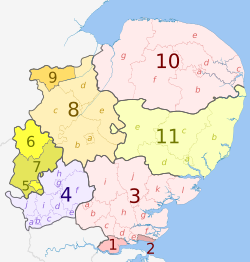
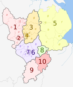
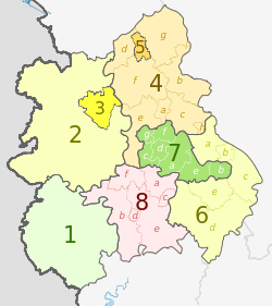
Overall, England is divided into nine regions and 48 ceremonial counties, although these have only a limited role in public policy. For the purposes of local government, the country is divided into counties, districts and parishes. In some areas, counties and districts form a two-tier administrative structure, while in others they are combined under a unitary authority. Parishes cover only part of England.

The current system is the result of incremental reform which has its origins in legislation enacted in 1965 and 1972. [1]

.mw-parser-output .legend{page-break-inside:avoid;break-inside:avoid-column}.mw-parser-output .legend-color{display:inline-block;min-width:1.25em;height:1.25em;line-height:1.25;margin:1px 0;text-align:center;border:1px solid black;background-color:transparent;color:black}.mw-parser-output .legend-text{}
metropolitan county
two-tier non-metropolitan county
unitary authority (non-metropolitan county and district)
non-metropolitan county with multiple unitary authorities (which are not counties)
Greater London
sui generis areas (City of London and Isles of Scilly)
regional boundary

ceremonial county boundary

non-metropolitan county boundary English regions and counties coloured by type map 2023.svg
   unitary authority (non-metropolitan county and district)
  non-metropolitan county with multiple unitary authorities (which are not counties)
  sui generis areas (City of London and Isles of Scilly)
  regional boundary
  ceremonial county boundary
  non-metropolitan county boundary

History

The 1974 reform of local government established the tier structure throughout England with county authorities in metropolitan and Greater London also existing, 1986 reform abolished these. From the 1996 reform the structure's use has been declining, 21 tiered areas remain out of the original 48. The county tier provides the majority of services, including education and social services while the 164 district-tier councils have a more limited role. [1]

New local administrative subdivisions in England have generally evolved through path dependence, with new units often created by merging smaller, lower-tier areas. [2]

Regional divisions

Regions

At the highest level, all of England is divided into nine regions that are each made up of a number of counties and districts. These "government office regions" were created in 1994, [3] and from the 1999 Euro-elections up until the UK's exit from the EU, they were used as the European Parliament constituencies in the United Kingdom and in England's European Parliament constituencies.[ citation needed ]

The regions vary greatly in their areas covered, populations and contributions to the national economy. [3] All have the same status, except London which has substantive devolved powers. [4]

There was a failed attempt to create elected regional assemblies outside London in 2004 and after then the structures of regional governance (regional assemblies, regional development agencies and local authority leaders' boards) have been subject to review.[ citation needed ]

Prior to the government office regions established in 1994, England was divided into eight economic planning regions. These originated in the civil defence regions established during the Second World War. [5]

List of regions

Regions of England [6]
RegionLand areaPopulation (2024)
(km2)(%)People(%)Density

(/km2)

North East 8,5812,760,678322
North West 14,1087,737,414548
Yorkshire and the Humber 15,4045,672,962368
East Midlands 15,6235,063,164324
West Midlands 12,9986,187,204476
East of England 19,1166,576,306344
London 1,5729,089,7365,782
South East 19,0729,642,942506
South West 23,8365,889,695247
England130,310100%58,620,101100%450

Combined authority areas

Outside London, the primary administrative body above the upper-tier or unitary local authority is the combined authority or combined county authority. Each combined authority covers a combined authority area, made up of the territories of each constituent council. The combined authority areas can be coterminous with another, pre-existing subdivision, such as counties. The first combined authority was the Greater Manchester Combined Authority, established in 2010, covering the ceremonial and metropolitan county of Greater Manchester. [7] Other combined authorities exist within or beyond previously existing boundaries. For example, the unitary authority area of the Borough of Halton, part of Cheshire for ceremonial purposes, joined with the metropolitan boroughs of Merseyside to form the Liverpool City Region. [8]

Counties

Counties have been a subdivision of England since they were established in the period between the 7th and 11th centuries. [9] Counties have served an administrative role since then; Parr (2020) describes them as the 'most noticeable example' of path dependence in England's local government geography. [2]

Ceremonial and historic counties

For non-administrative purposes, England is wholly divided into 48 ceremonial counties. [10] These are used for the purposes of appointing Lords Lieutenant [10] who are the Crown's representatives in those areas as well as a way of grouping non-metropolitan counties. They are taken into consideration when drawing up Parliamentary constituency boundaries.[ citation needed ] Ceremonial counties are commonly named after historic counties, the ceremonial county acts as an in between for the administrative boundaries and long established areas used in fields such as sport.

Non-metropolitan and metropolitan counties

County-tier councils and each unitary authority are separate non-metropolitan counties, each non-metropolitan county can be known as a district, city or borough. Berkshire is an anomaly in this arrangement whereby its districts became unitary authorities, the non-metropolitan county remain to keep the title of Royal county, in the same way the metropolitan county remained when the county-tier councils were abolished. [11] Each correspond to an administrative body.

Non-metropolitan districts can also be a borough, city or district. Unitary authority areas are joint non-metropolitan counties and non-metropolitan districts.

Metropolitan counties of England
CountyRegionAdministrative bodyLocal leaderLargest settlementMetropolitan boroughs
Greater Manchester North West England Greater Manchester Combined Authority Mayor of Greater Manchester Manchester [12]
Merseyside North West EnglandNone, part of Liverpool City Region Combined Authority Mayor of the Liverpool City Region Liverpool [13]
South Yorkshire Yorkshire and the Humber South Yorkshire Mayoral Combined Authority Mayor of South Yorkshire Sheffield [14]
Tyne and Wear North East EnglandNone, part of North East Combined Authority Mayor of the North East Newcastle upon Tyne [15]
West Midlands West Midlands West Midlands Combined Authority Mayor of the West Midlands Birmingham [16]
West Yorkshire Yorkshire and the Humber West Yorkshire Combined Authority Mayor of West Yorkshire Leeds [17]

List of two-tier non-metropolitan counties

Type Non-metropolitan county Non-metropolitan district
Set up19741974
No21164
Units List of districts

Sub-county divisions

Local government districts

The districts of England originate in the 1834 Poor Law reforms, which amalgamated multiple parishes to form Poor Law unions. These areas were later used as the basis for census registration districts and sanitary districts. [18] 1984 reforms to sub-county government created urban districts and rural districts as a standard lower-tier layer of local government beneath administrative counties. [2]

The 1970s local government reforms replaced the administrative counties and county boroughs with non-metropolitan counties and metropolitan counties, covering the whole of England outside of London. The lower tier of government below the non-metropolitan counties were non-metropolitan districts. [2]

Since 1992, many local authorities have been made unitary authorities, or new unitary authorities have been established to replace the previous two-tier local authorities in a particular area. This has led to either the local government district or county being, in effect, abolished. [2]

County borough

County boroughs were wholly independent urban centres that existed between 1888 and 1974. County boroughs were independent of the administrative county. [2]

Metropolitan boroughs and London

In 1986, the county-tier was abolished with the London boroughs, Metropolitan boroughs and combined boards remaining. Apart from status these boroughs have the same powers to unitary authorities.[ citation needed ]

London Boroughs and the City of London

The Greater London administrative area was created in 1965 with 32 boroughs, excluding the City of London. [19]

Type London borough Sui generis
Set up1965in antiquity
No321
Units
Total33

Miscellaneous

The Isles of Scilly are governed by a sui generis local authority called the Council of the Isles of Scilly. The authority was established in 1890 as the Isles of Scilly Rural District Council. It was renamed but otherwise unreformed by the changes in local government that occurred in 1974 in the rest of England outside Greater London. [20] Although effectively a unitary authority, for example it is an education authority, [21] the Isles of Scilly are part of the Cornwall ceremonial county and combine with Cornwall Council for services such as health [22] and economic development. [23]

The ancient City of London is the only part of Greater London not within a London borough; it is governed by the City of London Corporation, a sui generis authority unlike any other in England [19] that has largely avoided any of the reforms of local government in the 19th and 20th centuries. [24]

Civil parishes

The civil parish is the most local unit of government in England. [1] A parish is governed by a parish council or parish meeting, which exercises a limited number of functions that would otherwise be delivered by the local authority. There is one civil parish in Greater London (Queen's Park, in the City of Westminster), [25] and not all of the rest of England is parished. The number of parishes and total area parished is growing.

List of unitary authority areas

TypeSet upNoUnits
County gained district functions20232
District(s) gained county functions20232
District(s) gained county functions20212
District(s) gained county functions20201
District(s) gained county functions20192
County gained district functions20095
District(s) gained county functions20094
District(s) gained county functions199821
District(s) gained county functions199711
9
District gained county functions199613
County gained district functions19951
Sui generis18901
Total63

Hierarchical list of regions, strategic authorities, counties and districts

RegionStrategic
authority
Ceremonial
county
Metropolitan or
non-metropolitan
county
Districts
May also hold borough and/or city status
East of England
East of England counties 2019 map.svg
Essex 1.  Thurrock U.A.
2.  Southend-on-Sea U.A.
3.  Essex  a)  Harlow, b)  Epping Forest, c)  Brentwood, d)  Basildon, e)  Castle Point, f)  Rochford, g)  Maldon, h)  Chelmsford, i)  Uttlesford, j)  Braintree, k)  Colchester, l)  Tendring
4.  Hertfordshire  a)  Three Rivers, b)  Watford, c)  Hertsmere, d)  Welwyn Hatfield, e)  Broxbourne, f)  East Hertfordshire, g)  Stevenage, h)  North Hertfordshire, i)  St Albans, j)  Dacorum
Bedfordshire 5.  Luton U.A.
6.  Bedford U.A.
7.  Central Bedfordshire U.A.
Cambridgeshire and Peterborough Cambridgeshire 8.  Cambridgeshire  a)  Cambridge, b)  South Cambridgeshire, c)  Huntingdonshire, d)  Fenland, e)  East Cambridgeshire
9.  Peterborough U.A.
10.  Norfolk  a)  Norwich, b)  South Norfolk, c)  Great Yarmouth, d)  Broadland, e)  North Norfolk, f)  Breckland, g)  King's Lynn and West Norfolk
11.  Suffolk  a)  Ipswich, b) East Suffolk, c)  Babergh, d)  Mid Suffolk, e) West Suffolk
East Midlands
East Midlands counties 2021 map.svg
East Midlands Derbyshire 1.  Derbyshire  a)  High Peak, b)  Derbyshire Dales, c)  South Derbyshire, d)  Erewash, e)  Amber Valley, f)  North East Derbyshire, g)  Chesterfield, h)  Bolsover
2.  Derby U.A.
Nottinghamshire 3.  Nottinghamshire  a)  Rushcliffe, b)  Broxtowe, c)  Ashfield, d)  Gedling, e)  Newark and Sherwood, f)  Mansfield, g)  Bassetlaw
4.  Nottingham U.A.
Greater Lincolnshire
(part only)
Lincolnshire
(part only)
5.  Lincolnshire  a)  Lincoln, b)  North Kesteven, c)  South Kesteven, d)  South Holland, e)  Boston, f)  East Lindsey, g)  West Lindsey
Leicestershire 6.  Leicestershire  a)  Charnwood, b)  Melton, c)  Harborough, d)  Oadby and Wigston, e)  Blaby, f)  Hinckley and Bosworth, g)  North West Leicestershire
7.  Leicester U.A.
8.  Rutland U.A.
Northamptonshire 9.  West Northamptonshire U.A.
10.  North Northamptonshire U.A.
London
Greater London boroughs 2009 map.svg
Greater London Authority 1.  Greater London none

a)  City of Westminster, b)  Kensington and Chelsea, c)  Hammersmith and Fulham, d)  Wandsworth, e)  Lambeth, f)  Southwark, g)  Tower Hamlets, h)  Hackney, i)  Islington, j)  Camden, k)  Brent, l)  Ealing, m)  Hounslow, n)  Richmond, o)  Kingston upon Thames, p)  Merton, q)  Sutton, r)  Croydon, s)  Bromley, t)  Lewisham, u)  Greenwich, v)  Bexley, w)  Havering, x)  Barking and Dagenham, y)  Redbridge, z)  Newham, aa)  Waltham Forest, ab)  Haringey, ac)  Enfield, ad)  Barnet, ae)  Harrow, af)  Hillingdon

2.  City of London none City of London
North East
North East England counties 2009 map.svg
North East 1.  Northumberland U.A.
2.  Tyne and Wear *a)  Newcastle upon Tyne, c)  North Tyneside
b)  Gateshead, d)  South Tyneside, e)  Sunderland
Durham 3.  County Durham U.A.
Tees Valley 4.  Darlington U.A.
5.  Hartlepool U.A.
6.  Stockton-on-Tees U.A.
North Yorkshire
(part only)
7.  Redcar and Cleveland U.A.
8.  Middlesbrough U.A.
North West
North West England counties 2023 map.svg
Cumbria 1.  Cumberland U.A.
2.  Westmorland and Furness U.A
Lancashire Lancashire 3.  Lancashire  a)  West Lancashire, b)  Chorley, c)  South Ribble, d)  Fylde, e)  Preston, f)  Wyre, g)  Lancaster, h)  Ribble Valley, i)  Pendle, j)  Burnley, k)  Rossendale, l)  Hyndburn
4.  Blackpool U.A.
5.  Blackburn with Darwen U.A.
Greater Manchester 6.  Greater Manchester *a)  Bolton, b)  Bury, c)  Manchester, d)  Oldham, e)  Rochdale, f)  Salford, g)  Stockport, h)  Tameside, i)  Trafford, j)  Wigan
Liverpool City Region 7.  Merseyside  *a)  Knowsley, b)  Liverpool, c)  St. Helens, d)  Sefton, e)  Wirral
Cheshire 8.  Halton U.A.
9.  Warrington U.A.
10.  Cheshire West and Chester U.A.
11.  Cheshire East U.A.
South East
South East England counties 2020 map.svg
1.  Berkshire  a)  West Berkshire  U.A., b)  Reading  U.A., c)  Wokingham  U.A., d)  Bracknell Forest  U.A., e)  Windsor and Maidenhead  U.A., f)  Slough  U.A.
Buckinghamshire 2.  Buckinghamshire U.A.
3.  Milton Keynes U.A.
East Sussex 4. East Sussex a)  Hastings, b)  Rother, c)  Wealden, d)  Eastbourne, e)  Lewes
5.  Brighton & Hove U.A.
Kent 6.  Kent  a)  Dartford, b)  Gravesham, c)  Sevenoaks, d)  Tonbridge and Malling, e)  Tunbridge Wells, f)  Maidstone, g)  Swale, h)  Ashford, i)  Folkestone and Hythe, j)  Canterbury, k)  Dover, l)  Thanet
7.  Medway U.A.
8.  Oxfordshire  a)  Oxford, b)  Cherwell, c)  South Oxfordshire, d)  Vale of White Horse, e)  West Oxfordshire
9.  Surrey  a)  Spelthorne, b)  Runnymede, c)  Surrey Heath, d)  Woking, e)  Elmbridge, f)  Guildford, g)  Waverley, h)  Mole Valley, i)  Epsom and Ewell, j)  Reigate and Banstead, k)  Tandridge
10.  West Sussex  a)  Worthing, b)  Arun, c)  Chichester, d)  Horsham, e)  Crawley, f)  Mid Sussex, g)  Adur
Hampshire 11.  Hampshire  a)  Fareham, b)  Gosport, c)  Winchester, d)  Havant, e)  East Hampshire, f)  Hart, g)  Rushmoor, h)  Basingstoke and Deane, i)  Test Valley, j)  Eastleigh, k)  New Forest
12.  Southampton U.A.
13.  Portsmouth U.A.
14.  Isle of Wight U.A.
South West
South West England counties 2023 map.svg
Dorset 1.  Bournemouth, Christchurch and Poole U.A.
2.  Dorset U.A.
Somerset 3.  North Somerset U.A.
4.  Somerset U.A.
West of England 5.  Bath and North East Somerset U.A
6.  Bristol U.A.
Gloucestershire 7.  South Gloucestershire U.A.
8.  Gloucestershire  a)  Gloucester, b)  Tewkesbury, c)  Cheltenham, d)  Cotswold, e)  Stroud, f)  Forest of Dean
Wiltshire 9.  Swindon U.A.
10.  Wiltshire U.A.
Devon and Torbay Devon 11.  Devon  a)  Exeter, b)  East Devon, c)  Mid Devon, d)  North Devon, e)  Torridge, f)  West Devon, g)  South Hams, h)  Teignbridge
12.  Torbay U.A.
13.  Plymouth U.A.
Cornwall none14.  Isles of Scilly sui generis U.A.
15.  Cornwall U.A.
West Midlands
West Midlands counties 2009 map.svg
1.  Herefordshire U.A.
Shropshire 2.  Shropshire U.A.
3.  Telford and Wrekin U.A.
Staffordshire 4.  Staffordshire  a)  Cannock Chase, b)  East Staffordshire, c)  Lichfield, d)  Newcastle-under-Lyme, e)  South Staffordshire, f)  Stafford, g)  Staffordshire Moorlands, h)  Tamworth
5.  Stoke-on-Trent U.A.
6.  Warwickshire  a)  North Warwickshire, b)  Nuneaton and Bedworth, c)  Rugby, d)  Stratford-on-Avon, e)  Warwick
West Midlands 7.  West Midlands  *a)  Birmingham, b)  Coventry, c)  Dudley, d)  Sandwell, e)  Solihull, f)  Walsall, g)  Wolverhampton
8.  Worcestershire  a)  Bromsgrove, b)  Malvern Hills, c)  Redditch, d)  Worcester, e)  Wychavon, f)  Wyre Forest
Yorkshire and the Humber
Yorkshire and the Humber counties 2023 map.svg
South Yorkshire 1.  South Yorkshire  *a)  Sheffield, b)  Rotherham, c)  Barnsley, d)  Doncaster
West Yorkshire 2.  West Yorkshire  *a)  Wakefield, b)  Kirklees, c)  Calderdale, d)  Bradford, e)  Leeds
York and North Yorkshire North Yorkshire
(part only)
3.  North Yorkshire U.A.
4.  York U.A.
Hull and East Yorkshire East Riding of Yorkshire 5.  East Riding of Yorkshire U.A.
6.  Kingston upon Hull U.A.
Greater Lincolnshire
(part only)
Lincolnshire
(part only)
7.  North Lincolnshire U.A.
8.  North East Lincolnshire U.A.
  † Two-tier non-metropolitan county
  ‡ Royal non-metropolitan county
       (no county council)
  Unitary authority district that is not a county
  U.A. Unitary authority area (non-metropolitan county and district)
       (no county council)
   Greater London Authority

See also

Notes

  1. Metropolitan (36); non-metropolitan two-tier (164); unitary authority (62); London borough (32); sui generis (2)
  2. 1 2 3 4 5 6 7 8 9 Also a ceremonial county covering a larger area
  3. 1 2 3 4 5 6 7 8 9 10 11 12 13 14 15 16 17 18 A new district was created, merging previous districts, to form the basis of the unitary authority
  4. 1 2 3 4 5 Also a ceremonial county of identical area
  5. 1 2 merged into Bournemouth, Christchurch and Poole in 2019

References

  1. 1 2 3 Jones, B., Kavanagh, D., Moran, M. & Norton, P., Politics UK, (2004), Pearson Longman.
  2. 1 2 3 4 5 6 Parr, John (17 December 2020). "Local government in England: evolution and long-term trends". Commonwealth Journal of Local Governance: ID 7382–ID 7382. doi:10.5130/cjlg.vi23.7382. ISSN   1836-0394.
  3. 1 2 Atkinson, H. & Wilks-Heeg, S. (2000). Local Government from Thatcher to Blair. Polity.
  4. Collins, S., Colville, I & Pengelly, S., A Guide to the Greater London Authority, (2000), Sweet and Maxwell
  5. Powell, A. G. (1978). "Strategies for the English Regions: Ten Years of Evolution". The Town Planning Review. 49 (1): 5–13. ISSN   0041-0020.
  6. "Mid-Year Population Estimates, United Kingdom, June 2024". Office for National Statistics . 26 September 2025. Retrieved 26 September 2025.
  7. "John Denham – Greater Manchester to be country's first ever Combined Authority". The National Archives. The Department of Communities and Local Government. 31 March 2010. Archived from the original on 4 May 2010. Retrieved 15 November 2015. Historic plans for the country's first ever Combined Authority covering the whole of Greater Manchester to drive locally the region's economic growth were launched by Communities Secretary John Denham today.
  8. "Merseyside Councils and Halton 'agree' devolution deal". BBC News. 9 November 2015. Retrieved 29 December 2025.
  9. Aspects of Britain: Local Government. Her Majesty's Stationery Office. 1996.
  10. 1 2 "Lieutenancies Act 1997". Office of Public Sector Information. 1997. Retrieved 8 August 2010.
  11. "The Berkshire (Structural Change) Order 1996". National Archives(legislation.gov.uk). 1996. Retrieved 13 September 2012.
  12. "Greater Manchester (Metropolitan County, North West England, United Kingdom) - Population Statistics and Location in Maps and Charts". www.citypopulation.de. Retrieved 10 November 2016.
  13. "Greater Manchester (Metropolitan County, North West England, United Kingdom) - Population Statistics and Location in Maps and Charts". www.citypopulation.de. Retrieved 10 November 2016.
  14. "Greater Manchester (Metropolitan County, North West England, United Kingdom) - Population Statistics and Location in Maps and Charts". www.citypopulation.de. Retrieved 10 November 2016.
  15. "Greater Manchester (Metropolitan County, North West England, United Kingdom) - Population Statistics and Location in Maps and Charts". www.citypopulation.de. Retrieved 10 November 2016.
  16. "Greater Manchester (Metropolitan County, North West England, United Kingdom) - Population Statistics and Location in Maps and Charts". www.citypopulation.de. Retrieved 10 November 2016.
  17. "Greater Manchester (Metropolitan County, North West England, United Kingdom) - Population Statistics and Location in Maps and Charts". www.citypopulation.de. Retrieved 10 November 2016.
  18. Winstanley, Michael (n.d.). "The Poor Law in Cumbria" (PDF). Cumbria County History Trust. Cumbria County History Trust. Retrieved 29 December 2025.
  19. 1 2 Travers, T., The Politics of London, (2004), Palgrave
  20. "Local Government Act 1972". Office of Public Sector Information. 1972. Retrieved 9 August 2010.
  21. "Education and Learning". Council of the Isles of Scilly. Archived from the original on 4 June 2009. Retrieved 9 August 2010.
  22. "About Us". Cornwall and Isles of Scilly Primary Care Trust. Retrieved 9 August 2010.
  23. "The Cornwall and Isles of Scilly Enterprise Partnership". Cornwall Council. 30 July 2010. Retrieved 9 August 2010.
  24. Hebbert, Michael (1998). London: More by fortune than design. John Wiley & Sons.
  25. "Queen's Park parish council gets go-ahead". BBC News London. 29 May 2012. Retrieved 2 August 2014.