The Northern Crusades or Baltic Crusades were Christian colonization and Christianization campaigns undertaken by Catholic Christian military orders and kingdoms, primarily against the pagan Baltic, Finnic and West Slavic peoples around the southern and eastern shores of the Baltic Sea, and to a lesser extent also against Orthodox Christian Slavs.

Saaremaa is the largest island in Estonia, measuring 2,673 km2 (1,032 sq mi). The main island of Saare County, it is located in the Baltic Sea, south of Hiiumaa island and west of Muhu island, and belongs to the West Estonian Archipelago. The capital of the island is Kuressaare, which in January 2018 had 13,276 inhabitants. The whole island had a recorded population in January 2020 of 31,435.

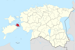
Saare County is one of 15 counties of Estonia. It consists of Saaremaa, the largest island of Estonia, and several smaller islands near it, most notably Muhu, Ruhnu, Abruka and Vilsandi. The county borders Lääne County to the east, Hiiu County to the north, and Latvia to the south. In January 2013 Saare County had a population of 30,966, which was 2.4% of the population of Estonia.

Lääne County is one of 15 counties of Estonia. It is located in western Estonia and borders the Baltic Sea to the north, Harju County to the north-east, Rapla County to the east, Pärnu County to the south, and the island counties of Saare and Hiiu to the west. In January 2009 Lääne County had a population of 23,810 – constituting 2.0% of the total population in Estonia.
Muhu, is an island in the West Estonian archipelago of the Baltic Sea. With an area of 198 km2 (76 sq mi) it is the third largest island belonging to Estonia, after Saaremaa and Hiiumaa.
Taara is a prominent god in Estonian mythology, with a strong resemblance to the Finnish Ukko and the Germanic Thor.

Ugandi was an independent county between the east coast of Lake Võrtsjärv and west coast of Lake Pskov, bordered by Vaiga, Mõhu, Nurmekund, Sakala, Tālava, and The Principality of Pskov. Ugandi had an area of approximately 3000 hides. Ugandi corresponded roughly to the present Estonia's territory of Võru County, Põlva County and half of Tartu County and Valga County, as well as Petseri County.

Saint George's Night Uprising in 1343–1345 was an unsuccessful attempt by the indigenous Estonian population in the Duchy of Estonia, the Bishopric of Ösel-Wiek, and the insular territories of the State of the Teutonic Order to rid themselves of Danish and German rulers and landlords who had conquered the country in the 13th century during the Livonian Crusade; and to eradicate the non-indigenous Christian religion. After initial success the revolt was ended by the invasion of the Teutonic Order. In 1346, the Duchy of Estonia was sold for 19,000 Köln marks by the King of Denmark to the Teutonic Order. The shift of sovereignty from Denmark to the State of the Teutonic Order took place on November 1, 1346.

Valjala Parish was a rural municipality in western Estonia. It is a part of Saare County. The municipality had a population of 1,397 and covered an area of 180.02 km².
Saint Martin's Church of Valjala is a Lutheran church in Valjala, on the island of Saaremaa, Estonia. It is the oldest stone church on Saaremaa and possibly the oldest surviving church in Estonia.

Oeselians, a term historically applied before the Northern Crusades up to the 13th century, to people, who were living on the island of Saaremaa or Oesel as it was known back then, an island in Estonia in the Baltic Sea. In modern times they are sometimes also referred to as piratical Saarlased. In Viking-Age literature, the inhabitants were often included under the name "Vikings from Estonia". The name Oeselians was first used in writing by Henry of Livonia in the 13th century. The inhabitants are often mentioned in the historic written sources during the Estonian Viking Age.

The Livonian crusade refers to the various military Christianisation campaigns in medieval Livonia – in what is now Latvia and Estonia – during the Papal-sanctioned Northern Crusades in the 12-13th century. The Livonian crusade was conducted mostly by the Holy Roman Empire and the Kingdom of Denmark. It ended with the creation of Terra Mariana and the Danish duchy of Estonia. The lands on the eastern shores of the Baltic Sea were one of the last parts of Europe to be Christianised.
Ancient Estonia refers to a period covering History of Estonia from the middle of the 8th millennium BC until the conquest and subjugation of the local Finnic tribes in the first quarter of the 13th century during the Teutonic and Danish Northern Crusades.
Baltic Noble Corporations of Courland, Livonia, Estonia, and Oesel (Ösel) were medieval fiefdoms formed by German nobles in the 13th century under vassalage to the Teutonic Knights and Denmark in modern Latvia and Estonia. The territories continued to have semi-autonomous status from 16th to early 20th century under Swedish and Russian rule.

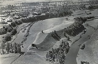
The Varbola Stronghold was the largest circular rampart fortress and trading centre built in Estonia, in Harju County in the 10th – 12th centuries. Parts of the ruins of the 580-metre (1,900 ft) long and 8-to-10-metre high limestone wall of the fortress stand to this day. The long gateways with multiple gates were built to defend the entrances. In these sections higher defensive towers were erected. There was a 13-metre (43 ft) deep well in the middle of the fortress and the territory held about 90 structures with furnaces for accommodation built with limestone floors and foundations.

The name of Estonia has complicated origins. It has been connected to Aesti, first mentioned by Tacitus around AD 98. The name's modern geographical meaning comes from Eistland, Estia and Hestia in the medieval Scandinavian sources. Estonians adopted it as endonym in the mid-19th century, previously referring themselves generally as maarahvas, meaning "land people" or "country folk".
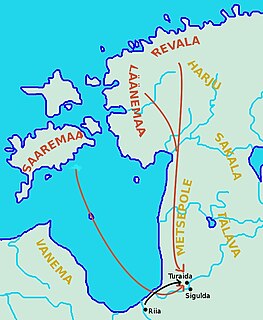
Battle of Turaida was one of the biggest battles of Livonian crusade between Estonian tribes and Livonian Brothers of the Sword. The battle took place around modern Turaida, Latvia.

The Battle of Muhu was a military engagement fought between a force of Baltic and Germanic crusaders and pagan Oeselians. The battle, fought in Muhu, Estonia, resulted in the crusaders storming and capturing a fortress held by the Oeselians.
The Viking Age in Estonia was a period in the history of Estonia, part of the Viking Age. It was not a unified country at the time, and the area of Ancient Estonia was divided among loosely allied regions. It was preceded by the Bronze and Early Iron Ages in Estonia, during which an agrarian society had developed, the Migration Period, and Pre-Viking Age with the Viking Age itself lasting between 800–1050 AD. It is often considered to be part of the Iron Age period which started around 400 AD and ended around 1200 AD, soon after Estonian Vikings were recorded in the Eric Chronicle to have sacked Sigtuna in 1187.


