
Rhyd-ddu is a small village in Snowdonia, North Wales which is a starting point for walks up Snowdon, Moel Hebog, Yr Aran and the Nantlle Ridge.
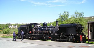
Waunfawr is a station on the narrow gauge Welsh Highland Railway, which was built in 1877 as the North Wales Narrow Gauge Railways Moel Tryfan Undertaking, to carry dressed slate to Dinas Junction on the London and North Western Railway. Passenger services ceased on 26 September 1936 and the station was reopened on 7 August 2000 following the reconstruction of the railway from Dinas to Waunfawr. The train services are operated by the Festiniog Railway Company.

Rhydlafar is a small settlement in Wales located on the outskirts of Cardiff being around 5 miles west of the city centre and 5 miles south-east of Llantrisant. The village falls within the community and ward of Creigiau & St Fagans. It was formerly the site of the specialist Prince of Wales Orthopaedic Hospital, and the settlement essentially comprises a recent housing estate development built over the former hospital.

Penygroes is a village in Gwynedd, Wales. The village is located to the south of Caernarfon, and north of Porthmadog, by the A487 road. Penygroes' population stands at 1,793 at the 2011 census, of which 88% are Welsh-speaking, making it one of the most predominantly Welsh-speaking areas of the country. The population of Llanllyfni community, which includes Penygroes and Llanllyfni village, which practically adjoins Penygroes, plus Talysarn, is 4,135 according to the 2011 census.

The A4085 is a 20-mile road between Caernarfon and Penrhyndeudraeth in North Wales that runs through the scenic Aberglaslyn Pass. There are several locations where the road is of substandard width.

Llanddulas is a village in Conwy county borough, Wales, midway between Old Colwyn and Abergele and next to the North Wales Expressway in the community of Llanddulas and Rhyd-y-Foel. The village lies beneath the limestone hill of Cefn-yr-Ogof (670 ft). This hill has large caves, and quarrying of limestone was formerly the main industry of the village, with crushed stone being exported from the 200 m long jetty.

Bow Street is a large village in the Tirymynach district of Ceredigion, Wales, approximately 3.5 miles (5.6 km) north-east of Aberystwyth. As well as Bow Street itself, it is now often considered to include the neighbouring smaller village of Pen-y-garn and the hamlet of Rhydypennau. All three places stretch in a long narrow strip along the main Aberystwyth to Machynlleth road, the A487.

Rhydypennau is a hamlet in the Genau'r-glyn district of Ceredigion, Wales, approximately 4+1⁄2 miles (7.2 km) north-east of Aberystwyth. Along with the village of Pen-y-garn, Rhydypennau is now often considered to be part of the neighbouring village of Bow Street. All three places stretch in a long narrow strip along the main Aberystwyth to Machynlleth road (A487).

Rhyd is a small village in the Welsh County of Gwynedd, located on the B4410 road, halfway between Maentwrog and Llanfrothen. Situated on an elevated site within the Snowdonia National Park, the village has views of the Moelwyns, notably Moelwyn Bach. The village is located one mile from Tan-y-Bwlch railway station, one of the principal stops on the historic Ffestiniog Railway. Nearby is Llyn Mair.
Pont-rhyd-y-groes is a village near Cwm Ystwyth and Pont ar Fynach, in Ceredigion, Wales. The village takes its name from the bridge and (earlier) ford over the River Ystwyth.

The Afon Sawdde is a river in the county of Carmarthenshire, Wales. For most of its course it flows through the Brecon Beacons National Park and Fforest Fawr Geopark.

Trelawnyd is a village in Flintshire, Wales. The village had a population taken at the 2011 census of 584. It is part of the community of Trelawnyd and Gwaenysgor.

Rhydyclafdy is a small village close to the southern coast of the Llŷn Peninsula in the Welsh county of Gwynedd. It lies 2.8 miles (4.58 km) to the west of Pwllheli and 19.65 miles (31.62 km) south west of Caernarfon. The village forms part of the community of Buan along with Boduan, and together they have a population of 469.

Rhun ap Iorwerth is a Welsh journalist and politician serving as the Leader of Plaid Cymru since 2023. He has been the Member of the Senedd (MS) for Ynys Môn since 2013.
Llanycil is a community in the county of Gwynedd, Wales, near Bala, and is 99.9 miles (160.7 km) from Cardiff and 176.2 miles (283.6 km) from London. In 2011 the population of Llanycil was 416 with 80.4% of them able to speak Welsh. The community includes the small settlements of Parc, Rhyd-uchaf and Llidiardau.

Rhyd-uchaf is a hamlet in Gwynedd, Wales, approximately 2.4 miles (3.9 km) northwest of Bala and 1.4 miles (2.3 km) south of Frongoch, on an unnamed road which provides access to Arenig Fawr. The community population taken at the 2011 census was 78.
The Afon Gwyrfai is a short river in Gwynedd, Wales. For half of its length it flows through Snowdonia National Park. Exiting Llyn y Gader it flows north through the small village of Rhyd-ddu to enter the southeastern end of Llyn Cwellyn. Downstream of the lake it flows northwest past Betws Garmon, leaving the national park and continues to the southern edge of Waunfawr. It then turns slightly west to flow on to Bontnewydd beyond which it turns slightly south to enter Foryd Bay. The tidal channel within the bay flows north into the western end of the Menai Strait. Principal tributary streams include the Afon Treweunydd which contributes water from the reservoir of Llyn Ffynnon-y-gwas and from the lakes of Llyn Glas, Llyn Coch and Llyn Nadroedd in Cwm Clogwyn immediately west of the summit of Snowdon. The tidal channel of the Gwyrfai within Foryd Bay also accepts the flow of the left bank tributaries, the Afon Foryd, Afon Rhyd and Afon Carrog. The river is shadowed by the line of the Welsh Highland Railway for much of its length, and by which it is crossed four times.
The Afon Erch is a short river on the Llŷn peninsula, Gwynedd, Wales. It arises near the village of Llanaelhaearn, flowing south and southwest towards the hamlet of Llwyndyrys where it turns abruptly eastwards and curves around to the south, passing to the east of Y Ffor at Rhyd-y-gwystl. It continues towarin a SSW direction towards Abererch where despite the village name, it does not enter the sea but flows west parallel to the coast for 1 mile to Pwllheli. The Afon Rhyd-hir joins the Afon Erch within the tidal basin of Pwllheli Harbour. Its headwaters gather to the south of Llithfaen and flow south past Llannor to approach Pwllheli from the west. It is joined by the Afon Penrhos immediately west of the town, having originated around the extensive bog of Cors Geirch, a national nature reserve. Parts of the courses of each of these rivers occupy valleys that were formed by glacial meltwater. The uppermost Penrhos is a misfit stream within its valley.


