Cemaes

Last updated

Cemaes
Cemaes - geograph.org.uk - 1716941.jpg
Cemaes Harbour
Isle of Anglesey UK location map.svg
Red pog.svg
Cemaes
Location within Anglesey
Population1,357 
OS grid reference SH370933
Community
Principal area
Ceremonial county
Country Wales
Sovereign state United Kingdom
Post town CEMAES BAY
Postcode district LL67
Dialling code 01407
Police North Wales
Fire North Wales
Ambulance Welsh
UK Parliament
Senedd Cymru – Welsh Parliament
List of places
UK
Wales
Anglesey
53°24′40″N4°27′11″W / 53.411°N 4.453°W / 53.411; -4.453 Coordinates: 53°24′40″N4°27′11″W / 53.411°N 4.453°W / 53.411; -4.453

Cemaes ( Loudspeaker.svg Welsh pronunciation ) is a village on the north coast of Anglesey in Wales, sited on Cemaes Bay, an Area of Outstanding Natural Beauty which is partly owned by the National Trust. It is the most northerly village in Wales (excluding the nearby hamlet of Llanbadrig). The name Cemaes derives from the Welsh word cemais, meaning "bend or loop in a river, inlet of sea, bay". [1] In 2011 the population of Cemaes in Llanbadrig community was 1,357. The most northerly point in Wales, Ynys Badrig, is nearby.

Contents

Cemaes is a fishing port and tourist resort, and is known for its beach. It has a sheltered natural harbour that looks north to the Irish Sea and is the site of an ancient settlement. Cemaes also has a wind farm and at nearby Wylfa is a nuclear power station. The river in the village is the River Wygyr, which flows from just below Parys Mountain to the sea at Cemaes. It is joined along the way by the Afon Meddanen on Carrog Farm, Carrog. The name Wygyr is Welsh and may mean "green wood" ((g)wig + ir) [2] or perhaps 'where two rivers meet'.

Since the Victorian era the picturesque character of Cemaes and the natural beauty of the island have attracted many artists and tourists. Lloyd George used to visit here. Cemaes is located on the Anglesey Coastal Path and is popular with walkers.

The village football team, Cemaes Bay F.C., play in the Welsh Alliance League, but previously have played in the League of Wales, being the first team on Anglesey to do so.

History

The village was a commotal seat for the Prince of Wales before the invasion of Edward I in 1282–83. Dafydd ap Llywelyn, prince of Wales from 1240 to 1246, is recorded as having issued an act at Cemaes in 1238.[ citation needed ]

Between the end of the 18th and beginning of the 20th century the village was noted for producing salted herring as well as bricks from a nearby works, which was served by a narrow gauge tramway down to the sea. The pier, which was badly needed for trade and fishing, and later tourism, was damaged badly by storms in 1828 and 1889. Both times they were rebuilt and improved by local businessmen.

Throughout its history the village has had three names. The first was Castell Iorwerth ("Iorwerth's Castle") after an important Welsh prince of the time. The second name, Cemais, is similar to the modern name and refers to the meanders in the River Wygyr that are near the village[ citation needed ]. The name of the nearby Wylfa nuclear power station is linked to the village. The late 19th-century Cemaes resident David Hughes, who travelled to Liverpool and found riches in the building industry, lived for much of his life on the island. He built the village hall in 1898 and his home 'Wylfa Manor' in 1896, on the site of the current power station. It is located under the current Wylfa car park.[ citation needed ]

The village hosted several matches of the 2019 Inter Games Football Tournament, a replacement football tournament for the popular Island Games. The games were held in Gibraltar but the lack of pitches there meant Anglesey was deemed to be a better host.[ citation needed ]

Cemaes Heritage Centre

The Cemaes heritage centre Cemaes heritage centre - geograph.org.uk - 386297.jpg
The Cemaes heritage centre

The centre forms a permanent exhibition, tea room/coffee shop and a meeting and training room. It features a brand new heritage experience, in which one can learn about the bygone era of Cemaes and the parish of Llanbadrig, from Stone Age nomads, and the area's connection to the native Welsh Princes, to Cemaes' more recent maritime and industrial heritage. It retells the life stories of some of Cemaes' most interesting and most notable characters – 'Portraits of Cemaes' – and displays a permanent art collection reflecting how artists were inspired by Cemaes' landscape and rich heritage.

Llanbadrig Church

Llanbadrig Church Llanbadrig Church - geograph.org.uk - 1717072.jpg
Llanbadrig Church

Those who make the pilgrimage from Cemaes to the headland to the east, where the church stands, will be rewarded by both the history of the church and views on a clear day to the Isle of Man, the hills of the Lake District and the Mountains of Mourne in Ireland. The Welsh name Llanbadrig means "church of St Patrick". There are three churches in Wales dedicated to St Patrick, although Llanbadrig church, founded in AD 440, is probably the only one with a direct link to the patron saint of Ireland. We know that Patrick, then Bishop, was sent by Pope Celestine I to Ireland to convert the Irish to Christianity during the 5th century. Local legend insists that Patrick was shipwrecked on Ynys Badrig (Patrick's Island, which is also called Middle Mouse because of its shape). This island can be seen from the stile in the churchyard wall. He succeeded in crossing to Anglesey, landing at Rhos Badrig (Patrick's Moor) and finding refuge in Ogof Badrig (Patrick's Cave). This cave, below the churchyard, has a freshwater well, Ffynnon Badrig (Patrick's Well), but rockfalls have made the well inaccessible. Legend states that this fresh water allowed Bishop Patrick to recover from his ordeal and he founded the church in thanks to God.[ citation needed ] Opening hours are limited to 10am–5pm May to September, and a monthly service of Evensong is held at 2pm on the first Sunday of the month during summer.

Geology

The beach at Cemaes Cemaes Beach - geograph.org.uk - 1436653.jpg
The beach at Cemaes

The rocks exposed by coastal erosion in North Anglesey belong mainly to what geologists call the Mona Complex, which is among the oldest rock units seen in Wales. It underlies, and is therefore older than, the slates of the North Wales quarrying industry, but is probably not very much older in geological terms. Since the remains of fossilized remains have been found in the rocks, it does not pre-date the origins of life and is therefore probably about 600 million years old.

The locality is well known to geologists following the enthusiastic description by Edward Greenly, in his pioneering book on the geology of Anglesey dated 1919: ‘a many coloured mélange that is really indescribable, and must therefore be seen in the field to be envisaged’.[ This quote needs a citation ]

Wildlife

Cemaes has a range of wildlife from foxes and peregrine falcons to marine life. On Wylfa Head, you can see porpoises coming up for air.[ citation needed ] Cemaes harbour is a good spot for fishing, as you can catch Atlantic mackerel, flatfish, red crabs and other fish and crustaceans. Near Cemaes is Cemlyn, which hosts the only breeding Sandwich terns in Wales.[ citation needed ]

Wales in Bloom

Cemaes Bay through the hard work of local volunteers has won the 'Wales in Bloom' village category on a number of occasions, the last being 2008. [3]

Notable people

Related Research Articles

<span class="mw-page-title-main">Holyhead</span> Port town in Isle of Anglesey, Wales

Holyhead is the largest town and a community in the county of Isle of Anglesey, Wales, with a population of 13,659 at the 2011 census. Holyhead is on Holy Island, bounded by the Irish Sea to the north, and is separated from Anglesey island by the narrow Cymyran Strait and was originally connected to Anglesey via the Four Mile Bridge.

<span class="mw-page-title-main">Menai Bridge</span> Human settlement in Wales

Menai Bridge is a town and community on the Isle of Anglesey in north-west Wales. It overlooks the Menai Strait and lies by the Menai Suspension Bridge, built in 1826 by Thomas Telford, just over the water from Bangor. With a population of 3,376, it is the fifth largest town on the island. The built-up area including Llandegfan had a population of 4,958.

<span class="mw-page-title-main">Middle Mouse</span> Island off Anglesey, Wales

Middle Mouse is an uninhabited island situated 1 kilometre off the north coast of Anglesey. It is notable as the northernmost point of Wales. The island measures a maximum of 207 metres by 110 metres, with a maximum area of 3.7 acres and has a maximum altitude of 16 metres (52') above sea level. It is one of a chain of three islands off the north of Anglesey, the others being Ynys Amlwch and Maen y Bugail.

<span class="mw-page-title-main">West Mouse</span> Island near Anglesey, Wales

West Mouse is an islet lying 1.1 kilometres (0.68 mi) off the north-west coast of Anglesey, Wales. Its maximum dimensions are 92 by 82 metres, with an area of 1.2 acres (4,900 m2).

<span class="mw-page-title-main">Abergwyngregyn</span> Human settlement in Wales

Abergwyngregyn is a village and community of historical note in Gwynedd, a county and principal area in Wales. Under its historic name of Aber Garth Celyn it was the seat of Llywelyn ap Gruffudd. It lies in the historic county of Caernarfonshire.

<span class="mw-page-title-main">The Skerries, Isle of Anglesey</span> Group of rocky islets in Wales

The Skerries coming from the Old Norse word sker are a group of sparsely vegetated rocky islets (skerries), with a total area of about 17 hectares lying 3 kilometres (1.9 mi) offshore from Carmel Head at the northwest corner of Anglesey, Wales. The islands are important as a breeding site for seabirds, and they attract divers, who come to visit the numerous shipwrecks. The Skerries Lighthouse sits atop the highest point in the islands.

<span class="mw-page-title-main">Cemlyn Bay and lagoon</span> Site of Special Scientific Interest in Wales

Cemlyn Bay is a bay on the northwest coast of Anglesey, North Wales, approximately 2.5 km west of Wylfa nuclear power station, within the community of Cylch-y-Garn.

<span class="mw-page-title-main">Puffin Island (Anglesey)</span> Island in Anglesey, Wales

Puffin Island is an uninhabited island off the eastern tip of Anglesey, Wales. It was formerly known as Priestholm in English and Ynys Lannog in Welsh. A hermitage was established here around the 6th century, and there are remains of a 12th-century monastery on the island. The island is also a Special Protection Area for wildlife.

<span class="mw-page-title-main">Trearddur</span> Village and community in Anglesey, Wales

Trearddur or Trearddur Bay is a village, seaside resort and community south of Holyhead on the west coast of Holy Island off the north-west coast of Anglesey in Wales. The community includes the small settlement of Penrhosfeilw and the Refail Farm estate.

<span class="mw-page-title-main">Cemaes Bay F.C.</span> Association football club in Wales

Cemaes Bay Football Club is a football team playing in the North Wales Coast West Football League Division One. Between 1995 and 1998 the club played in the League of Wales.

Dulas Bay is a small bay on the north east coast of Anglesey, north Wales, forming the boundary between Llaneilian and Moelfre communities. The bay is bordered by three beaches.

<span class="mw-page-title-main">Anglesey Coastal Path</span>

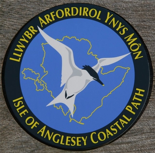
The Anglesey Coastal Path is a 200-kilometre (124 mi) long-distance footpath around the island of Anglesey in North Wales. The route is part of the Wales Coast Path.

<span class="mw-page-title-main">Llanbadrig</span> Village and community in Anglesey, Wales

Llanbadrig is a village and community in Anglesey, Wales. The parish includes the township of Clygyrog, Tregynrig and the port of Cemaes, and was formerly in the cwmwd of Talybolion. The area has extensive quarries of limestone and marble. At the 2001 census it had a population of 1,392, reducing slightly to 1,357 at the 2011 census.

<span class="mw-page-title-main">Anglesey</span> Island in Wales

Anglesey is an island off the north-west coast of Wales. It forms a principal area known as the Isle of Anglesey, that includes Holy Island across the narrow Cymyran Strait and some islets and skerries. Anglesey island, at 260 square miles (673 km2), is the largest in Wales, the seventh largest in Britain, largest in the Irish Sea and second most populous there after the Isle of Man. Isle of Anglesey County Council administers 276 square miles (715 km2), with a 2011 census population of 69,751, including 13,659 on Holy Island. The Menai Strait to the mainland is spanned by the Menai Suspension Bridge, designed by Thomas Telford in 1826, and the Britannia Bridge, built in 1850 and replaced in 1980. The largest town is Holyhead on Holy Island, whose ferry service with Ireland handles over two million passengers a year. The next largest is Llangefni, the county council seat. From 1974 to 1996 Anglesey was part of Gwynedd. Most full-time residents are habitual Welsh speakers. The Welsh name Ynys Môn is used for the UK Parliament and Senedd constituencies. The postcodes are LL58–LL78. It is also a historic county of Wales.

Tregele is a small, village located Mechell Community, in north Anglesey, Wales. Located about a mile south-west of the larger coastal village of Cemaes, it is also close to the Wylfa Nuclear Power Station now decommissioning on Wylfa Head. Despite its small size Tregele has a well stocked store and off licence incorporating a post office and petrol station A shortwalk away is the quaint and sleepy town of Cemaes Bay with its sandy beaches and very pleasant harbour. The area is ideal for walkers and bird spotters as well as those who need to relax and unwind on the coastal path while taking in breathtaking scenery and wildlife. One kilometre south of the village is a cromlech named Llanfechell Cromlech.

<span class="mw-page-title-main">Rhun ap Iorwerth</span> Welsh journalist and politician

Rhun ap Iorwerth is a Welsh journalist and politician serving as the Deputy Leader of Plaid Cymru since 2018. He has been the Member of the Senedd (MS) for Ynys Môn since 2013.

<span class="mw-page-title-main">Cemaes Head</span> Nature reserve in north Pembrokeshire

Cemaes Head is a headland and nature reserve in north Pembrokeshire. It lies in the community of St Dogmaels, within the Pembrokeshire Coast National Park. To the west and north it overlooks Cardigan Bay, and to the east Cardigan Island and the estuary of the River Teifi.

<span class="mw-page-title-main">St Padrig's Church, Llanbadrig</span> Church in Wales

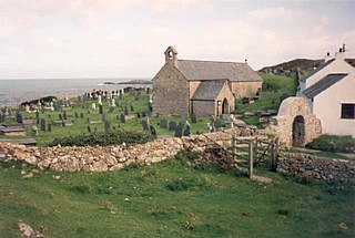
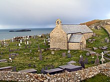
St Padrig's Church is a medieval church in the village of Llanbadrig, Anglesey, Wales. The building probably dates from the 12th century and underwent renovations in the 19th century. It was designated a Grade II* listed building on 5 December 1970.

<span class="mw-page-title-main">Coastline of Wales</span> Sea-bounded areas of Wales

The coastline of Wales extends from the English border at Chepstow westwards to Pembrokeshire then north to Anglesey and back eastwards to the English border once again near Flint. Its character is determined by multiple factors, including the local geology and geological processes active during and subsequent to the last ice age, its relative exposure to or shelter from waves, tidal variation and the history of human settlement and development which varies considerably from one place to another. The majority of the coast east of Cardiff in the south, and of Llandudno in the north, is flat whilst that to the west is more typically backed by cliffs. The cliffs are a mix of sandstones, shales and limestones, the erosion of which provides material for beach deposits. Of the twenty-two principal areas which deliver local government in Wales, sixteen have a coastline, though that of Powys consists only of a short section of tidal river some distance from the open sea. Its length has been estimated at 1,680 miles (2,700 km).

References

  1. "Dictionary of the Welsh Language | The standard historical Welsh dictionary".
  2. https://archive.org/stream/cu31924028086621/cu31924028086621_djvu.txt "The Place-Names of Wales"
  3. "Wales in Bloom". Archived from the original on 5 June 2010.