This is a list of the Sites of Special Scientific Interest (SSSIs) in the Isle of Anglesey Area of Search (AoS). [1]
This is a list of the Sites of Special Scientific Interest (SSSIs) in the Isle of Anglesey Area of Search (AoS). [1]

Ynys Llanddwyn is a small tidal island off the west coast of Anglesey, northwest Wales. The nearest settlement is the village of Newborough.

Rhosneigr is a village in the south-west of Anglesey, north Wales. It is situated on the A4080 road. It is south-east of Holyhead, and is on the Anglesey Coastal Path. From the clock at the centre of the village can be seen RAF Valley and Mynydd Twr. The towns of Holyhead and Llangefni and the city of Bangor are all within easy travelling distance.

Puffin Island is an uninhabited island off the eastern tip of Anglesey, Wales. It was formerly known as Priestholm in English. A hermitage was established here around the 6th century, and there are remains of a 12th-century monastery on the island. The island is also a Special Protection Area for wildlife.

Llyn Cerrig Bach is a small lake located between Rhosneigr and Valley in the west of Anglesey, Wales.

Ynys y Bîg is a small private island in the Menai Strait attached to the island of Anglesey, in North Wales, by a wooden bridge. The bridge runs from the grounds of a private house, itself also called Ynys y Bîg, preventing any public access. The bridge fell into disrepair but was reconstructed in 2019.

Seiriol was an early 6th-century saint, who created a cell at Penmon Priory on Anglesey, off the coast of north Wales. He later moved to Ynys Seiriol.
The Anglesey Coastal Path is a 200-kilometre (124 mi) long-distance footpath around the island of Anglesey in North Wales. The route is part of the Wales Coast Path.

The Isle of Anglesey County Council is the local authority for the Isle of Anglesey, a principal area with county status in Wales. Since 2022 the council has 35 councillors who represent 11 multi-member electoral wards.

Morfa Bychan is a village located in Gwynedd, North Wales, with a population of over 500, with an almost equal number of people born in England or Wales.

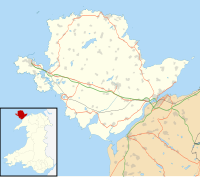
Anglesey is an island off the north-west coast of Wales. It forms the bulk of the county known as the Isle of Anglesey, which also includes Holy Island and some islets and skerries. The county borders Gwynedd across the Menai Strait to the southeast, and is otherwise surrounded by the Irish Sea. Holyhead is the largest town, and the administrative centre is Llangefni. The county is part of the preserved county of Gwynedd.
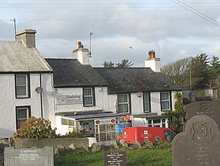
Llanfaelog is a village and community in western Anglesey, Wales. It is situated some 13 kilometres south-east of Holyhead and 22 kilometres west of the city of Bangor. At the 2001 census, it had a population of 1,679, increasing to 1,758 at the 2011 Census. The community includes Rhosneigr, Bryn Du, and Pencarnisiog. The population of the village itself is less than 400.
Glannau Rhoscolyn is a Site of Special Scientific Interest in Anglesey, North Wales, and extends along the west coast of Holy Island, Anglesey for approximately 6.5 km (4.0 mi). It has been designated as a Site of Special Scientific Interest since January 1961 in an attempt to protect its fragile biological and geological elements. The site has an area of 145.49 hectares and is managed by Natural Resources Wales.

St Gwenfaen's Well is an early medieval holy well in the south west of Holy Island, Anglesey, named after St Gwenfaen, whose cloister was nearby. The site includes substantial remains of a building and is both a scheduled monument and a Grade II listed building. Traditionally, a gift of two white quartz pebbles thrown into the pool can cure mental health problems.
The geology of Anglesey, the largest (714 km2) island in Wales is some of the most complex in the country. Anglesey has relatively low relief, the 'grain' of which runs northeast–southwest, i.e. ridge and valley features extend in that direction reflecting not only the trend of the late Precambrian and Palaeozoic age bedrock geology but also the direction in which glacial ice traversed and scoured the island during the last ice age. It was realised in the 1980s that the island is composed of multiple terranes, recognition of which is key to understanding its Precambrian and lower Palaeozoic evolution. The interpretation of the island's geological complexity has been debated amongst geologists for decades and recent research continues in that vein.
| National parks |
|  | ||
|---|---|---|---|---|
| Areas of Outstanding Natural Beauty |
| |||
| Heritage coasts | ||||
| Nature reserves | ||||
| Site of Special Scientific Interest | ||||
| European designations (–2020) | ||||
| Other designations | ||||
