
Holy Island is an island on the western side of the larger Isle of Anglesey, Wales, from which it is separated by the Cymyran Strait. It is called "Holy" because of the high concentration of standing stones, burial chambers, and other religious sites on the small island. The alternative English name of the island is Holyhead Island. According to the 2011 UK Census, the population was 13,659, of which 11,431 (84%) lived in the largest town, Holyhead.

South Stack is an island situated just off Holy Island on the northwest coast of Anglesey, Wales.
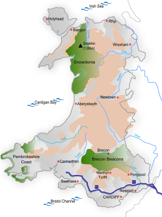
Wales is a country that is part of the United Kingdom and whose physical geography is characterised by a varied coastline and a largely upland interior. It is bordered by England to its east, the Irish Sea to its north and west, and the Bristol Channel to its south. It has a total area of 2,064,100 hectares and is about 170 mi (274 km) from north to south and at least 60 mi (97 km) wide. It comprises 8.35 percent of the land of the United Kingdom. It has a number of offshore islands, by far the largest of which is Anglesey. The mainland coastline, including Anglesey, is about 1,680 mi (2,704 km) in length. As of 2014, Wales had a population of about 3,092,000; Cardiff is the capital and largest city and is situated in the urbanised area of South East Wales.
The Skerries coming from the Old Norse word sker are a group of sparsely vegetated rocky islets (skerries), with a total area of about 17 hectares lying 3 kilometres (1.9 mi) offshore from Carmel Head at the northwest corner of Anglesey, Wales. The islands are important as a breeding site for seabirds, and they attract divers, who come to visit the numerous shipwrecks. The Skerries Lighthouse sits atop the highest point in the islands.

Rhosneigr is a village in the south-west of Anglesey, north Wales. It is situated on the A4080 road some 10 km south-east of Holyhead, and is on the Anglesey Coastal Path. From the clock at the centre of the village can be seen RAF Valley and Mynydd Twr. The major towns of Holyhead and Llangefni and the city of Bangor are all within easy travelling distance. It is the most expensive place to live in Anglesey in terms of house prices.
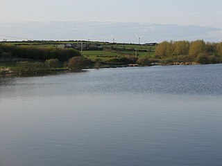
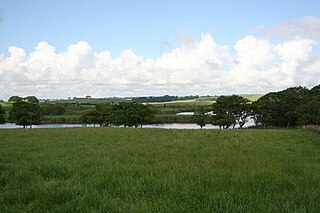
Llyn Alaw is a man-made reservoir on Anglesey, North Wales managed by Dŵr Cymru Welsh Water. It is a shallow lake and was built in 1966. It is a Site of Special Scientific Interest and a destination for over-wintering birds.
Gwydir Forest, also spelled Gwydyr, is located in Conwy county borough and the Snowdonia National Park in Wales. It takes its name from the ancient Gwydir Estate, established by the John Wynn family of Gwydir Castle, which owned this area.

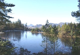
Llyn Padarn is a glacially formed lake in Snowdonia, Gwynedd, north Wales, and is an example of a moraine dammed lake. The lake is approximately 2 miles (3.2 km) long and at its deepest point is 94 feet (29 m) deep, and is one of the largest natural lakes in Wales. At its south-eastern end it is linked to the neighbouring Llyn Peris. The busy village of Llanberis lies on the southern banks of the lake.

Penrhos Country Park is a country park near Holyhead, on the island of Anglesey in Wales, United Kingdom. The park attracts approximately 100,000 visitors each year. It was opened in 1971 on the former Penrhos estate which was formerly owned by the Stanley family and at the time of opening the Anglesey Aluminium company.
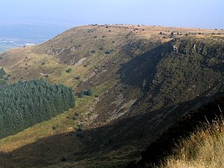
Craig y Llyn is a mountain situated to the south of the village of Rhigos in the Cynon Valley on the south side of the upper Vale of Neath and north of the Rhondda Valleys in South Wales; it is the highest point in the ancient kingdom and, later, county of Glamorgan (Morgannwg), and the southern Welsh coalfield plateau.

Rhosgoch is a small village in the north of the island of Anglesey, Wales, about 3.5 miles (5.6 km) to the south-west of Amlwch. It is in the community of Rhosybol.

Anglesey is an island off the north-west coast of Wales. It forms a principal area known as the Isle of Anglesey, that includes Holy Island across the narrow Cymyran Strait and some islets and skerries. Anglesey island, at 260 square miles (673 km2), is the largest in Wales, the seventh largest in Britain, largest in the Irish Sea and second most populous there after the Isle of Man. Isle of Anglesey County Council administers 276 square miles (715 km2), with a 2011 census population of 69,751, including 13,659 on Holy Island. The Menai Strait to the mainland is spanned by the Menai Suspension Bridge, designed by Thomas Telford in 1826, and the Britannia Bridge, built in 1850 and replaced in 1980.

Valley Wetlands, formerly Valley Lakes, is a nature reserve in Anglesey, Wales belonging to the Royal Society for the Protection of Birds. It is an area of lakes and reedbeds to the south-east of Valley in Llanfair-yn-Neubwll community, adjacent to RAF Valley airfield. The western section of the reserve includes Llyn Penrhyn, Llyn Treflesg and part of Llyn Dinam. The eastern part includes Llyn Traffwll and wetlands along the Afon Crigyll. Much of the reserve is included within two Sites of Special Scientific Interest.

Llyn Llywenan is a lake in western Anglesey, Wales found just over 1 kilometre (0.6 mi) north of the village of Bodedern and 9 kilometres (5.6 mi) east of the town of Holyhead. At a maximum length of 1.1 kilometres (0.7 mi) and breadth of 0.4 kilometres (0.2 mi) it has a surface area of only 0.4 square kilometres (0.2 sq mi). This makes it the largest natural lake on the island—both Llyn Alaw and Llyn Cefni are larger but are man made.

Wales, a country that is part of the United Kingdom, contains protected areas under various designations. The largest designation by land area is Wales' three national parks, followed by the five Areas of Outstanding Natural Beauty.

Malltraeth Marsh is a large marsh area in Anglesey, North Wales, north-east of Malltraeth village, along the flatlands of Trefdraeth, Bodorgan, Llangristiolus and south of Cefn Cwmwd, Rhostrehwfa. It was reclaimed from estuarine marshes after the construction of the Malltraeth Cob (dyke), a 1 mile (1.6 km) long embankment, and the subsequent canalisation in 1824 of the Afon Cefni.
Llanfaethlu is a village and community in the north west of Anglesey, in north-west Wales. The community population taken at the 2011 Census was 553. The village takes its name from the Church of Saint Maethlu. The community includes Llanfwrog.

Rhosybol is a village and community in Anglesey, Wales. The community population at the 2011 census was 1,078. Located 2.5 miles (4.0 km) south of the town of Amlwch, the village is close to both Llyn Alaw, the largest body of water on the island, and Parys Mountain, the site of the historic copper mines which lies just to the north. It is to the mines that the village owes its existence as it was one of several built to house the miners. During the 1960s noted painter Kyffin Williams produced an oil painting of the village.
Llanbadrig - Dinas Gynfor is a Site of Special Scientific Interest in Anglesey, North Wales. It has been designated as a Site of Special Scientific Interest since January 1957 in an attempt to protect its fragile geological elements. The site has an area of 26.49 hectares and is managed by Natural Resources Wales.
Llyn Bodgylched is a Site of Special Scientific Interest in Anglesey, North Wales, to the west of Beaumaris. It has been designated as a Site of Special Scientific Interest since January 1968 in an attempt to protect its fragile biological elements, mainly a swamp. The site has an area of 16.37 hectares and is managed by Natural Resources Wales.
