
This is a list of the Sites of Special Scientific Interest (SSSIs) in the Conwy Area of Search (AoS). [1]
This is a list of the Sites of Special Scientific Interest (SSSIs) in the Conwy Area of Search (AoS). [1]

Snowdonia, or Eryri, is a mountainous region and national park in North Wales. It contains all 15 mountains in Wales over 3000 feet high, including the country's highest, Snowdon, which is 1,085 metres (3,560 ft) tall. These peaks are all part of the Snowdon, Glyderau, and Carneddau ranges in the north of the region. The shorter Moelwynion and Moel Hebog ranges lie immediately to the south.
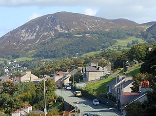
Penmaenmawr is a town and community in Conwy County Borough, Wales, which was formerly in the parish of Dwygyfylchi and the traditional county of Caernarfonshire. It is on the North Wales coast between Conwy and Llanfairfechan and was an important quarrying town, though quarrying is no longer a major employer. The population of the community was 4,353 in 2011, including Dwygyfylchi and Capelulo. The town itself having a population of 2,868 (2011).

The River Conwy is a river in north Wales. From its source to its discharge in Conwy Bay it is 55 kilometres (34 mi) long and drains an area of 678 square km. "Conwy" was formerly anglicised as "Conway."

Abergwyngregyn is a village and community of historical note in Gwynedd, a county and principal area in Wales. Under its historic name of Aber Garth Celyn it was the seat of Llywelyn ap Gruffudd. It lies in the historic county of Caernarfonshire.

Dyffryn Ogwen, or Ogwen Valley, is a valley mostly located in the Welsh county of Gwynedd. The upper section of the valley, east of Llyn Ogwen, lies in the county of Conwy.

The Afon Llyfni is a small river in North Wales which arises as Nant Drws y Coed between Mynydd Mawr and Mynydd Drws-y-Coed just to the west of Snowdon.

Llannefydd is a village and community in Conwy County Borough, in Wales. It is located on the border with Denbighshire, between the Afon Aled and River Elwy, 5.7 miles (9.2 km) north west of Denbigh, 5.8 miles (9.3 km) south west of St Asaph, 6.9 miles (11.1 km) south of Abergele and 15.2 miles (24.5 km) south east of Conwy. In the 2011 census the community parish had a population of 590. The community includes the village of Cefn Berain and part of the hamlet of Bont Newydd.
The Upper Corris Tramway was a 2 ft 3 in gauge horse-worked tramway that connected the slate quarries around the villages of Corris and Corris Uchaf with the Corris Railway at Maespoeth Junction. It was just over 1.8 miles (2.9 km) long.
| National parks |
|  | ||
|---|---|---|---|---|
| Areas of Outstanding Natural Beauty |
| |||
| Heritage coasts | ||||
| Nature reserves | ||||
| Site of Special Scientific Interest | ||||
| European designations (–2020) | ||||
| Other designations | ||||
