This is a list of towns and villages in Conwy County Borough , Wales.
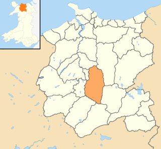
Conwy County Borough is a county borough in the north of Wales. It borders Gwynedd to the west and south and Denbighshire to the east. The largest settlement is Colwyn Bay, and Conwy is the administrative centre.
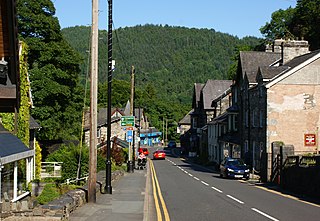
Betws-y-coed is a village and community in the Conwy valley in Conwy County Borough, Wales, located in the historic county of Caernarfonshire, right on the boundary with Denbighshire, in the Gwydir Forest. It is now a very popular visitor destination in the Snowdonia National Park.

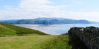
Colwyn Bay is a town, community and seaside resort in Conwy County Borough on the north coast of Wales overlooking the Irish Sea. It lies within the historic county of Denbighshire. Eight neighbouring communities are incorporated within its postal district. Established as its own separate parish in 1844 with just a small grouping of homes and farms where the community of Old Colwyn stands today, Colwyn Bay has expanded to become the second-largest community and business centre in the north of Wales as well as the 14th largest in the whole of Wales with the urban statistical area, including Old Colwyn, Rhos-on-Sea, and Mochdre and Penrhyn Bay, having a population of 34,284 at the 2011 census.

Rhos-on-Sea is a seaside resort and community in Conwy County Borough, Wales. The population was 7,593 at the 2011 census. It adjoins Colwyn Bay and is named after the Welsh kingdom of Rhos established there in late Roman Britain as a sub-kingdom of Gwynedd. It later became a cantref (hundred).

The Borough of Aberconwy was a local government district with borough status from 1974 to 1996, being one of five districts in the county of Gwynedd, north-west Wales.

The River Conwy is a river in north Wales. From its source to its discharge in Conwy Bay it is 55 kilometres (34 mi) long and drains an area of 678 square km. "Conwy" was formerly anglicised as "Conway."

Old Colwyn is a village just to the east of Colwyn Bay, in Conwy County Borough, Wales.
Betws or Bettws may refer to:
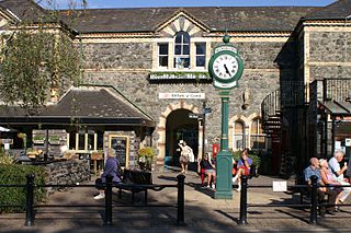
Betws-y-coed railway station is on the Conwy Valley Line, which runs between Llandudno and Blaenau Ffestiniog. It is situated 15+1⁄2 miles (24.9 km) south of Llandudno Junction.

Betws yn Rhos is a village and community in Conwy County Borough, Wales.

Tal-y-Bont is a small village in Conwy County Borough, Wales and lies in the Conwy Valley, west of the River Conwy, on the B5106 road, 6 mi (9.7 km) from the town of Conwy to the north, and six miles from Llanrwst to the south, and in the community of Caerhun. It lies adjacent to the village of Dolgarrog to the south, and below the small settlement of Llanbedr-y-Cennin to the west. The population is around 400.
The Vale of Clwyd and Conwy Football League was a football league formed in 2011 following the split of the Clwyd Football League, which itself was formed in 1974 as an amalgamation of the Dyserth and the Halkyn Mountain League. The Premier Division was in the fifth level of the Welsh football league system in North Wales. The league folded in 2020 due to a reorganisation of the Welsh football league pyramid, with many teams joining the North Wales Coast East Football League.
The LL postcode area, also known as the Llandudno postcode area, is a group of 67 postcode districts, within 62 post towns. These cover the majority of north Wales, plus a very small part of west Wales and the English county of Shropshire. The districts start at LL11 so as to avoid confusion with Liverpool postcodes.
Bro Garmon is a sparsely populated community in Conwy County Borough, in Wales. It is located on the eastern side of the Conwy Valley, stretching from north east of Llanrwst to just west of Pentrefoelas, and includes the villages of Capel Garmon, Glan Conwy, Melin-y-Coed, Nebo, Oaklands, Rhydlanfair and Pentre-tafarn-y-fedw. Moel Seisiog, on the eastern boundary, rises to a height of 1,535 feet (468 m). The main settlement, Capel Garmon, lies 2.4 miles (3.9 km) east of Betws-y-Coed, 5.2 miles (8.4 km) north west of Pentrefoelas, 4.4 miles (7.1 km) south of Llanrwst and 15.7 miles (25.3 km) south of Conwy. At the 2001 census the community had a population of 648, increasing slightly at the 2011 census to 652.
Grŵp Llandrillo Menai (GLlM) is an umbrella organisation overseeing the operation of three member colleges in North Wales: Coleg Llandrillo, Coleg Menai and Coleg Meirion-Dwyfor.

Betws-y-Coed is the name of an electoral ward in the southwest of Conwy County Borough, Wales. It covers its namesake community of Betws-y-Coed, as well as the neighbouring communities of Dolwyddelan and Capel Curig.

Conwy County Borough is a county borough in the north of Wales. It covers an area of 1,126 km2 (435 sq mi) and had a population of approximately 114,800 in 2021.
