The National Trust for Scotland is a Scottish conservation organisation. It is the largest membership organisation in Scotland and describes itself as "the conservation charity that protects and promotes Scotland's natural and cultural heritage for present and future generations to enjoy".

Lancelot "Capability" Brown was an English gardener and landscape architect, a notable figure in the history of the English landscape garden style.

Cliveden is an English country house and estate in the care of the National Trust in Buckinghamshire, on the border with Berkshire. The Italianate mansion, also known as Cliveden House, crowns an outlying ridge of the Chiltern Hills close to the South Bucks villages of Burnham and Taplow. The main house sits 40 metres (130 ft) above the banks of the River Thames, and its grounds slope down to the river. There have been three houses on this site: the first, built in 1666, burned down in 1795 and the second house (1824) was also destroyed by fire, in 1849. The present Grade I listed house was built in 1851 by the architect Charles Barry for the 2nd Duke of Sutherland.

Kingston Lacy is a country house and estate near Wimborne Minster, Dorset, England. It was for many years the family seat of the Bankes family who lived nearby at Corfe Castle until its destruction in the English Civil War after its incumbent owners, Sir John Bankes and Dame Mary, had remained loyal to Charles I.

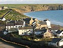
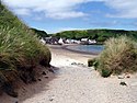
Gateholm or Gateholm Island is a small tidal island off the south west coast of Pembrokeshire, in the community of Marloes and St Brides, in the south west side of Wales, in the west of the UK, and about 8 miles (13 km) west of the port of Milford Haven. It is known for its Romano-British remains. Gateholm is owned by the National Trust as part of their Marloes Sands and Mere estate.

Drum Castle is a castle near Drumoak in Aberdeenshire, Scotland. For centuries it was the seat of the chief of Clan Irvine. The place-name Drum is derived from Gaelic druim, 'ridge'. The site is located approximately 6+1⁄2 miles northeast of Banchory and 3 miles west of Peterculter. The property is now owned by the National Trust for Scotland and is open to the public.

Studley Royal Park is an estate in North Yorkshire, England. The site has an area of 800 acres (323 ha) and includes an 18th-century landscaped garden; the ruins of Fountains Abbey; Fountains Hall, a Jacobean mansion; and the Victorian St Mary's church, designed by William Burges. Studley Royal House, around which the park and gardens were designed, burned down in 1946. The park, as Studley Royal Park including the ruins of Fountains Abbey, has been designated a World Heritage Site. It has also been designated a grade I listed park and garden by Historic England, and various structures within it are individually listed.

Plas Newydd is a country house set in gardens, parkland and surrounding woodland on the north bank of the Menai Strait, in Llanddaniel Fab, near Llanfairpwllgwyngyll, Anglesey, Wales. The current building has its origins in 1470, and evolved over the centuries to become one of Anglesey's principal residences. Owned successively by Griffiths, Baylys and Pagets, it became the country seat of the Marquesses of Anglesey, and the core of a large agricultural estate. The house and grounds, with views over the strait and Snowdonia, are open to the public, having been owned by the National Trust since 1976.

Henry Cyril Paget, 5th Marquess of Anglesey, styled Lord Paget until 1880 and Earl of Uxbridge between 1880 and 1898, and nicknamed "Toppy", was a British peer who was notable during his short life for squandering his inheritance on a lavish social life and accumulating massive debts. Regarded as the "black sheep" of the family, he was dubbed "the dancing marquess" for his Butterfly Dancing, taken from Loie Fuller, where a voluminous robe of transparent white silk would be waved like wings.

Erddig is a country house and estate in the community of Marchwiel, approximately 2 miles (3.2 km) south of Wrexham, Wales. It is centred on a country house which dates principally from between 1684 and 1687, when the central block was built by Joshua Edisbury, and the 1720s, when the flanking wings were added by its second owner, John Meller. Erddig was inherited by Simon Yorke in 1733, and remained in the Yorke family until it was given to the National Trust by Philip Scott Yorke in 1973.

Ridley Creek State Park is a 2,606-acre (1,055 ha) Pennsylvania state park in Edgmont, Middletown, and Upper Providence Townships, Delaware County, Pennsylvania in the United States. The park, about 5 miles (8 km) north of the county seat of Media, offers many recreational activities, such as hiking, biking, fishing, and picnicking. Ridley Creek passes through the park. Highlights include a 5-mile (8 km) paved multi-use trail, a formal garden designed by the Olmsted Brothers, and Colonial Pennsylvania Plantation, which recreates daily life on a pre-Revolutionary farm. The park is adjacent to the John J. Tyler Arboretum. Ridley Creek State Park is just over 16 miles (26 km) from downtown, Philadelphia between Pennsylvania Route 352 and Pennsylvania Route 252 on Gradyville Road.
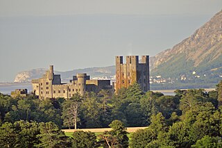
Penrhyn Castle is a country house in Llandygai, Bangor, Gwynedd, North Wales, constructed in the style of a Norman castle. The Penrhyn estate was founded by Ednyfed Fychan. In the 15th century his descendant Gwilym ap Griffith built a fortified manor house on the site.

Gwrych Castle is a Grade I listed country house near Abergele in Conwy County Borough, Wales. On an ancient site, the current building was created by Lloyd Hesketh Bamford-Hesketh and his descendants over much of the 19th and early 20th centuries. The castle and its 236-acre estate are now owned by a charity, the Gwrych Castle Preservation Trust.

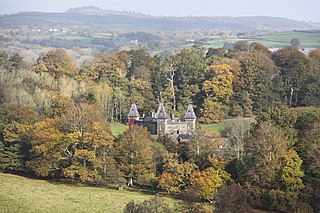
Newton House is a Grade II* listed country house situated just to the west of the market town of Llandeilo in Carmarthenshire, Wales. It is partially owned and maintained by the National Trust and lies within Dinefwr Park and the grounds of Dinefwr Castle. The park and gardens are listed on the Cadw/ICOMOS Register of Parks and Gardens of Special Historic Interest in Wales. The original house was built during the Medieval period on a site which has been occupied for at least two millennia. The current house was built by Edward Rice in the Jacobean style in 1660, though extensive changes were made in the 1850s in the Venetian Gothic style. The house played a role in the Rebecca Riots of 1843, when the occupant of the house at the time, Colonel George Rice-Trevor, 4th Baron Dynevor, received a death threat with an empty grave dug in the ground. After 1956 the property fell into turbulent times when two owners died within the space of a few years. It was sold in 1974, and later fell into disrepair; it was occupied by squatters and thieves who removed beams and furniture.
Dinefwr Park National Nature Reserve is an 800 acres (320 ha) estate about a mile from the centre of Llandeilo in Carmarthenshire owned by the National Trust, with a mansion in the centre. The highest point is occupied by the ruined Dinefwr Castle, ancient castle of the Deheubarth kingdom. It is a grade I Historic Park and a Site of Special Scientific Interest.

Sayes Court was a manor house and garden in Deptford, in the London Borough of Lewisham on the Thames Path and in the former parish of St Nicholas. Sayes Court once attracted throngs to visit its celebrated garden created by the seventeenth century diarist John Evelyn. Now completely buried beneath Convoys Wharf and Sayes Court Park, the area shows little sign of its former glory, despite having been a key factor in the creation of the National Trust.
The Bank Hall Estate is the demesne of the Jacobean mansion house of Bank Hall, including much of land around the village of Bretherton, which is owned by the Lilford Trust.

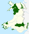
Carmarthenshire is a county in the south-west of Wales. It covers an area of 2,370 km2 (920 sq mi). In 2021 the population was approximately 188,200.
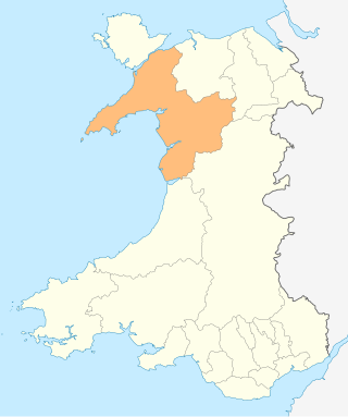
Gwynedd is a county in the north-west of Wales. It covers an area of 2,535 km2 (979 sq mi) and in 2021 the population was approximately 117,100.